All Activity
- Past hour
-
EPS also bumped up quite a bit from what I saw. Widespread 6-8" across SE PA at 10:1. Ratios get you 8-12". I think most would sign up for that
-

January 2026 regional war/obs/disco thread
40/70 Benchmark replied to Baroclinic Zone's topic in New England
Yea, need more phasing....as is, it's a moderate impact...maybe more if you considier the cold. -

2025-2026 Fall/Winter Mountain Thread
Maggie Valley Steve replied to Buckethead's topic in Southeastern States
Winter RECON Missions upcoming over the Pacific ENE of Hawaii sampling the Upper Low tomorrow. Additionally missions for the atmospheric River streaming in across the Baja and Texas are planned as well. -
I am waiting for someone over there to say "sun angle"

-
That was February 21, 2015. We had 1-2" of ice in Crossville. Most areas around us actually got mostly snow I think.
-
Oh yeah, there are many laughs to be had! I usually don't get too uptight about banter but traffic is gonna be so high. It's all good tho bc...zoomed out...this is what we live for!
-

1/23/26-1/25/26 Winter Storm Thread
Save the itchy algae! replied to AMZ8990's topic in Tennessee Valley
No doubt the plateau would be problematic. I’ll look into the ‘14/15 time frame I just don’t recall anything significant offhand. I’m also in Farragut which is the warmest/driest spot in the Central Valley so it could’ve just skirted us. -

Richmond Metro/Hampton Roads Area Discussion
RVASnowLover replied to RIC Airport's topic in Mid Atlantic
Going to be a long week of tracking. A lot can change between now and Saturday. I would be cautious too. We don't get snow events like this much anymore. -
Yeah the Valley warm nose in the last 15 years rescues Chattanooga (above freezing) but might ice Knox. This one the cold is too deep. If the mid levels stay warm, Chatty's luck has ended. Then the Upper Plateau has that same risk. Instead of elevation helping with snow, it only adds to the cold vs the Lower Valley. Then both are warm aloft. I would like to see one other model besides the GFS get less ice. For now, weekend concerns continue to mount.
-
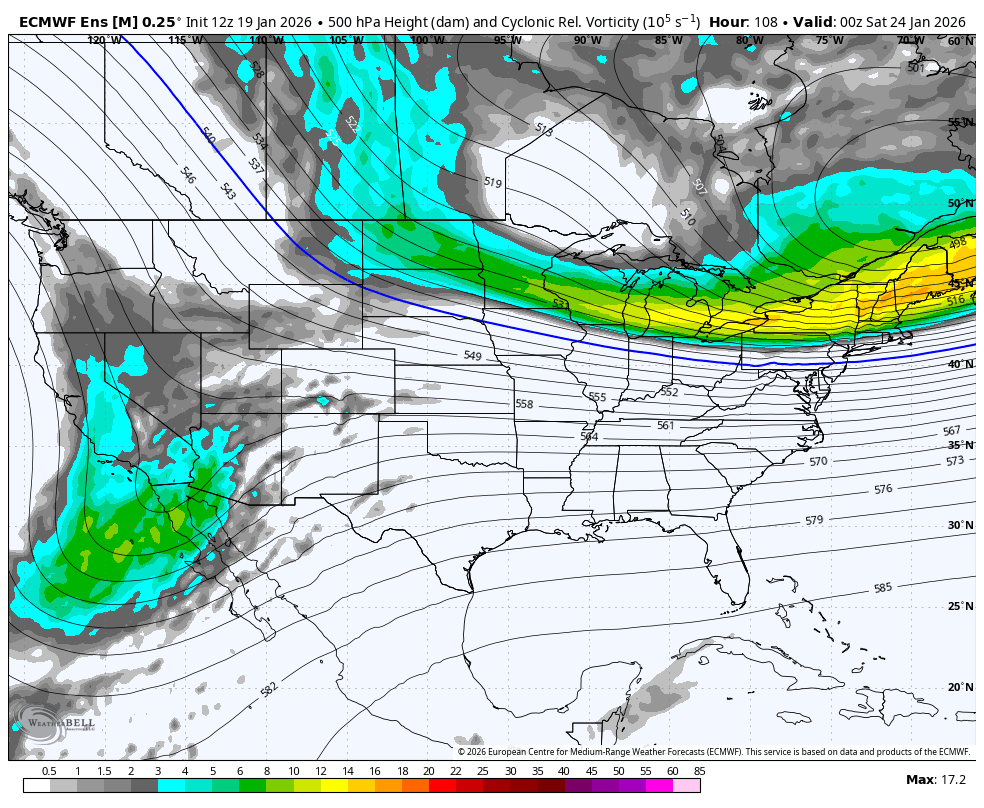
EPS trend with the energy pieces. Baja tend is good but northern energy trend is bad. All together bad for us in terms of wanting more snow and less ice. Can we trend back to a more progressive look with the northern energy? Progressive has been the theme of late but this is an entirely different pattern.

-

Possible Record Breaking Cold + Snow 1/25 - 1/26
SnowGoose69 replied to TriPol's topic in New York City Metro
Its pretty safe to say this event up this way will not be as insanely long duration in all likelihood as it may be down in the SE because they may see a crazy long overrunning period. I felt the 12Z Op Euro was gonna go full blown UKMET when I saw it through like 96 hours but it ultimately deviated after that. -
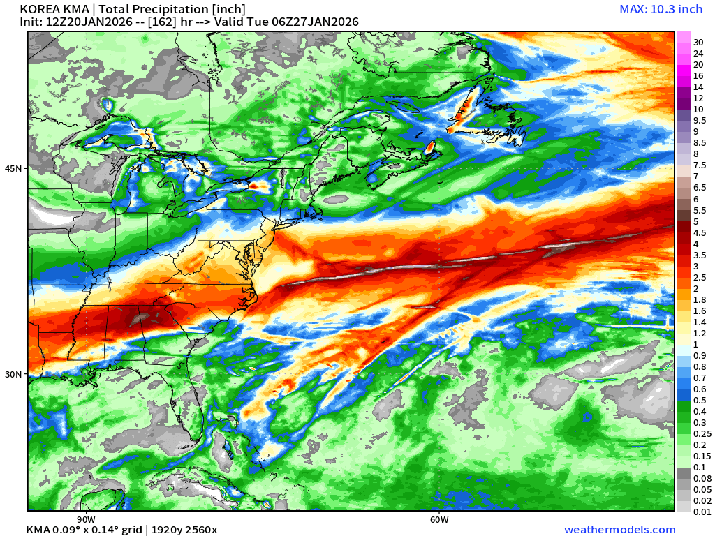
12z Korean with WELL OVER 1" of QPF regionwide

-
I can't help but think we are going to get the shaft again in Greene Co TN. Warm nose will creep in and cut totals down more than half. It drives me crazy how much things have changed in the last ten years or so with these storms. Our region was almost a lock on major snow events prior to the 2010s.
-
I,m just hoping we can get 1" liquid out of this thing. Kind of feels like weak sauce if we don't. 2010 and 2016 were close to 2-2.5" liquid equivalent if I remember correctly.
-

January 2026 regional war/obs/disco thread
RUNNAWAYICEBERG replied to Baroclinic Zone's topic in New England
Thanks friend. Lets get sleet to shatter their cruiser lights. -

January 25/26 Jimbo Back Surgery Storm
Brick Tamland replied to Jimbo!'s topic in Southeastern States
Not really different than the 10:1 ratio map. -
I am nostalgic for the old days when I’d check the newspaper or the local evening news once a day, and here I am on Tuesday checking the latest by hour and minute, multiple sources, for something thats not supposed to happen until Saturday. It’s excruciating, but, we have no choice these days. I guess good problem to have!
-
A little deeper on the mean and more hugging the coast, as well. Looks good all around
-
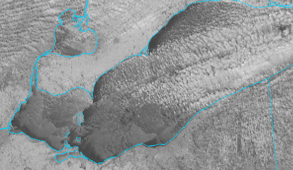
Lots of ice on the lake... most of it is probably mobile but its not going anywhere anytime soon. Seems like these arctic outbreaks always come with WSW wind lake effect events. Would have been nice to squeeze in one more event prior to the ice cover.
-

Possible Record Breaking Cold + Snow 1/25 - 1/26
weatherpruf replied to TriPol's topic in New York City Metro
that's really a long time to be snowing...... -

Central PA Winter 25/26 Discussion and Obs
GrandmasterB replied to MAG5035's topic in Upstate New York/Pennsylvania
Adding to what MAG and AccuChris stated on ratios here’s Millville from MA forum, “If you are north of the M/D, your average ratios will likely be >13:1” -

January 2026 regional war/obs/disco thread
JKEisMan replied to Baroclinic Zone's topic in New England
Yeah, crossing fingers but I think SNE is in a good spot for this one. We have a ways to go though, gonna be a fun one to track regardless. -
I'm trying to keep the faith. I want to think the GFS could score a coup. Until the energy gets onshore, I'm afraid I have to go with the Euro and all that frickin' ice.
-

January 2026 regional war/obs/disco thread
Damage In Tolland replied to Baroclinic Zone's topic in New England
I’d take a few inches of ZR at 12 degrees -
The last major ice storm in our region i recall was in the 2010's but was primarily the upper Cumberland Plateau. Maybe 2014, I don't remember exactly but my local utility Volunteer Electric had folks in Cumberland and Fentress still without power 2 weeks after event. In the valley at least my neck of the woods the last sizable ice storm was either 14 or 15 but it wasn't catastrophic maybe .2 inches. Caused some outages from pine trees falling on lines but nothing widespread. Sent from my Pixel 10 Pro XL using Tapatalk