All Activity
- Past hour
-
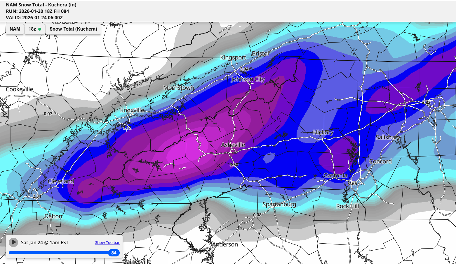
Could be thunder snow. 13.8” wow. JAX does this graph factor in ratio or standard 10:1?
-
2025-2026 New England Snow Recordkeeping Thread
subdude replied to bristolri_wx's topic in New England
I need to jump in on this. I miss updating the totals. I'm at 21.5" on the season. I may have missed a 1-2"er we've had a lot of them here. -

January 25-26 Winter Storm Potential
Violentweatherfan replied to Ralph Wiggum's topic in Philadelphia Region
Actually weak La Niña winters are great for big winter snows -

Central PA Winter 25/26 Discussion and Obs
paweather replied to MAG5035's topic in Upstate New York/Pennsylvania
Horst is great as well. -

E PA/NJ/DE Winter 2025-26 Obs/Discussion
Birds~69 replied to LVblizzard's topic in Philadelphia Region
C'mon you have to be more creative than that. That saying has been around since the 90's. Now this is brand spanking new! https://bubble-wrap.party/ -

January 25-26 Winter Storm Potential
Albedoman replied to Ralph Wiggum's topic in Philadelphia Region
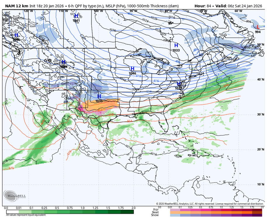
NAM at 48-56 hours HRRR at 36 to tighten it up. Thursday evening will tell us all what is going to happen, The watches should be out by then -

Central PA Winter 25/26 Discussion and Obs
Itstrainingtime replied to MAG5035's topic in Upstate New York/Pennsylvania
I'm having a hard time concentrating on enjoying my journey. I spent all of 4 hours offline doing some hiking but I can't stay away. For those who care, Horst (remember him) tweeted 2 hours ago - classic setup for a major winter storm. A crippling snow is possible...and so is a few inches. I'm sure he'll post again in the coming days. -
That's it. People are anxious.. need something to look at NOW and either validate their hopes or stress the fuck over.
-
It is anxiety talking for sure because this is make or break for the winter after years of paltry events.
-
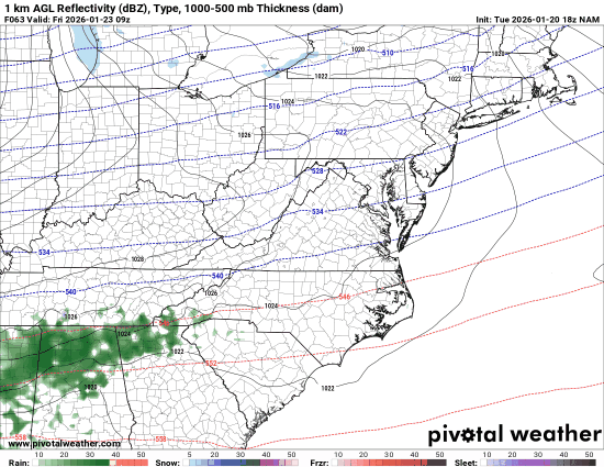
18Z NAM trying to throw us a teaser before the big event. Sign me up!
-
This was the surface depiction for the January 2022 sleet bomb. This stayed all sleet and snow in the triad (I think a little light ZR to end, but nothing significant). Just goes to show what a strong surface high will do for you. It seems very unlikely that Raleigh and points N & W will have a changeover to ZR for any significant amount of time. The question is will it be a 4-6" sleet bomb or a historic snowstorm
-
Revive the dgex!
-
Most models have that piece of energy, but it's strung out and probably too warm for anything except rain or mix
-
If you ask I’m sure he caused to happen with his birds
-
I mean, I’m happy to travel and want to be part of this meeting, but I’m going to miss potentially the biggest snow in 6-10 years over my dead body
-
National Weather Service Nashville TN 1137 AM CST Tue Jan 20 2026 ...New AVIATION... .KEY MESSAGES... Updated at 1134 AM CST Tue Jan 20 2026 - High confidence in winter weather with travel impacts this weekend. Stay tuned for the latest. - Cold temperatures are expected to remain through early next week which will prolong impacts. - Scattered showers expected tomorrow/tomorrow night with precipitation remaining as rain. && .SHORT TERM... (Rest of today through Wednesday Night) Issued at 1053 AM CST Tue Jan 20 2026 After a frigid start to the day, temperatures are climbing through the 20s this morning. High pressure is centered over the area but it will slowly move east this afternoon which will allow weak southerly flow to start. With that, temperatures will not be as cold tonight, but still expect lows in the 20s. A weak trough and associated surface low will approach on Wednesday dragging a weak surface front. Ahead of the front, the southerly winds will increase along with moisture. Models are showing medium to high chances of scattered showers starting Wednesday morning. The shower chances will linger into Wednesday night along the plateau. It looks like the precipitation will remain all liquid with this system. && .LONG TERM... (Thursday through next Tuesday) Issued at 1053 AM CST Tue Jan 20 2026 Behind Wednesday`s system, temperatures will remain around normal for this time of year. Surface high pressure will slide eastward from the central plains and quickly move across the Ohio River Valley. Behind that, a reinforcing cold front will move into the area on Friday. This will set the stage for this weekend`s system. An upper level trough will be situated off the southern coast of California on Friday. Ahead of the trough, southwesterly flow will send anomalously high moisture through the southern plains and into the southeast. This will override the cold air that settles into our area on Friday. In addition, some of that energy is expected to eject out of the Baja region eastward on Saturday. There are questions regarding how much energy is ejected and if it phases with upper level energy coming out of Canada. Regardless, precipitation is likely to start as snow either Friday night or Saturday morning. The question is what happens after that. The model solutions that eject more energy out of the Baja develop a stronger inverted surface trough over the southeast and possibly reaching into our area. This would do two things. First, it would enhance QPF amounts and second, it would draw warm air northward which would bring ice and sleet into the picture. Right now, sleet and freezing rain chances are highest closer to the Tennessee/Alabama border but there is still a lot of variation in model solutions. So what are the key messages regarding this weekend? Bottom line... we have high confidence in winter weather with impacts this weekend. Go ahead and make preparations and don`t plan on traveling if you don`t need to. It is not a simple setup that gives us high confidence in snow or ice amounts. Yes, there are individual models that say a large portion of the area will receive a foot of snow. BUT, on the flip side, there are models that bring the warm air well into Middle Tennessee which would produce more freezing rain or sleet which would crush the hearts of snow lovers, but still produce significant impacts. Any precipitation that falls will likely stick around as the cold air will be entrenched into at least early next week. We`ll continue to monitor the forecast trends in the models, so stay tuned as there is still some time to figure this out. && .AVIATION... (18Z TAFS) Issued at 1134 AM CST Tue Jan 20 2026 VFR conditions are expected to continue for the taf period. The low level jet will increase after 06z introducing a window for low level wind shear at BNA/CKV/MQY. Surface winds will increase mid to late Wednesday morning allowing for the LLWS to subside. Light scattered showers could impact the terminals starting from west to east Wednesday morning. && .PRELIMINARY POINT TEMPS/POPS... Nashville 38 27 49 34 / 0 0 70 40 Clarksville 38 26 45 30 / 0 10 70 10 Crossville 33 21 47 34 / 0 0 50 60 Columbia 40 25 49 35 / 0 0 70 40 Cookeville 33 23 49 35 / 0 0 60 60 Jamestown 31 21 48 33 / 0 0 50 50 Lawrenceburg 39 25 50 37 / 0 0 70 50 Murfreesboro 38 23 50 36 / 0 0 60 50 Waverly 38 27 44 31 / 0 0 70 20 &&
-
Omg yes lol
-

2025-2026 Fall/Winter Mountain Thread
BlueRidgeFolklore replied to Buckethead's topic in Southeastern States
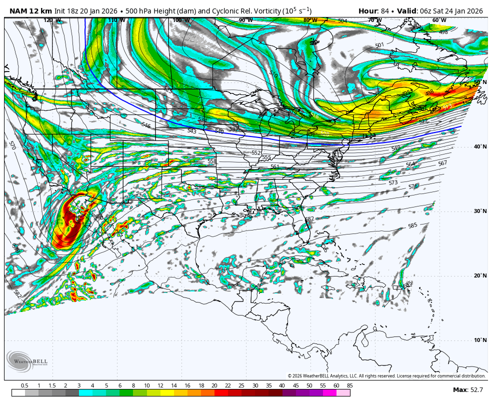
I know it's the long range NAM but did anyone see the nice little thump the 18z showed for Friday?
-
No idea, and I don't care to know what they were talking about, or why.
-
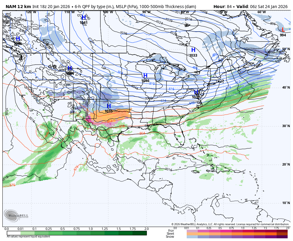
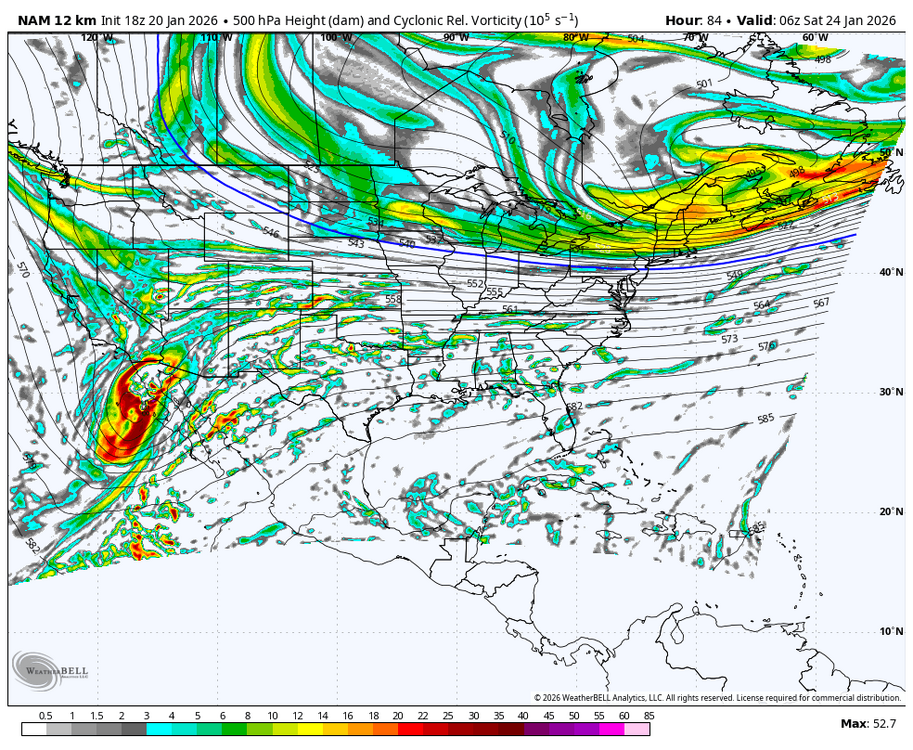
Piss Cape off and extrapolate at will: WB 18Z 12K NAM at fantasy range.
-
I do not speak the name of that system anymore. Greeneville got nothing but slush and sleet when the rest of the county got 5-7''
-

Possible Record Breaking Cold + Snow Sunday 1/25 - Tuesday 1/27
BoulderWX replied to TriPol's topic in New York City Metro
I think you mean 18z an 6z (18z up next) and there’s much debate on how accurate that is. But your point about overreactions is valid lol -
Central PA Winter 25/26 Discussion and Obs
paweather replied to MAG5035's topic in Upstate New York/Pennsylvania
Rightfully so, still days away this is going to be a long week. -

January 2026 regional war/obs/disco thread
WinterWolf replied to Baroclinic Zone's topic in New England
Jan 16, but we knew what you meant. That was actually pretty good up to my hood..but not to far north of me it cut off big time. -
18z NAM says, I am going start a pep rally Friday morning for the big game on Saturday. Like what the heck is the NAM thinking??