All Activity
- Past hour
-
Yes, agree. The watch that just came out from them goes into E PA which was a bit surprising to me considering the new watch box would go overtop that... I guess your idea would work
-

E PA/NJ/DE Summer 2026 Obs/Discussion
The Iceman replied to PhiEaglesfan712's topic in Philadelphia Region
Yes, that was also a very messy convective day in the morning but it didn’t matter because the deep layer shear was in place. Very similar set up. -

Saturday, July 18, 2026 Thunderstorm/Severe Weather Potential
Hoth replied to weatherwiz's topic in New England
Fine by me. Took a week to finish cutting up the trees that fell during the 7/4 storm. -

2026 Mid-Atlantic Severe Storm General Discussion
high risk replied to Kmlwx's topic in Mid Atlantic
It does, although as their discussion mentions, the wind profiles are much more supportive of tornadoes to our northeast. Personally, I would put a tornado box over NJ, DE, southeast PA, and a severe box over MD and VA, but I can see where those shapes don't really fit around the initial box over PA. -

Central PA Summer 2026 Discussion/Obs Thread
mahantango#1 replied to Voyager's topic in Upstate New York/Pennsylvania
SEVERE THUNDERSTORM WATCH 492 IS IN EFFECT UNTIL 900 PM EDT FOR THE FOLLOWING LOCATIONS PAC001-003-005-007-009-013-019-021-023-027-031-033-035-037-039- 041-043-047-049-051-053-055-057-059-061-063-065-067-071-073-075- 081-083-085-087-093-097-099-105-107-109-111-113-117-119-121-123- 125-129-133-190100- /O.NEW.KWNS.SV.A.0492.260718T1700Z-260719T0100Z/ PA . PENNSYLVANIA COUNTIES INCLUDED ARE ADAMS ALLEGHENY ARMSTRONG BEAVER BEDFORD BLAIR BUTLER CAMBRIA CAMERON CENTRE CLARION CLEARFIELD CLINTON COLUMBIA CRAWFORD CUMBERLAND DAUPHIN ELK ERIE FAYETTE FOREST FRANKLIN FULTON GREENE HUNTINGDON INDIANA JEFFERSON JUNIATA LANCASTER LAWRENCE LEBANON LYCOMING MCKEAN MERCER MIFFLIN MONTOUR NORTHUMBERLAND PERRY POTTER SCHUYLKILL SNYDER SOMERSET SULLIVAN TIOGA UNION VENANGO WARREN WASHINGTON WESTMORELAND YORK $$ SEVERE THUNDERSTORM WATCH OUTLINE UPDATE FOR WS 492 NWS STORM PREDICTION CENTER NORMAN OK 100 PM EDT SAT JUL 18 2026 SEVERE THUNDERSTORM WATCH 492 IS IN EFFECT UNTIL 900 PM EDT FOR THE FOLLOWING LOCATIONS WVC009-029-049-051-061-069-077-103-190100- /O.NEW.KWNS.SV.A.0492.260718T1700Z-260719T0100Z/ WV . WEST VIRGINIA COUNTIES INCLUDED ARE BROOKE HANCOCK MARION MARSHALL MONONGALIA OHIO PRESTON WETZEL $$ -

2026-2027 Super El Nino
snowman19 replied to Stormchaserchuck1's topic in Weather Forecasting and Discussion
-
I especially like the guy sweeping the water away…
-
E PA/NJ/DE Summer 2026 Obs/Discussion
The Iceman replied to PhiEaglesfan712's topic in Philadelphia Region
Sounds like a tornado watch is incoming… pretty strong wordage in the Mesoscale discussion: DISCUSSION...Strong boundary-layer heating of a very moist air mass is ongoing across the discussion area as of 1645z, contributing to moderate/pockets of strong surface-based instability. Thunderstorms will continue to increase in coverage across the higher terrain, and along a north-south confluence zone across southern PA south into northern VA, during the next few hours. As coverage continues to increase and low-level lapse rates steepen, the potential for damaging gusts will increase across the discussion area this afternoon and early evening. Additionally, low-level shear will remain locally enhanced in the vicinity of a warm front across southeast PA/southern NJ. Deep-layer shear will be supportive of supercell structures, and the risk for tornadoes, potentially strong, will be maximized in this area. -
The lightning in these overnight cells gets intense, and if you happen to find yourself under one, look out. I had a tree struck around 2AM here. Virtually no wind. Just periods of frequent CGs.
-
Bouts of very heavy rain in CNJ
-
Intense rain and lightning
-
I've always noticed that warm front storms have the most lightning.
-
Visiting Stone Mountain State Park NW of Winston-Salem. Not to hot but quite humid. Late morning thunder booming as we hit the summit was neat.
-
(002).thumb.png.6e3d9d46bca5fe41aab7a74871dd8af8.png)
E PA/NJ/DE Summer 2026 Obs/Discussion
ChescoWx replied to PhiEaglesfan712's topic in Philadelphia Region
Below is the first time I have used AI (Claude) to help analyze the Chester County Data set with data from 1893 to Present. Below is the average number of 90+ days by station and month. Including the years of record and the overall annual average. It did this correctly! see below.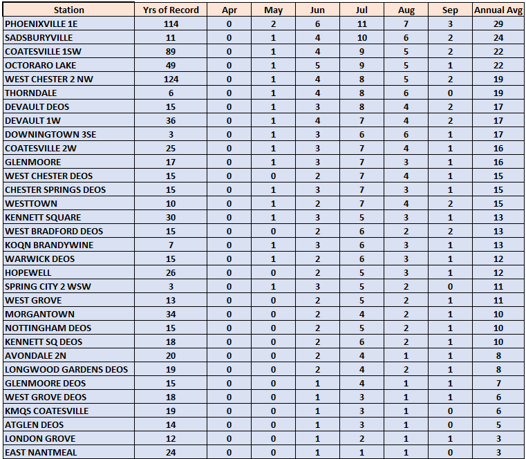
-
Subway and street flooding videos already coming in from the first round. https://www.instagram.com/p/Da8Q8RokS4r/?img_index=1&igsh=d250NzN4YjdiMzhu
-
Up to 1.00” already
-
Absolutely pouring with intense lightning in Union County NJ
-
Gotta love warm front storms , sometimes they produce the best.
-
1.3” on the day so far.
-
https://www.spc.noaa.gov/products/md/md1648.html Mesoscale Discussion 1648 NWS Storm Prediction Center Norman OK 1150 AM CDT Sat Jul 18 2026 Areas affected...portions of southern Pennsylvania...eastern West Virginia...northern Virginia...much of Maryland...Delaware...southern New Jersey Concerning...Severe potential...Watch likely Valid 181650Z - 181815Z Probability of Watch Issuance...80 percent SUMMARY...Thunderstorms are expected to increase in coverage and intensity through early-mid afternoon. Damaging winds will be the primary concern as storms evolve into eastward-moving clusters and line segments. A watch is likely prior to 18z. DISCUSSION...Strong boundary-layer heating of a very moist air mass is ongoing across the discussion area as of 1645z, contributing to moderate/pockets of strong surface-based instability. Thunderstorms will continue to increase in coverage across the higher terrain, and along a north-south confluence zone across southern PA south into northern VA, during the next few hours. As coverage continues to increase and low-level lapse rates steepen, the potential for damaging gusts will increase across the discussion area this afternoon and early evening. Additionally, low-level shear will remain locally enhanced in the vicinity of a warm front across southeast PA/southern NJ. Deep-layer shear will be supportive of supercell structures, and the risk for tornadoes, potentially strong, will be maximized in this area. Convective trends will continue to be monitored, and a watch is likely prior to 18z. ..Bunting/Thompson.. 07/18/2026 ...Please see www.spc.noaa.gov for graphic product... ATTN...WFO...PHI...AKQ...CTP...LWX...PBZ... LAT...LON 39077931 40007859 40547698 40477526 40267451 39987411 39137439 38627538 38437699 38487839 38647934 39077931 MOST PROBABLE PEAK TORNADO INTENSITY...100-125 MPH MOST PROBABLE PEAK WIND GUST...55-70 MPH MOST PROBABLE PEAK HAIL SIZE...UP TO 1.25 IN
- 1,069 replies
-
- 1
-

-
- severe
- thunderstorms
- (and 7 more)
-

2026 Mid-Atlantic Severe Storm General Discussion
DDweatherman replied to Kmlwx's topic in Mid Atlantic
Growing concerned looking at the parameters and sun is beating down nicely at the moment. Lots of little boundaries as well that could enhance some supercells.. assuming development continues upstream. -
Coming down in buckets. This is wonderful.
-

2026-2027 Super El Nino
LakePaste25 replied to Stormchaserchuck1's topic in Weather Forecasting and Discussion
Yeah which makes sense. It lags both from warmth going bottom-up in the tropics via instability/upper level divergence and from planetary scale baroclinicity aloft, which seasonally strengthens in late NH summer and early fall as the Arctic cold pool begins to develop. -

Saturday, July 18, 2026 Thunderstorm/Severe Weather Potential
Modfan2 replied to weatherwiz's topic in New England
7/10 split with the first round in CT? -
Sounds like leaning towards Tornado Watch
- 1,069 replies
-
- 1
-
-
- severe
- thunderstorms
- (and 7 more)