All Activity
- Past hour
-

E PA/NJ/DE Summer 2026 Obs/Discussion
nesussxwx1 replied to PhiEaglesfan712's topic in Philadelphia Region
Was busy this weekend so wasn't able to send updates but the storm on Saturday was one of the worst I've seen in a long time. Was stranded on 295-S near Deptford, had to pull over. Hope everyone is safe. Video_1.mov Best, -
 Uggh…This summer is almost as painful as most of last winter in regards to storms. Jesus…Even for a typical non severe summer it has been frustratingly quiet. Of course not the case W/S/N of us. Even saw some grow over the ocean east of us once. Ok. Rant over
 -
 Aroostook has seen a surprising number of tornados, considering it is far north and hilly. The densest area for wind damage (tornado and straight line) seems to be the Fish River chain of lakes, Eagle, Square, Long. In this century there have been damaging wind events - including tornados - from Oxbow to the town of Eagle Lake. Public Lands had loggers salvage 1,900 cords from 60 acres south of Eagle Lake in 2005 and 3,000 acres in 2013 from a 200+-acre blowdown north of the lake. The granddaddy event was older, 600 acres Eagle to Square Lakes flattened by straight line wind on 9/30/1986. The Bureau salvaged about 3,000 cords from 300 acres (not all were reached) and J.D. Irving salvaged at least as much on their half of the blowdown.
 -
 I guarantee the vast majority of people here have never bothered to read the entirety of their home insurance policy....they will be surprised when they read the part about paying a certain percentage of the damage ... How many home owners have flood insurance??
 -
I'm not sure how he knows, maybe just speculation, but Glenn Burns (Atlanta area Met) is predicting an unstable PV this winter. So he compared it to a likely colder El Nino pattern vs some of the stinkers with strong PV set ups.
-
 I think tomorrow is going to be very close with BDL tying their all time record low.
 -
 You didn't happen to teach Biology at Manchester Central HS in about 1990 or so did you? I had a teacher there that was super passionate about all of this and would occasionally use us students as a captive audience to vent to. Sounded just like this! I recall this one time when he was on a tear, face getting more and more red as he went on, none of us saying anything and then that apparently pissed him off too so he lays into us with "Are you fkn listening to me!!!?!?!?" We're all kind of like "Yeah, we really don't have a choice". There was this one skinhead kid in class though that piped up and said "Calm down dude! You're losing it!" Good times. People definitely get passionate about topics they hold dear. Fuck Central HS.
 -

Central PA Summer 2026 Discussion/Obs Thread
Itstrainingtime replied to Voyager's topic in Upstate New York/Pennsylvania
Also interesting that according to CTP's morning graphics that York and Lancaster counties are to have the LOWEST Heat Index values tomorrow in their forecast area. On Wednesday, York and Lancaster will be the highest. -

2026-2027 Super El Nino
snowman19 replied to Stormchaserchuck1's topic in Weather Forecasting and Discussion
We likely see a sizable jump come with next Monday’s update based on the ongoing warming in 1+2 and 3.4. I actually expected region 4 to come in around +0.4C as the SST charts were showing a cooling there. That is definitely one difference from previous recent Ninos where we saw region 4 way above average with consistent warming each week. Anyway, the models are already keying in on yet another WWB -
 NAM dries out quickly aloft Wed. Best shot is near S coast.
 -

Central PA Summer 2026 Discussion/Obs Thread
Mount Joy Snowman replied to Voyager's topic in Upstate New York/Pennsylvania
Low of 62 here as well. -
 Let’s see if we can gin one up this summer/ fall
 -
Had another round of very heavy rain early this morning that put down .95 inches. The Friday and Saturday portion of the flood watch didn't see much action imby with only around .8 inches of rain over both days, but the last 24 hours have delivered almost 4 inches.
-
May change later....
-
I know several families who moved back to New England after experiencing a hurricane while living in Florida.. People in New England are ill prepared for a direct hit from a strong hurricane. They talk tough but that toughness would vanish once they realize that an Oct snowstorm is a flurry when compared to a direct hit from a major hurricane
-
-
80 now
-
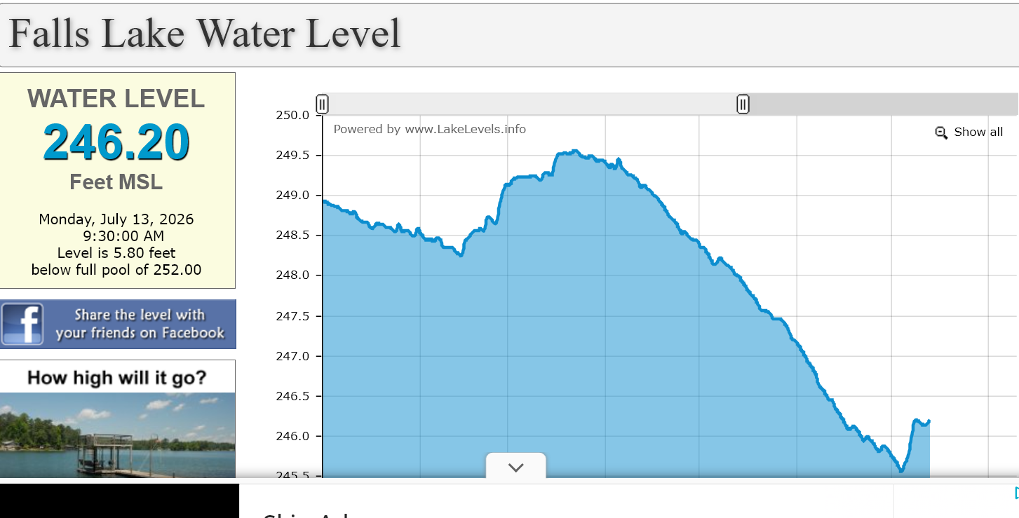
Falls Lake has risen by nearly a foot since all of this rain and will likely climb a bit more today.
-
It probably doesn't make it very far south at all. Looks like this will weaken quickly as it drops south across VT/NH. I do think there is still a shot for some storms in SNE on Wednesday south of the Pike, especially if the front can time a little slower. But convergence will be lacking and we may be drying out aloft quickly b/c the 850/700 front move through prior to the sfc front. I wouldn't totally sleep on it because if there are storms Wednesday there will be a increased risk for strong/severe
-
Kind of funny that an "all time" record doesn't even span 80 years.
-
something about 100+ in detroit and 89 imby feels weird but i'll take it
-
1.77 the last 12 hours and 2.06 the past 24 hours
-
 How far south does the line make it?
 -
Shocked that they're only going with a heat advisory and not a warning.
-
Yeah, sure! Whether it's 97 or 100 it's going to be crazy hot, might as well set a record. I'm pretty much down for any extreme type of weather. I have frozen watermelon and ice water for the chickens, and frozen baby carrots for my bunnies to munch on. Hopefully that will keep them from getting too hot this afternoon.