All Activity
- Past hour
-

January 2026 regional war/obs/disco thread
Damage In Tolland replied to Baroclinic Zone's topic in New England
Hand out beers to each student -

January 25-26 Winter Storm Potential
Army Mike replied to Ralph Wiggum's topic in Philadelphia Region
You all are all awesome been following this forum since 08 I think. Which short range model has the best handling of the H5 pattern. I only ask cause I like to just observed the baja feature in the short term. I guess since so much hinges on this coming together. I think that makes since . -
Okay we understand that you live in Magnolia Delaware... it is not about your backyard. Please keep the post on the threat itself and not IMBY.
-

January 25-26 Winter Storm Potential
No Snow Flo replied to Ralph Wiggum's topic in Philadelphia Region
No, we're not expecting those problems up here, at least not as of the 1300 conference call. SERC and ERCOT are going to have their hands full. -
I think we are in a good spot. I just feel like theres a lot of hostility around because of how many times we have been burned and we live and die model run to model run. .
-
Interesting that storm was also followed by a major arctic blast. Richmond recorded it's record low of -12 on the 29th.
-

January 2026 regional war/obs/disco thread
Sey-Mour Snow replied to Baroclinic Zone's topic in New England
Too early to tell, guidance hasn’t figured out which energy to phase yet, that will greatly affect start time. -
It’s a total troll account, nobody can be this dumb.
-
Flying down to DC Monday morning. I asked the Vermont cold to head down a few days ahead of me. You're welcome.
-
Area Forecast Discussion National Weather Service Morristown TN 122 PM EST Tue Jan 20 2026 ...New DISCUSSION, AVIATION... .KEY MESSAGES... Updated at 1258 PM EST Tue Jan 20 2026 - Confidence in a significant winter storm affecting the southern Appalachian region Saturday into Sunday is increasing. However, it must be stressed that details on where the axis of heaviest precipitation and resulting wintry precip totals remain unclear. This weekend`s system should be monitored closely over the next couple of days. - Cold air behind this weekend`s storm will keep temperatures at/below freezing for at least a day or two. This will prolong the effects of any winter weather, with power outages possible as well. && .DISCUSSION... Issued at 1258 PM EST Tue Jan 20 2026 Confidence continues to increase with regards to the potential for a high impact winter weather event affecting the southeast United States this weekend. As such, I`ll devote nearly the entirety of the forecast discussion to that event. Strong, deep troughing will remain over much of the central and eastern CONUS over the next several days, with quasi-zonal flow in place across the Gulf coast. One impulse embedded in the upper trough will drag a cold front into the region Wed night into Thu with some light rain expected across the forecast area. Afterwards a strong +1050mb surface high will drop out of Canada into the northern plains on Friday, reinforcing the front across the region and leading to some additional light precip on Friday possibly. However the main show is Saturday into Sunday. A very strong jet over the Ohio valley into the northeast, coupled with an upper low ejecting east from southern California, will result in widespread moderate to heavy precipitation across Tennessee and the surrounding areas. Timing wise, models agree fairly well on the bulk of the precipitation starting around daybreak Saturday and continuing through Sunday morning before tapering off Sun afternoon. Where there is still significant disagreement, revolves around precip types and amounts. Some guidance indicates a warm nose pushing north to the I-40 corridor while other guidance keeps it south of the Tennessee/Georgia border. The former would support significant icing in the south while central and northern areas get a significant snowfall event. The latter would support snow everywhere, with lighter totals further north and heavier amounts along and slightly south of the I-40 corridor. At this point in time, it`s difficult to tell which scenario is more likely to play out. What is pretty clear though is that a highly impactful winter weather event seems set to play out across the southern Appalachian region Sat and Sun. Regarding totals and precip types, it is worth noting that PWAT values for this event are well above climatological averages. That`s significant since it`s more likely to see unseasonably high PWATs in warm, heavy rain events versus cold winter weather events. Given the thermal profiles snow ratios aren`t going to be crazy high, so I would expect the snow to be a heavier/wetter type. This coupled with the potential of some icing somewhere means that power outages will be a distinct possibility. Lastly, whatever falls on Sat/Sun isn`t going anywhere in quick fashion. Temperatures on Sunday through Tuesday are going to be quite cold and I undercut NBM guidance a bit on Sun/Mon to account for temperatures being impacted by whatever snowpack is present.
-
Dang. I just looked. You're closer to NJ than the Chesapeake Bay.
-
Also sitting near Winston Salem. Stick around a few model runs and you may not feel like this will be fun. I think our chances of cold, quiet and dark are greater than white fluffy snow and sledding at this point. Mis-time this phase and we wave to our snow as it heads off into the abyss, or wherever all the snow goes that we seem to be missing.
-

Possible Record Breaking Cold + Snow 1/25 - 1/26
NEG NAO replied to TriPol's topic in New York City Metro
guess which model they are hugging ? -

Richmond Metro/Hampton Roads Area Discussion
Conway7305 replied to RIC Airport's topic in Mid Atlantic
this is the national blend of all models, pretty awesome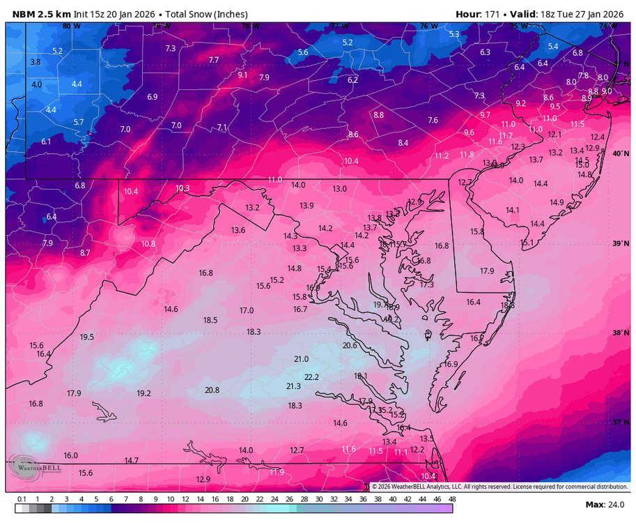
-

Central PA Winter 25/26 Discussion and Obs
paweather replied to MAG5035's topic in Upstate New York/Pennsylvania
Yep agreed and it does look like NYC is on target to get a moderate/heavy snowstorm -
I’ve thought our likelihood all along was probably a miller b ish look for us, which would be great. A classic foothills special with several inches of snow, sleet and a glaze but I’m growing concerned by the minute that we’re trending away from several inches of snow, to novelty inches of snow with apocalyptic ice.
-
Richmond Metro/Hampton Roads Area Discussion
Conway7305 replied to RIC Airport's topic in Mid Atlantic
no, I just copied and pasted it from the main thread -
i had to talk half of the neighborhood ladies brigade text group of the ledge this morning.
-

January 25-26 Winter Storm Potential
anthonyweather replied to Ralph Wiggum's topic in Philadelphia Region
EURO ENS are much better than 00z -
DLH Area Forecast Discussion National Weather Service Duluth MN 1248 PM CST Tue Jan 20 2026 .KEY MESSAGES... - Brutally cold temperatures are expected through the weekend, with multiple days below zero Thursday through Sunday. Low actual temperatures in the negative 30s to 40F, and minimum wind chills in the negative 30s to 50s. The coldest days will likely be Friday and Saturday. - A couple areas of light snow pass over the region this evening through the day Wednesday. Accumulations of an inch or less are expected. - Light lake effect snow and clouds may persist along the South Shore through the weekend. && .DISCUSSION... Issued at 1243 PM CST Tue Jan 20 2026 Relative to the last couple days and the coming days, today and tomorrow will be fairly "mild" (in a northern mid winter sense). High temperatures above zero are expected this afternoon and Wednesday - with some folks seeing afternoon temperatures in the teens tomorrow! This temperature moderation is occurring thanks to some WAA ahead of a couple passing upper level vort maxes spurring on some weak surface clippers. These will pass through this evening through Wednesday bringing a couple areas of light snow. The first passes through this evening, mostly from Brainerd to Hayward. The second should move across the area from northwest to southeast through the day Wednesday with a little wrap around snow lingering into Thursday morning. Total accumulations should be around an inch or less across the region. Behind the Wednesday clipper, a hefty cold air mass is expected to drop into the Northern Plains, Midwest, and Great Lakes region through the weekend with 850mb temperatures dropping into the -30s Celsius. This is expected to result in several days of some very cold surface temperatures beginning Wednesday evening through at least Sunday midday, when temperatures are unlikely to rise much above zero, if at all. The coldest days of this period are expected to be Friday and Saturday. Thursday and Friday, brisk northwest winds are expected which will lead to the coldest winds chills of this period Thursday night into Friday morning. Wind chill values of -40 to -50F are possible. The coldest actual air temperatures are expected Friday night into Saturday morning when widespread temperatures of -30 to -40F are forecast. There is a 5 to 10% chance that some of the local coldest spots could drop to -50F actual temperature on Saturday morning. With these cold temperatures and high confidence in them occurring, we`ve issued a plethora of cold weather headlines with this forecast update. For Wednesday evening into Thursday morning/midday, we`ve gone ahead and issued a Cold Weather Advisory for much of the area, with an Extreme Cold Warning along the far north. The Borderlands warning and the advisory along the Iron Range/North Shore continue through the day on Thursday as any diurnal warming is expected to be minimal. Thursday evening, the whole area falls into a Extreme Cold Watch through midday Saturday. Sunday and Monday mornings will likely feature more Cold Weather Advisories but shouldn`t be as brutally cold as Friday/Saturday. Looking ahead to next week it appears we`ll moderate slightly but still be below normal. There are little to no chances of snow after tomorrow`s clipper, outside of the South Shore possibly getting some on/off lake effect with the northwest winds and cold temperatures. Global models show a slight chance of snow returning mid next week as slightly warmer temperatures allow moisture back into the area.
-

2025-2026 Fall/Winter Mountain Thread
Maggie Valley Steve replied to Buckethead's topic in Southeastern States
I've got to say, that was probably the best AFD from GSP I seen since just before Helene. Obviously this is an all of Government event from the local, County, State and Federal. Every meteorological asset we have is being thrown at this upcoming event. I expect some big changes ahead the next coming days in regards to modeling with the RECON data being assimilated. -
I got my KU book signed by him years ago. Great dude.
-

Possible Record Breaking Cold + Snow 1/25 - 1/26
wishcast_hater replied to TriPol's topic in New York City Metro
Just heard 1010 WINS mentioning a storm system for this weekend but misses us to the south. SMH. I guess its possible and then mass suicide would be occuring on this board. -
And it begins..WSW up now TX, AR, LA