All Activity
- Past hour
-
Strong signal across all global ensembles for a cooler than average Memorial Day weekend.
-
Here now. Booming thunder and pouring rain. Needed a little excitement from this lame event lol.
-
@CAPE I think those storms in Southern Delaware are shifting Northwest towards you
-
Any MCS early Saturday would likely be elevated and therefore unlikely to have any SVR threat. It’s just so difficult to get severe here outside of the period of peak heating.
- 504 replies
-
- 1
-

-
- severe
- thunderstorms
- (and 2 more)
-
I wonder what ffg is like right now out this way. Lots standing water in the yard and creek remains high. I would think a quick .6+ would cause flash flooding. Storms to the south seem to be pushing in this general direction.
-
High and dry in the sunshine state for the next week, at least with the ridge overhead. We might get to hurricane season with no additional precip is Sofla. Sent from my Pixel 9 using Tapatalk
-
The map is effective as of Tue 8am but still should be a good improvement.
-
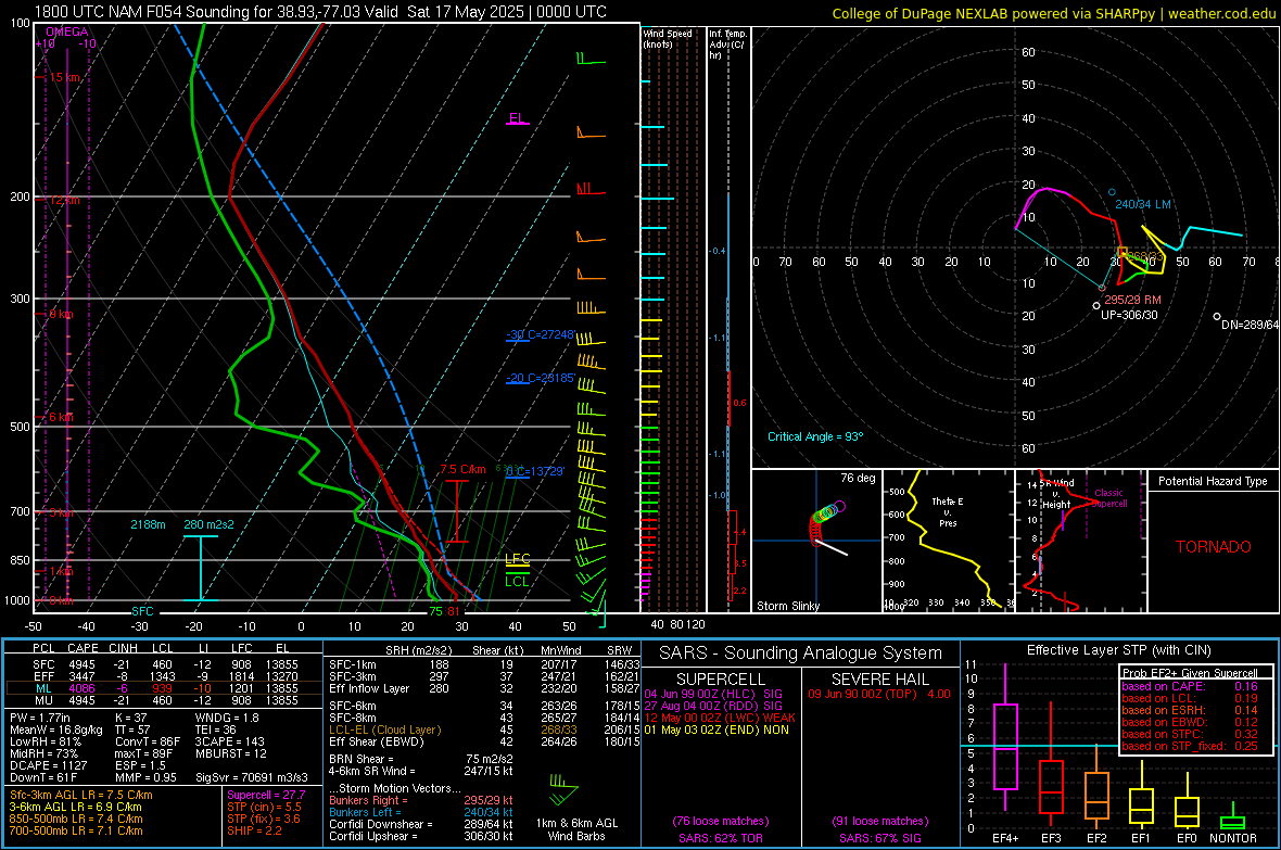
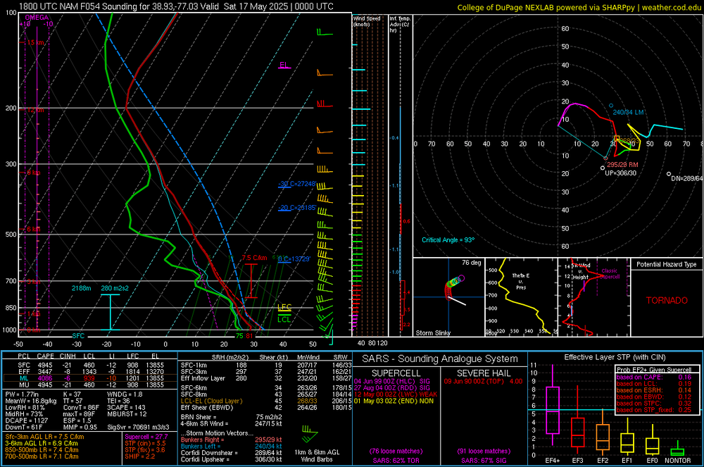
I know we've mentioned the trigger issue, but damn, that 18z NAM sounding for DC metro at 00z Saturday
-
Since we’re on the topic of that 1965 Palm Sunday Outbreak, I produced a half hour special report for my station on the 60 year anniversary of it last month. Enjoy!
-
I’m buying this event and am ready to wedge tomorrow
-
Alaska rivals Hawaii as the most beautiful states, so not too shabby there...
-
with all the rain we been getting lately i am very interested in tomorrow drought monitor report i expect a vast improvement area wide..
-
Lots of apples and oranges to unpack in that statement, but the discussion seems to be more around the weather generated on the interface between the east side of continents and adjacent oceans. It's about 2500 miles from Labrador to Miami. Its about 2700 miles from Valdivostok to Ho Chi Minh City (Saigon). I don't think the extremes that you are imagining are real (temperature extremes and snowstorms), except for possibly the number of TC's in the northern Pacific (any chance you were adding in TCs from the southern pacific?). The mountains of northern Japan in winter are a special case in a similar sense to the way that the Tug Hill is. There is nothing tiny about the coastline adjacent to either continent.
-
That was my thought as well. But this one would have a bit more of a northerly component compared to those storms. Coworker of mine told me her story of surviving the Palm Sunday f4 just a few months ago.
-
Feels like another very wet night for the Frederick area ahead.
-

-
.35 today and it's pouring now.
-
You may want to give the Canadians a say in that idea Liberty. Stay well, as always …..

-
Drunkchumpy !
-
Chumpy!
- Today
-
That supercell takes basically the same track as the Palm Sunday F4s, eerie.

-
Flash flood watch for parts of DC metro. Flood Watch National Weather Service Baltimore MD/Washington DC 400 PM EDT Wed May 14 2025 VAZ031-053-055-057-501-502-505-506-526-527-WVZ052-053-150400- /O.EXB.KLWX.FA.A.0005.000000T0000Z-250515T0400Z/ /00000.0.ER.000000T0000Z.000000T0000Z.000000T0000Z.OO/ Clarke-Fairfax-Stafford-King George-Northern Fauquier-Southern Fauquier-Western Loudoun-Eastern Loudoun-Northwest Prince William- Central and Southeast Prince William/Manassas/Manassas Park- Berkeley-Jefferson- 400 PM EDT Wed May 14 2025 ...FLOOD WATCH IN EFFECT UNTIL MIDNIGHT EDT TONIGHT... * WHAT...Flooding caused by excessive rainfall continues to be possible. * WHERE...Portions of Virginia, including the following areas, Central and Southeast Prince William/Manassas/Manassas Park, Clarke, Eastern Loudoun, Fairfax, King George, Northern Fauquier, Northwest Prince William, Southern Fauquier, Stafford and Western Loudoun and panhandle West Virginia, including the following areas, Berkeley and Jefferson. * WHEN...Until midnight EDT tonight. * IMPACTS...Excessive runoff may result in flooding of rivers, creeks, streams, and other low-lying and flood-prone locations. Area creeks and streams are running high and could flood with more heavy rain. * ADDITIONAL DETAILS... - Numerous showers and thunderstorms will move gradually northward through the area through this evening. While not as widespread as yesterday, isolated rainfall amounts of 1 to 3 inches are possible in a one to two hour period. Should these rainfall amounts occur over sensitive or urban areas, flash flooding is possible.
-
Looks like northeast flow at the surface and southerly flow aloft. Probably enough convergence and limited instability to get a few cells firing up where the sun broke out a bit.
-
Catoctin Creek is very energetic rn. Not even sure that area needs another gully washer. The creek is getting precariously high along parts of Hamburg Road leading into the Watershed.
-
Why do TV mets sound like a broken record with *not a washout not a washout* etc. Why do they care if we think it's a washout or not? My definition of washout: If it rains in the morning and is cloudy for the entire day, regardless of whether it rains the rest of the day or not, it's a washout! I don't want wet ground or cloudy skies. It never rains an entire day anyway, so calling it *not a washout* has no real meaning. For example, although it is not raining right now*, it's been a washout. So just say it's going to rain and don't use the W word at all!