All Activity
- Past hour
-

E PA/NJ/DE Summer 2026 Obs/Discussion
Birds~69 replied to PhiEaglesfan712's topic in Philadelphia Region
Was surprised, no doubt but makes sense. She's loaded, why not enjoy life before the dreaded If it wasn't announced yet her replacement will probably be a female although I would give Chris Sowers a call since he's back in the area... 73F/Damn DP 72F -
 1.87 at CEF so far for the event. Not sure how much more to follow.
 -

2026-2027 Super El Nino
George001 replied to Stormchaserchuck1's topic in Weather Forecasting and Discussion
Wow this was back in March, well done. Interestingly the spring predictability barrier went the other way in that guidance was underestimating the strength of the El Niño. Imo this was a very well predicted event, it tipped its hand early and guidance already was flagging a potential super Nino in late winter/early spring. The biggest events really do tip their hand early. -
Fire Island?
-
My oldest just moved from Cathedral Heights. Told her about this from you.
-
2.10" at my house on the stratus gauge, 2.13 on my ambient station. Shocked they were so close with the rain intensity at times. I see the cocorahs map got my total, nice.
-
That is funny. Because I have been saying I guess I need to leave my house for it to get rain. I joke about me being a rain/storm deterrent. Some of the craziest weather I have been in for a while out here. Anyone here heard anything about Lovettesville with a lot of tree damage? Have a friend who says they think it was a tornado not seeing anything that would suggest that.
-
Heat adv out for NE MN & N WI except near the Lake. Very pleasant wx yesterday in the 70's with the same today.
-

Central PA Summer 2026 Discussion/Obs Thread
Mount Joy Snowman replied to Voyager's topic in Upstate New York/Pennsylvania
Sorry a bit late on this, but crystal ball says July will end with a mean temp of 78.0 -- tied with 1993 for 25th place all-time. Book it. Pretty remarkable considering where we were sitting after the first five days of the month. -
 I'm probably close to that figure here
 -
 how is that even possible? lol.
 -
1.92” at my station at Cherry Grove so far today.
-
2.09" so far with occasional rain continuing. 10.39" for the month
-
EWR with 5 89 degree days made it close as well as the last 2 weeks heat capped. Next 90s post 8/4 period looking warm - hot at times.
-
up near Albany close to 5-6 inches of rain-the jackpot ended up being the hudson valley
-
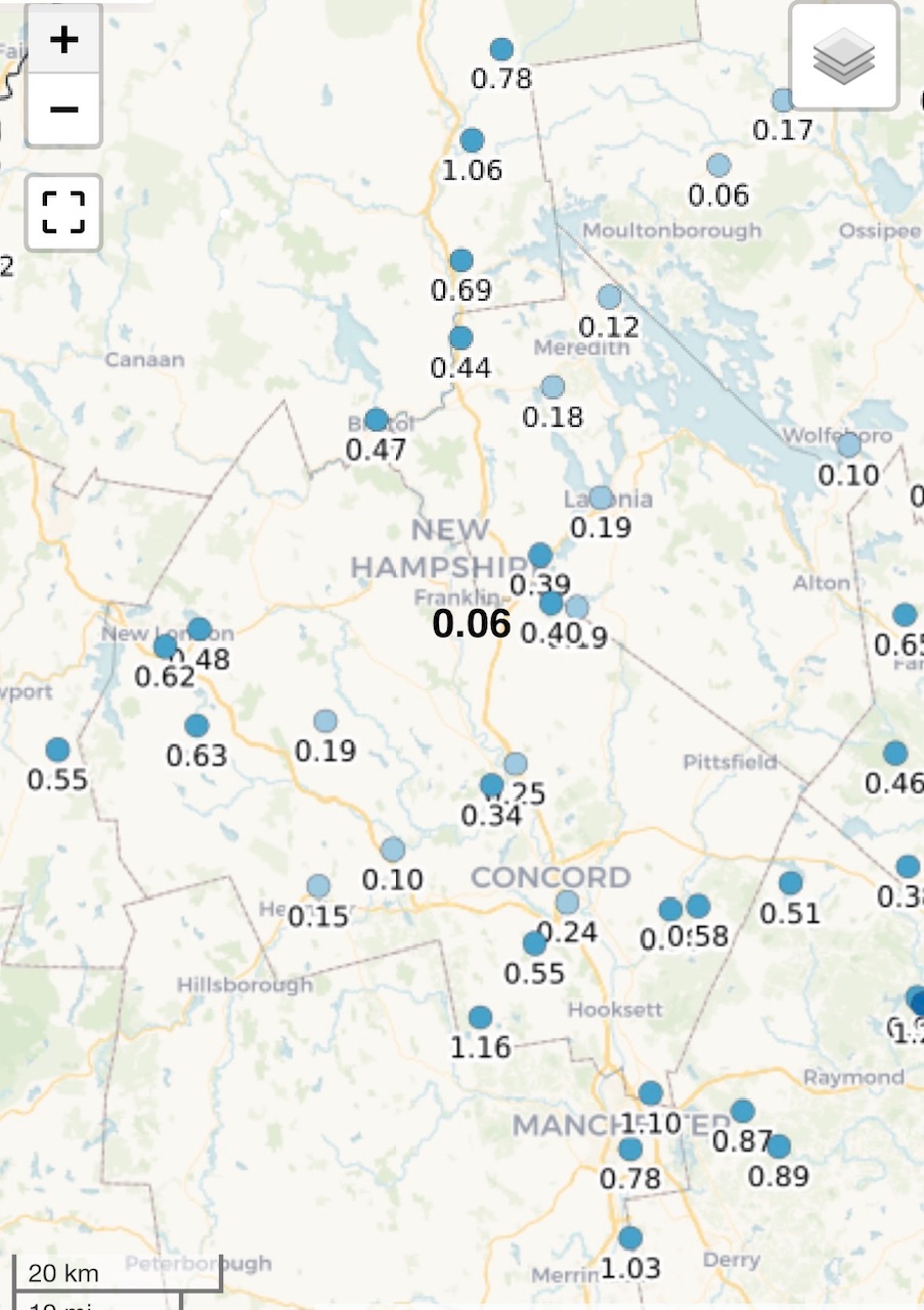
 You and moultonborough standing strong. Looks like we got over an inch here yesterday at the lake
 -
2.4-2.8 around my area. Local mesonets are 3.09 just S and 1.75 a few miles N.
-
The unstable air advected Eastward and the cap was broken. Don't see that too often around here, much more common in the plains
-
The fewer 90s in late July allowed the warm spots like Newark to pull back to the 10th highest number of 90s by July 28th following a very fast start by July 15th. Time Series Summary for NEWARK LIBERTY INTL AP, NJ Most 90° days by July 28th Click column heading to sort ascending, click again to sort descending. 1 2010-07-28 36 0 2 1993-07-28 31 0 3 2022-07-28 29 0 - 1987-07-28 29 0 4 1994-07-28 28 0 5 2025-07-28 27 0 - 2021-07-28 27 0 - 1991-07-28 27 0 6 2011-07-28 25 0 7 2024-07-28 24 0 - 2012-07-28 24 0 - 1999-07-28 24 0 - 1952-07-28 24 0 - 1949-07-28 24 0 8 2002-07-28 23 0 - 1988-07-28 23 0 - 1966-07-28 23 0 - 1955-07-28 23 0 9 2016-07-28 22 0 - 1944-07-28 22 0 10 2026-07-28 21 0 - 2013-07-28 21 0 - 2005-07-28 21 0 - 1943-07-28 21 Time Series Summary for NEWARK LIBERTY INTL AP, NJ Most 90° days by July 15th Click column heading to sort ascending, click again to sort descending. 1 2010-07-15 23 0 - 1993-07-15 23 0 2 2021-07-15 22 0 3 2024-07-15 21 0 - 1994-07-15 21 0 - 1987-07-15 21 0 4 2026-07-15 20 0 - 2022-07-15 20 0 - 1991-07-15 20 0 - 1966-07-15 20 0
-
2026-2027 Super El Nino
George001 replied to Stormchaserchuck1's topic in Weather Forecasting and Discussion
If the model projections are correct this event will be the strongest in history by a wide margin. In my opinion this could actually make analog forecasting tougher, because even other super Ninos like 2015-2016, 1997-1998, 1982-1983 have a decent chance ending up a full 1C weaker than this event. I’d still use those years because they are the closest matches we have to this one, but this truly is a once in a lifetime Godzilla El Niño. I’m thinking we see almost a more extreme version of those super Nino years (eg even stronger STJ than 97-98), but I’m really not sure what the implications are. What are your thoughts? As a northern skier I’m not too happy about this developing Godzilla nino, but at the same time I’ve always been drawn to extreme weather events, so it will be interesting to keep following this and see how things play out regardless. This one has a good what 5 months left of strengthening and is already above 2C on the dallies for ENSO 3.4, 3C for ENSO 3, and 4C for ENSO 1.2, and the subsurface is much more impressive than even 97-98. So really no ambiguity here, this Nino already is a beast and will continue to break records. -
 I melted quite a bit yesterday, but we were strategically missed multiple times.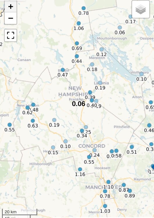
-

WPAC, Indian Ocean, and Southern Hemisphere Tropical Cyclones
GaWx replied to 1900hurricane's topic in Tropical Headquarters
“Typhoon Dolphin is expected to strengthen into a violent storm as it moves towards Japan's remote Minami-Torishima Island, the Japan Meteorological Agency said on Wednesday.” https://en.wikipedia.org/wiki/Minamitorishima -
I’ll take this back, I was wrong. That supercell that pushed from VA through here to the coast was legit
-
… almost 6” on the month with more to come today and trying to sell it as Stein. Even here, it’s rained like twice, but we’re over 5”. The numbers are the numbers
-
(002).thumb.png.6e3d9d46bca5fe41aab7a74871dd8af8.png)
Central PA Summer 2026 Discussion/Obs Thread
ChescoWx replied to Voyager's topic in Upstate New York/Pennsylvania
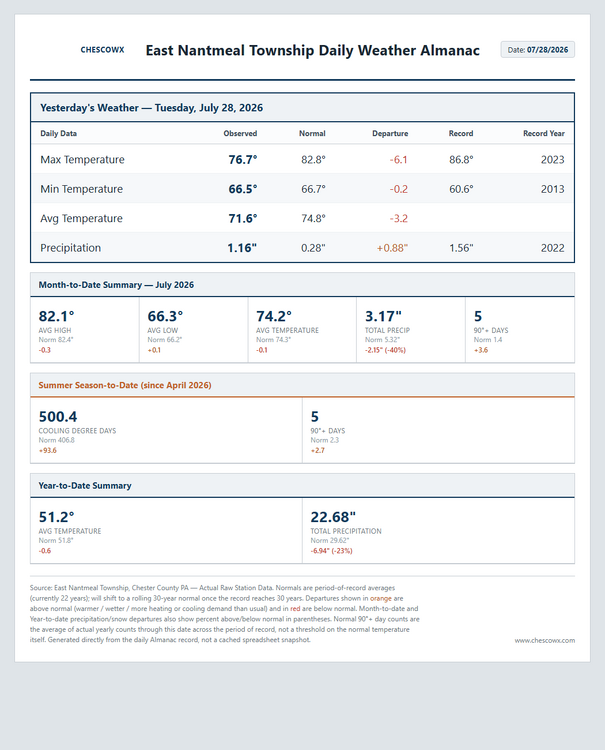
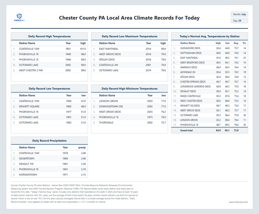
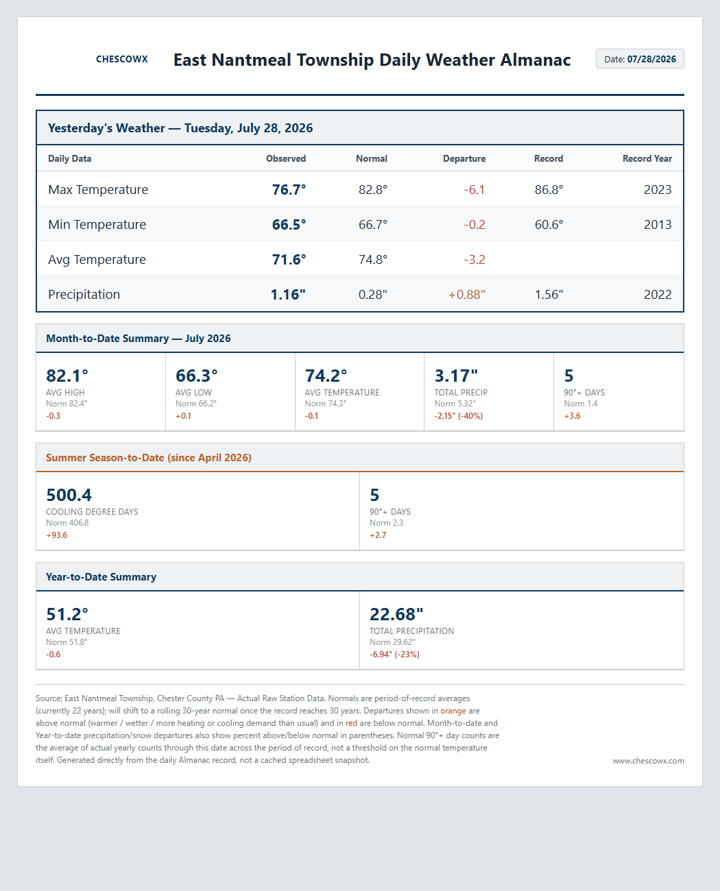
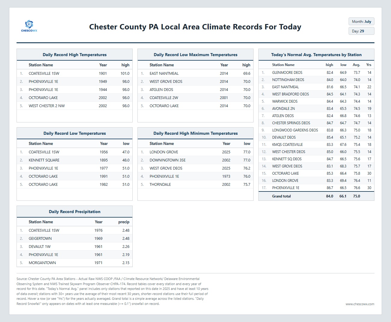
Our weather has trended nicer for much of the rest of the work week with below normal temperatures continuing through the period. OUr next rain chances look to arrive later Sunday and into the start of the new work week.