All Activity
- Past hour
-

Central PA Summer 2026 Discussion/Obs Thread
Superstorm replied to Voyager's topic in Upstate New York/Pennsylvania
Little taste of fall this morning. . -
Beautiful outside. 57F
-
 get cheap clomid without dr prescription: HormonePath - reputable overseas online pharmacies
 -
Upper 50's morning of July 20th not too bad.
- Today
-
While there is typically relatively high uncertainty for nascent, not well defined systems, I agree with NHC and posters here that the uncertainty here is unusually high due to the forecast coast-parallel track and the strong dependence of the track later this week on how quickly future Bertha gets organized in the next day or two. I go into the potential scenarios and all of the details here: https://hurricanehacker.substack.com/p/tropical-storm-bertha-likely-to-form?r=etzas
-
Day 2 ENH up
- 1,174 replies
-
- 2
-

-
- severe
- thunderstorms
- (and 7 more)
-

E PA/NJ/DE Summer 2026 Obs/Discussion
LVblizzard replied to PhiEaglesfan712's topic in Philadelphia Region
The NAM and HRRR look drastically different for Tuesday. The NAM has widely scattered storms in eastern PA while the main line stays in western PA and dissipates as it reaches this area. The HRRR plows a strong line of storms through the region on Tuesday evening. It’s a decent setup without as many fail modes as Saturday…but we still need things to come together the right way. It’s not easy to get a severe outbreak around here. -
For the first time in 7 runs, the UKMET doesn’t have a TS from this: it dissipates in the NW GOM similarly to the prior run TROPICAL DEPRESSION 02L ANALYSED POSITION : 28.0N 84.9W ATCF IDENTIFIER : AL022026 LEAD CENTRAL MAXIMUM WIND VERIFYING TIME TIME POSITION PRESSURE (MB) SPEED (KNOTS) -------------- ---- -------- ------------- ------------- 0000UTC 20.07.2026 0 28.0N 84.9W 1009 23 1200UTC 20.07.2026 12 28.5N 85.5W 1008 22 0000UTC 21.07.2026 24 28.3N 85.7W 1006 27 1200UTC 21.07.2026 36 28.9N 85.6W 1005 32 0000UTC 22.07.2026 48 29.7N 86.1W 1005 31 1200UTC 22.07.2026 60 30.3N 86.8W 1008 28 0000UTC 23.07.2026 72 CEASED TRACKING NEW TROPICAL CYCLONE FORECAST TO DEVELOP AFTER 84 HOURS FORECAST POSITION AT T+ 84 : 28.5N 90.9W LEAD CENTRAL MAXIMUM WIND VERIFYING TIME TIME POSITION PRESSURE (MB) SPEED (KNOTS) -------------- ---- -------- ------------- ------------- 1200UTC 23.07.2026 84 28.5N 90.9W 1009 25 0000UTC 24.07.2026 96 28.7N 91.7W 1010 24 1200UTC 24.07.2026 108 28.8N 93.4W 1012 28 0000UTC 25.07.2026 120 CEASED TRACKING
-
Yeah July hasn't been bad other than that incredible heat wave to start the month. Pretty good that we're gonna end up with a near normal month despite that record early heat. I'm glad that we've gotten much more rain this month too.
-
 It was good to see Spain win but I would not count him out for 2030 just yet.
 -
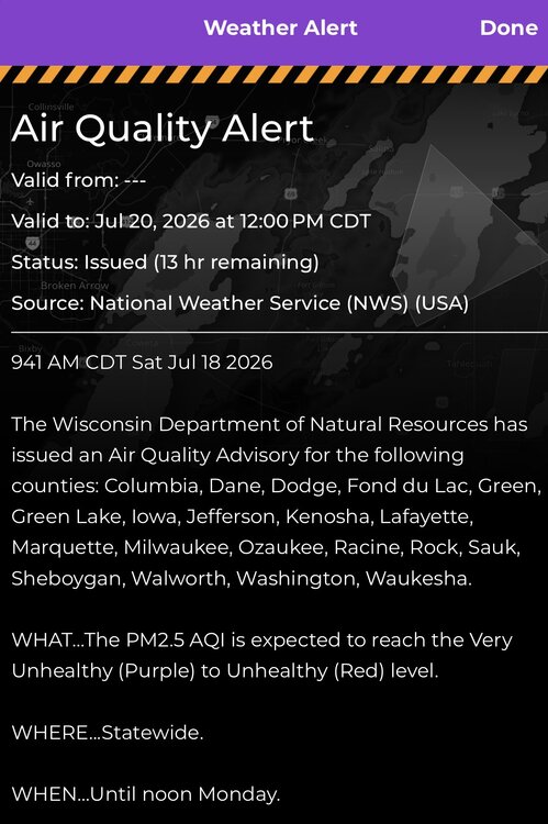
Welp here we go again
-
Oshkosh AirVenture could be interesting. Not like there’s 10s of thousands of people camping and thousands of planes that aren’t tied down properly. Hopefully they catch a break
-
Right, my point is that when the heat shows up it hits hard, but it otherwise has been bearable. After the heat broke on July 5th, I've only had 2 days that were 90+ and 2 days with a low of 70+.
-
I hope that TD2 now in the Gulf of Mexico tracks west right into south central Texas then gets stuck about 40 miles SW of Buda, then proceeds to pull in feeder bands of torrential training rains in off the Gulf for days. ESPECIALLY WHEN YOU CONSIDER HARDLY ANY MEANINGFUL GROUND DRYING WILL HAVE A CHANCE! Already, I have seen water catchment depressions carrying water all over the landscape!!!!!!!!!!! Yeah baby! We are going to have a BIG year for lots of rains in Texas!!!! I am a SICK PUP. But I crave a 50 degree Celsius El Nino. It's starting!
-

2026-2027 Super El Nino
40/70 Benchmark replied to Stormchaserchuck1's topic in Weather Forecasting and Discussion
Just brutal; the world stopped with the discontinuation of NCAR. -

2026-2027 Super El Nino
Stormchaserchuck1 replied to Stormchaserchuck1's topic in Weather Forecasting and Discussion
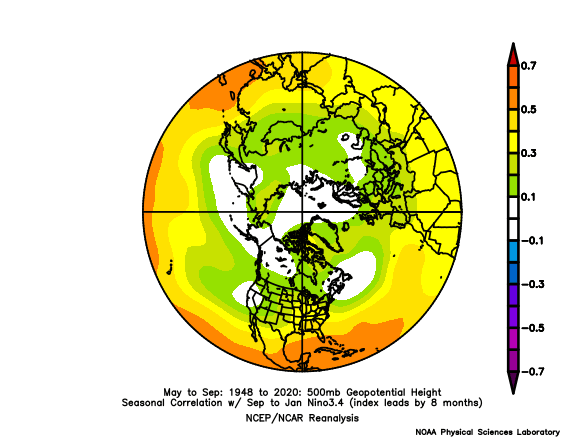
I am so curious to see what pattern we have over the Arctic next Summer after this Super, perhaps record breaking El Nino. The correlation with Nino 1+2 +time is fairly weak Nino 3.4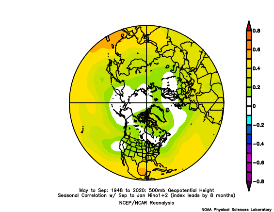
-

2026-2027 Super El Nino
GaWx replied to Stormchaserchuck1's topic in Weather Forecasting and Discussion
Thanks, Adam. For the period May-July, we’re likely headed to ~-22 avg SOI. One has to go all of the way back to 1905 to find any year at -22 or lower for May-July! Then it was -27. But that was a second year Niño (moderate). The only other one was in 1896, a strong Nino. That was at -28. Per Eric Webb’s tables, 1895-6 barely missed a low end weak Nino because there were only 4 tri-months in a row of +0.5 surrounded by +0.3s! So, 1896-7 was practically a 2nd year Nino. So, 2025-6 with 2024-5 having been La Niña is in uncharted territory going back to the mid-1800s as regards the extremely intense summer -SOI. -
We're top 5 warmest from june 1 through July 15 or half of met summer. The hot stretches have been record breaking and the smoke didn't help either. After a cooler spell in late July all signs point to a lot more record heat for early August. Humans are like goldfish when it comes to weather though
-
2026-2027 Super El Nino
Stormchaserchuck1 replied to Stormchaserchuck1's topic in Weather Forecasting and Discussion
What's the deal man? The stuff that we have access to is pretty basic and it discontinues lol. I actually miss the zoomed in CONUS radar they used to have available, a combination of all the radar sites. Now I can just look at the SPC overview threats radar. -
they were just so quick - the opposing team could never really string together a possession long enough to pose much of a threat.
-
Storms all around us but very little rain. Ended with just .05". Temp soared up to 97/83 for a feels like of 124 at around 1 pm then the storms came. Clouds and outflow cooled us to the low 80's.
-
2026-2027 Super El Nino
40/70 Benchmark replied to Stormchaserchuck1's topic in Weather Forecasting and Discussion
Yea, I know about that...but it doesn't have the monthly tabulations like this site (50mb): https://psl.noaa.gov/data/correlation/qbo.data And this one (30mb): https://psl.noaa.gov/data/correlation/qbo.data They stopped updating in February. -
81.5 today. 64 now.
-
2026-2027 Super El Nino
Stormchaserchuck1 replied to Stormchaserchuck1's topic in Weather Forecasting and Discussion
Probably >95% chance it's +QBO for the Winter. 15-16 was also a rare 2nd year Nino that went Super so maybe that could possibly have something to do with it? Closest multi-year Nino analog is 86-88 and that QBO was very uniform. -
The SPC outlook for tomorrow (7/20) has enhanced risk for wind in the upper Midwest, with 5% tornado outlook in Wisconsin. The 00z convection-allowing model runs have several scattered storms in Wisconsin and Iowa, with higher updraft helicity tracks