All Activity
- Past hour
-
As am I. Curious too if we have a late summer and into fall heat push, so maybe higher departures then.
-
Lots and lots of power outages around here. We
-
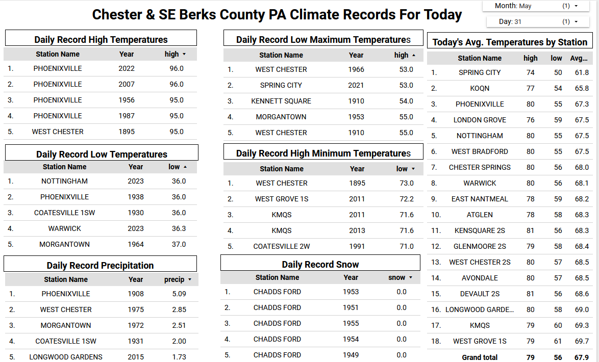
It looks like rainfall across the area ranged from as little as 0.48" at Atglen to as much as 1.51" at Devault. One more round of showers may cross the area late this afternoon and early evening with a strong cold front. We finally clear up tomorrow and begin a stretch of our best weather so far this spring. Most spots except the higher ridges should reach 80 degrees by Tuesday with low to mid 80's for all by Thursday.

-

E PA/NJ/DE Spring 2025 Obs/Discussion
ChescoWx replied to PhiEaglesfan712's topic in Philadelphia Region
It looks like rainfall across the area ranged from as little as 0.48" at Atglen to as much as 1.51" at Devault. One more round of showers may cross the area late this afternoon and early evening with a strong cold front. We finally clear up tomorrow and begin a stretch of our best weather so far this spring. Most spots except the higher ridges should reach 80 degrees by Tuesday with low to mid 80's for all by Thursday.
-
1.62 last 24 hours, 1.3 came in about 30 minutes yesterday. Fun facts from the my weather station. May 2025 had 2526 minutes of rain, or roughly 42 hours with 7.02” October 2024 had 32 minutes of rain with .06” of rain.
-
 DCA _ NYC _ BOS ___ ORD _ ATL _ IAH ___ DEN _ PHX _ SEA 1.6 2.2 2.3 2.6 0.2 0.8 0.4 1.3 0.5
 -
Not really a bust since the heavy rain was always going to be NW of our area. This was always going to be an under 1 inch storm for us. The sun coming out so early was a bit of a surprise, but it's awesome to have it most of the day. This is no *lull* either (I don't know why TV Mets use this stupid word, they're like robots), we're not going to be getting anything else today.
-
I knew it was going to bust. Had the feeling for days
-
1.3” for the event. Officially the wettest May in Harrisburg history.
-
Canada needs to change their flag from this, to this


-
Could add a little today with scattered showers/storms in the forecast.
-
5.2" for the month per my station. That's a little more than average for May.
-
The sun is in and out of the clouds overall it looks like a mostly rain free weekend for us.
-
Some heavy rain overnight. 4.41" for the day. Up to 12.51" for the month
-

2025 Lawns & Gardens Thread. Making Lawns Great Again
dendrite replied to Damage In Tolland's topic in New England
@Damage In Tolland
-
"last winter was cold"
-
partly sunny here after .56 of rain last nigh
-
Stats from Carlisle... Rainfall yesterday was 0.67". Overnight I recorded 0.11" for an event total of 0.78". Tentative total precip for May is 8.81" and YTD is 15.31". Low this morning was 54.7. Very low pressure for the end of May. My pressure bottomed out at 29.38" early this morning. The cold front has not reached us yet as the pressure has been steady all night, right around 29.41".
-
Probably about .4” on the Cape. We camp but we survive.
-
Tents are native. We let them live Gypsies we splat.
-
New City Rockland County checking in,,,,,we have outdoor activities today and It looks as if my area wont be outta the the rain woods until noon = do you peeps think there's a chance that this rain ends for good here In New City before noon or are we begging ? Imo the rest of the day afterward we will be able to get in
-
mm mentioned this yesterday but this thing is really sub-standard synoptic in scale. It's between meso and synoptic .. in Met we used to refer to that range as 'meso-beta' scaled. There's an intense rain ball over SE NY with warning headlines... and then these spokes like being on the east side of a tropical system racing N - meant as metaphor ...don't get your buns lubed with mustered. Anyway, the models appeared yesterday to be more spread out/interpretive over what was actually happening at the time, and so far that's translated up to being a more localized impact. One other aspect, we were commenting on the depth of the low pressure... I think this whole construct was misleading a bit... The low was developing in a region that was already 998 mb/negative regional anomaly with a broad surface trough in place. You take that initial condition and the low goes down 10 mb and suddenly you got something in the mid 980s... but it's really 1000mb low
-
Creek is still rising here. Gage height, feet Most recent instantaneous value: 4.55 05-31-2025 08:00 EDT
-
0.82” in the gauge this morning and my May CoCoRaHS total is 8.17”.
-

E PA/NJ/DE Spring 2025 Obs/Discussion
BBasile replied to PhiEaglesfan712's topic in Philadelphia Region
Ended up with 1.14" of rain. Makes it 6.97" for the month.