All Activity
- Past hour
-
Dont sleep on that little burst tomorrow night out this way.

-

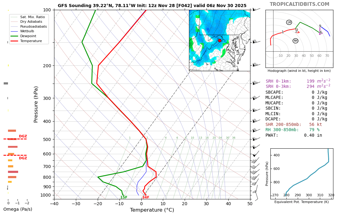
Nov 28-30th Post Turkey Day Wintry Potential
IWXwx replied to Chicago Storm's topic in Lakes/Ohio Valley
Crossing my fingers too. I saw your call and if it is onto something, you might have to bring your totals down a little, especially to the south and I would that for you (and me lol). But at least you have warned the public about possible last minute changes since we are riding the edge. So far IWX and you are in pretty good agreement though. -
Hard to lock anything beyond 72hrs now, sometimes not even a lock inside that anymore. The struggle is real.
-

Nov 28-30th Post Turkey Day Wintry Potential
Radtechwxman replied to Chicago Storm's topic in Lakes/Ohio Valley
Yeah the early morning through mid to possibly late afternoon look good here. Probably several hours of solid rates. But I would be shocked with a low track that north if we dont mix or switchover at some point. But good thing is here looks to happen towards end of the event when most of our accumulation is done already. This system doesn't have much of a deformation zone. -

2025-2026 Fall/Winter Mountain Thread
ncjoaquin replied to Buckethead's topic in Southeastern States
Welcome! -
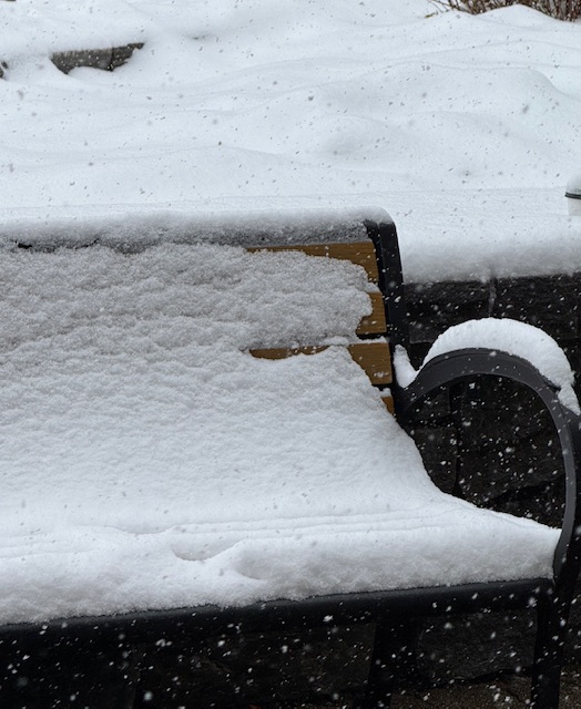
4” overnight plus today? Must be a sweet powder day. Its been snowing for a couple hours (1”/hr) and about 2” new today after 1” overnight. This is accumulations since about 9-10am in the base area.
-
Agree it looks good right now, but too close. I'm comfy betting on a NW trend in early Dec that depends on a cf penetrating into warmish ocean water and a baroclinic zone setting up offshore or near shore.
-

December 2025 regional war/obs/disco thread
H2Otown_WX replied to Torch Tiger's topic in New England
What are the temps like? -

December 2025 Short/Medium Range Forecast Thread
GBOVolz replied to John1122's topic in Tennessee Valley
PowellVols is in. Had to start a new account, new email . -

2025-2026 Fall/Winter Mountain Thread
Maggie Valley Steve replied to Buckethead's topic in Southeastern States
Welcome! Glad to have you in our great group of Mountain posters! May there be many 'Jebwalks' in your future! -
I'm betting he's at least 75% snow in this...probably all snow. Even the zonked GFS is like right on the line for him to be mostly snow.
-
GBOVolz changed their profile photo
-
Yep break out the shorts
-

December 2025 Short/Medium Range Forecast Thread
John1122 replied to John1122's topic in Tennessee Valley
GFS torched because it killed the MJO and headed it back kinda towards 6 in the COD. -
You in Btown? I don’t think I’d be as pessimistic there. Unless you really think this goes over RI or something.
-
It Fucking Sucks
-

Central PA Fall Discussions and Obs
Blizzard of 93 replied to ChescoWx's topic in Upstate New York/Pennsylvania
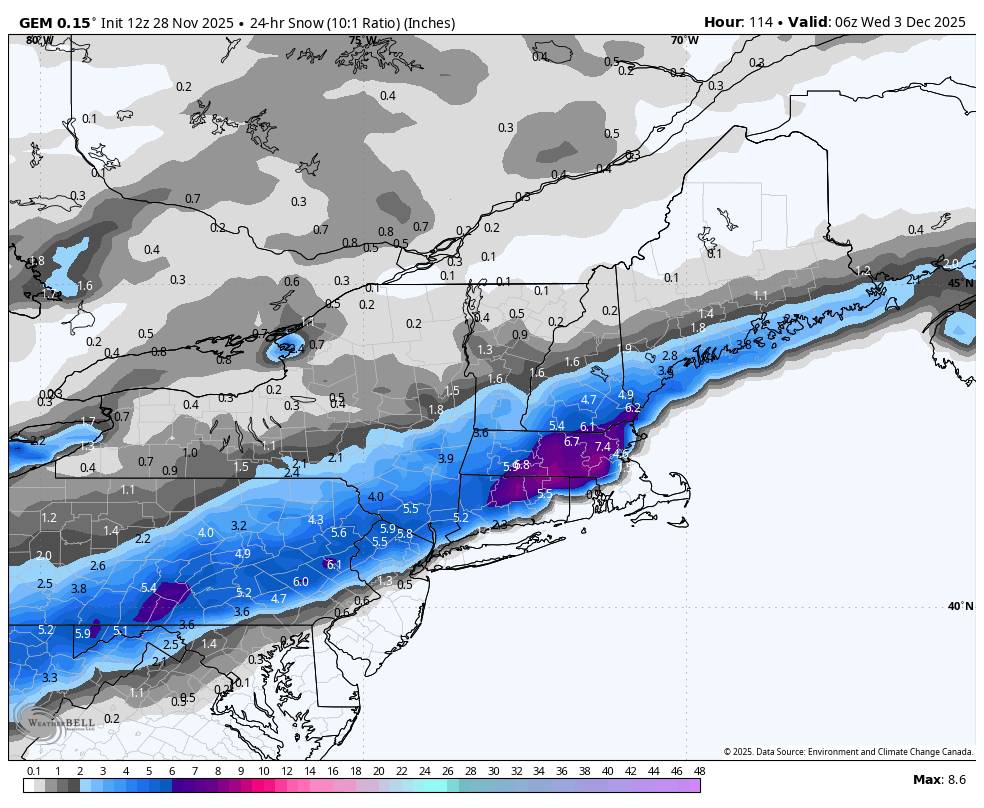
The 12z Canadian is a solid middle ground, similar to recent Euro runs. I would sign for this on Tuesday.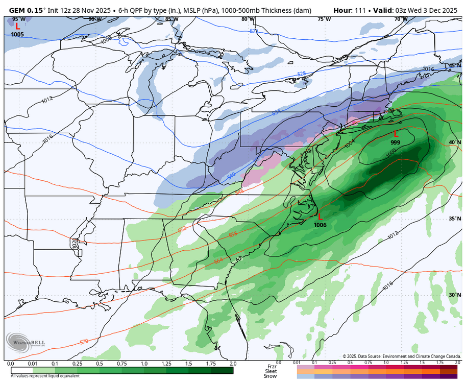

-
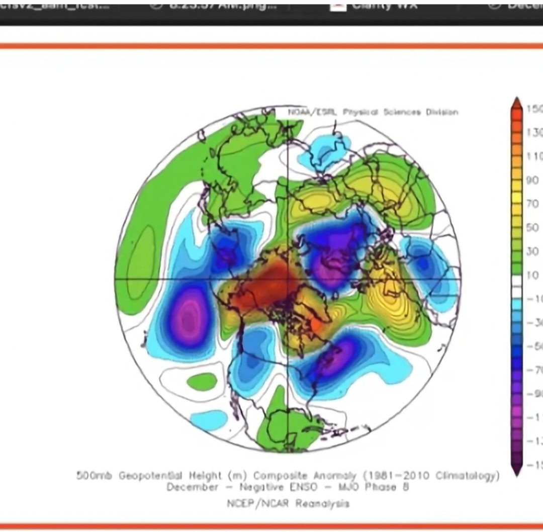
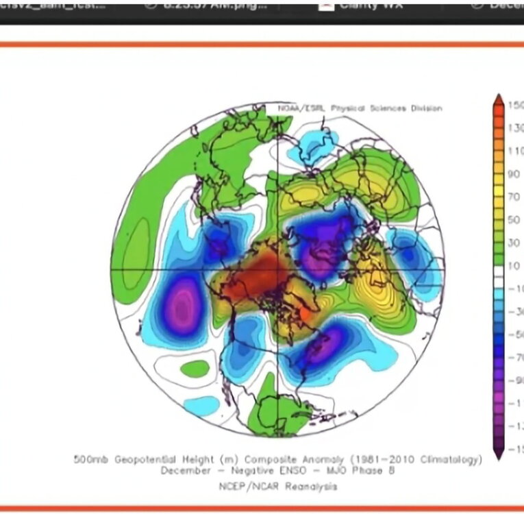
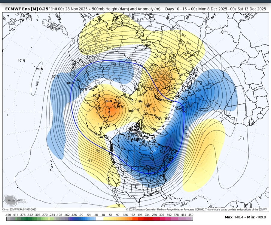
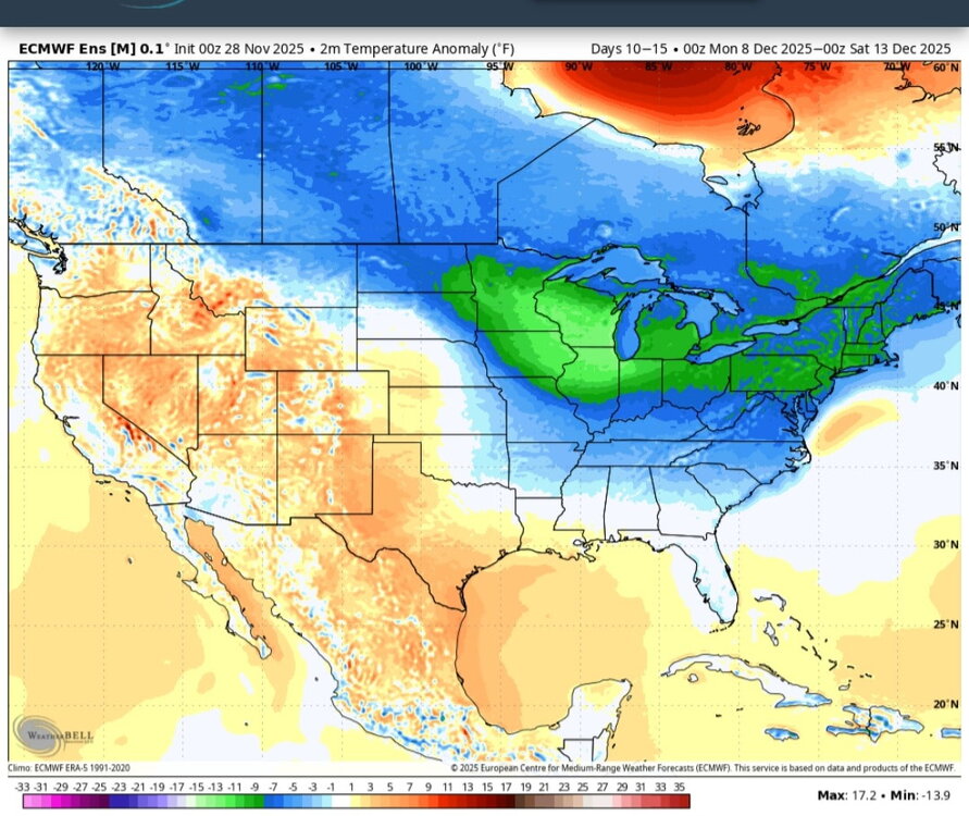
That’s a brutal phase 8 response
-

Nov 28-30th Post Turkey Day Wintry Potential
WxMatt21 replied to Chicago Storm's topic in Lakes/Ohio Valley
A bit strange to see such a dramatic reversal - it's on an island at this point. Even the ensemble isn't quite so drastic with the cut off. If some of the hi res guidance suggested something like this I would start getting concerned, but after seeing the 12z GFS/HRRR, as well as the 15z RAP, I don't think this run was the start of an overall trend. Crossing fingers -

Nov 28-30th Post Turkey Day Wintry Potential
Malacka11 replied to Chicago Storm's topic in Lakes/Ohio Valley
Wild how nonchalantly we stumbled into maps like this. Like Alek mentioned, the decent antecedent conditions for once is cool and something I'd willingly accept in lieu of better ratios later on.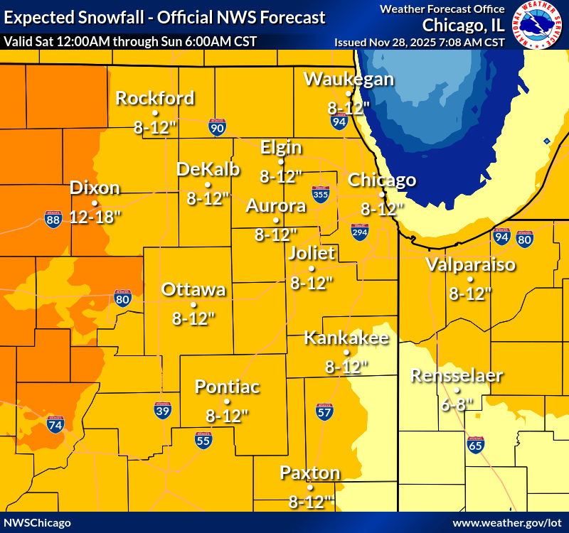
-

E PA/NJ/DE Autumn 2025 Obs/Discussion
LVblizzard replied to PhiEaglesfan712's topic in Philadelphia Region
My way too early guess for Tuesday. This looks like a classic Poconos jackpot type storm. 12z models so far have gotten slightly flatter/colder but I’m wary of them as the more north/amped solutions win more often than not with these types of storms. PHL: T TTN: C-1” RDG: 1-3” ABE: 1-3” MPO: 4-8” -
Honestly if Lamar is injured they should have been upfront with it, and left Huntley in. He played great in our biggest win of the season, against the 8-3 Bears. Lamar has 0TD in the last 3 games.
-
Not only do I expect this to be rain IYBY I expect it to be mostly rain IMBY too. So not really a homer post. Dendrite's scenario from a few mins ago would be perfect here and hope he's right. But we've seen a steady march NW from the suppressed nonsense a few days ago. NAM IMO will confirm eventually and climo is on the side of elevated interior event.
-
32 this morning
-

November 2025 general discussions and probable topic derailings ...
SJonesWX replied to Typhoon Tip's topic in New England
finished the last mow/leaf cleanup about 30 seconds before the squall hit. Still need to drop the winterizer, might have to wait until tomorrow