WxMatt21
-
Posts
116 -
Joined
-
Last visited


-

Nov 28-30th Post Turkey Day Winter Storm
WxMatt21 replied to Chicago Storm's topic in Lakes/Ohio Valley
Yeah, I noticed IWX has been pretty hesitant to use their NDFD output until recently! And wouldn't you know it, 12 ECMWF came in wetter/snowier, and in better alignment with the rest. Right now, I'm going to wait for the 18z NAM/HRRR to come in before making drastic changes, but my team is struggling with whether we want to keep things the same or up the totals since the consensus has been overwhelmingly snowy for most. My argument against is compaction, which could give off the impression we were dead wrong lol! Also, I'll be curious to know how well the NBM does when all is said and done. It has hardly budged over the past 48 hours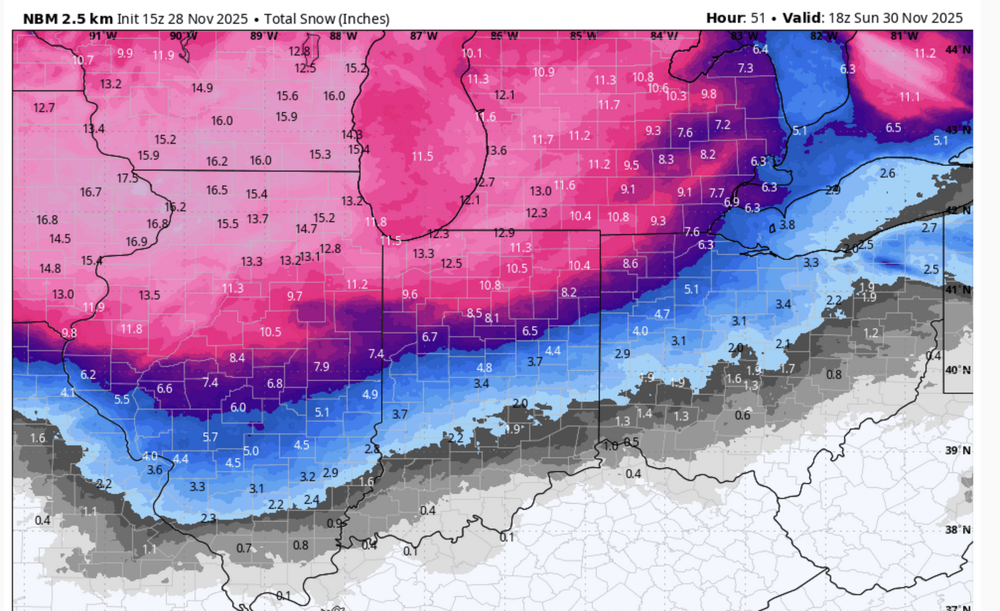
-
Nov 28-30th Post Turkey Day Winter Storm
WxMatt21 replied to Chicago Storm's topic in Lakes/Ohio Valley
A bit strange to see such a dramatic reversal - it's on an island at this point. Even the ensemble isn't quite so drastic with the cut off. If some of the hi res guidance suggested something like this I would start getting concerned, but after seeing the 12z GFS/HRRR, as well as the 15z RAP, I don't think this run was the start of an overall trend. Crossing fingers -
Currently 36 at FWA. Areas south and west/east of here all in the mid 30s. Expect some cooling as the heavy precip moves in, but it has been way warmer than modeled.
-
I was referring to surface wind/being able to take off
-
No updates! Says on time, so I guess we'll see. I feel like the thing I have going for me is a strong headwind. At least no t-storms will be in the vicinity! Crossing fingers...
-
I have a flight leaving BOS and headed NE to Edinburgh at 9 pm tomorrow Winds don't seem too out of control at that point, but I'm admittedly not as familiar with the sustained/gust threshold for commercial airlines and what qualifies for a delay or cancellation...
-
Spring 2023 Medium/Long Range Discussion
WxMatt21 replied to Chicago Storm's topic in Lakes/Ohio Valley
Sunday the 25th at 12z. Of course, model consistency is severely lacking, so take that, as well as anything else, with a huge grain of salt. -
According to Chief Met Tom Coomes (ABC57 in South Bend), this is just for Wednesday. He didn't feel comfortable adding in Thursday's totals yet.
-
Interesting blog post from Judah Cohen about the late spring and early summer pattern
-
FWA and surrounding areas quite a bit colder than modeled thanks to clearing. Think HRRR has the right idea. 0Z NAM has FWA getting into the upper 30s Thursday afternoon, but it also had us at 24 by midnight. We're 16 right now. 00z HRRR has us getting to 33/34, it had us modeled at 19 by midnight. This colder solution will obviously translate to a better shot at getting more snow than rain. Still expecting about 1-2" here, though wonder if we could see an overachiever.
-
Thought that was odd...interested in their reasoning. Seems there's more than enough support for a warning almost 24 hours out.
-
Not to mention some of the op solutions I've seen (looking at you, NAM) are just outright laughable for NE IN...like, way beyond climatology and approaching, or in some cases shattering, all-time snow records. Never say never, I suppose, but ensembles showing a swath of 5-7" is far more realistic for this area than anything over 10". I don't regret not issuing a snow map today. But hey, if this thing ends up overachieving, I'm here for it all the same!
-
Oh, I was just commenting about northern Indiana, particularly NE where we don't get much lake action. Both ice and snow have been exaggerated in recent memory on the euro, but clearly that's not the case everywhere!
-
Well, the most recent one was the ice event on New Year's Day. Euro consistently had 0.50"+ of ice accretion not only days ahead of the event, but on the day itself! Then the December 2nd event where the Euro painted a stripe of 7"+ for Northern Indiana about a day or two leading up to the event. We ended with about an inch.
-
I can name at least three systems just this winter that were pegged as big dogs on the Euro (even a day or two out!) for NE Indiana only to fizzle into sloppy, wet, utterly forgettable snow showers. Of course, I live in Fort Wayne, IN, a place where storms come to die a swift and painless death.


