
snowman33
-
Posts
72 -
Joined
-
Last visited
About snowman33

Recent Profile Visitors
2,332 profile views


-
Nov 28-30th Post Turkey Day Winter Storm
snowman33 replied to Chicago Storm's topic in Lakes/Ohio Valley
Maybe? -
Nov 28-30th Post Turkey Day Winter Storm
snowman33 replied to Chicago Storm's topic in Lakes/Ohio Valley
Climo wise, this time of year you'd expect these systems to cut hard and drop heavier snows across the Great Plains. I can't recall seeing a setup just like this in a long time with the antecedent trough over the Great Lakes. -
11/8-11/10 First Snow and Lake Effect Event
snowman33 replied to Geoboy645's topic in Lakes/Ohio Valley
Can't fathom what is happening, been burned too many times with LES. -
11/8-11/10 First Snow and Lake Effect Event
snowman33 replied to Geoboy645's topic in Lakes/Ohio Valley
The recent HRRR runs have the main band stationary over Lake County, IL. Gets O'Hare into the heavier totals. -
Fall/Winter '24 Banter and Complaints Go Here
snowman33 replied to IWXwx's topic in Lakes/Ohio Valley
As a snow weenie guess I'm just gonna have to move to Florida to get those big time snows. /s -
As we have seen, the game isn't over until the clock hits 0.
-
Already has my dude, it's called the greenhouse effect.
-
Winter 2024-25 Medium/Long Range Discussion
snowman33 replied to michsnowfreak's topic in Lakes/Ohio Valley
GFS has been consistently showing a clipper signal 11/30-12/1. Hoping I can see some football in the snow that weekend. -
Morning and evening sun with some gentle thunderstorms and small hail in the afternoon. Top shelf day.
-
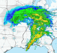
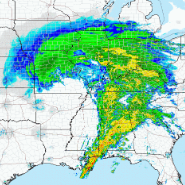
Looking at the depth change map, it seems like areas farther north in Wisconsin get screwed more, possibly due to a longer fetch over the warm water. Temps in downtown Chicago when the 1st wave starts are still near/at freezing.
-
Lakefront peeps like meet the new storm, same as the old storm.
-
1-3" on the lakefront, rising to 6-10" inland seems like a good bet.
-
NAM north/amped.
-
It'll be historic all right... a historic paste job.
-
12/26/09 is an event that comes to mind that had an extreme gradient through the Chicago metro.


