All Activity
- Past hour
-

September 2025 OBS-Discussion centered NYC subforum
qg_omega replied to wdrag's topic in New York City Metro
Pattern still looks very dry next few weeks -
I think they very well could still win the division. But they clearly aren’t able to compete against other playoff caliber teams.
-

September 2025 OBS-Discussion centered NYC subforum
SnoSki14 replied to wdrag's topic in New York City Metro
Endless summer with 80s deep into October -
59/59....gosh i don't think I have washed my car in awhile, boy we need rain, hope we all cash in.
-

September 2025 OBS-Discussion centered NYC subforum
bluewave replied to wdrag's topic in New York City Metro
Very rare occurrence this August and September. Several stations are on track for a colder August monthly minimum temperature than in September. First time at Allentown since 1982. Looks like a warmer pattern to close out the month. Monthly Lowest Min Temperature for Trenton Area, NJ (ThreadEx) Click column heading to sort ascending, click again to sort descending. 2025 49 50 49 2024 52 45 45 2023 57 50 50 2022 58 41 41 2021 58 49 49 2020 58 40 40 Monthly Lowest Min Temperature for PHILADELPHIA/MT. HOLLY WFO, NJ Click column heading to sort ascending, click again to sort descending. 2025 48 49 48 2024 51 44 44 2023 54 49 49 2022 57 44 44 2021 59 49 49 2020 58 40 40 Monthly Lowest Min Temperature for SOMERSET AIRPORT, NJ Click column heading to sort ascending, click again to sort descending. 2025 44 46 44 2024 48 40 40 2023 52 45 45 2022 53 37 37 2021 53 45 45 2020 54 34 34 Monthly Lowest Min Temperature for Allentown Area, PA (ThreadEx) Click column heading to sort ascending, click again to sort descending. 1986 41 38 38 1934 41 43 41 1927 42 40 40 1982 43 47 43 1976 43 38 38 1944 43 38 38 1940 43 34 34 2025 45 47 45
-
3 straight days of MRGL per SPC... today through Thursday
-
What a torch overnight.
-

Central PA Summer 2025
Mount Joy Snowman replied to Voyager's topic in Upstate New York/Pennsylvania
Low of 64. Let the rain cometh. -
This is what they do . Glad you all made it out ok
-
lol
-

September 2025 OBS-Discussion centered NYC subforum
wdrag replied to wdrag's topic in New York City Metro
Glad it worked out despite off by 4 miles on storms... and much thanks for the followup review (including dance)! -
Dews up hoes down right thru the weekend
- Today
-
Dews out there.
-
wtf glad you’re safe. Wow.
-
The Ravens OL is mediocre at best without Ricard, and who knows when he will back. Another one of those vague/mysterious injuries when Harbaugh is asked about his status.
-
Thru 3 games, the Ravens D is dead last in ypg allowed, 2nd to last in passing yards per game allowed, 3rd to last in rushing ypg allowed, and 2nd to last in ppg allowed. Pretty sure no one expected that thru 3 games even with the front loaded schedule. Im not a ravens fan, so obvs take this fwiw, but I wouldn’t freak out. The schedule eases going into October and the north isn’t going to be great this year with Burrow being out and the Steelers looking pedestrian again. This is still a team that can go far in the playoffs.
-
 Iluvsubvortexs joined the community
 -
It's now rained about all night long. Thankful for it, as leaf and fire season approach.
-
Picked up some much needed rain. Anywhere from .22 to .30” 65 degrees…’ fishing in my league this morning.
-
Yeah, Gabrielle is cranking. Should help a little with the low seasonal ACE numbers if it can hold onto major hurricane status for a few days.
-
45 this morning in Stockholm. Yesterday’s high was 60. Today’s looks to be 55. We hired a boat for an archipelago tour. Stll not a drop of rain for this trip. I think I am cursed.
-

Plains States Observations and Discussion Thread
andyhb replied to lookingnorth's topic in Central/Western States
Locally significant tornado threat possible over NE OK and NW AR tomorrow, in the vicinity of a modifying outflow boundary from tonight's MCS along the OK/KS border. -
 0Z Euro has a 1006 TS hit NC 9/29
 -

2025-2026 ENSO
Stormchaserchuck1 replied to 40/70 Benchmark's topic in Weather Forecasting and Discussion
I would think warmer water in the Gulf of Alaska and Bering Strait would be a cause of more arctic ice melt, which is more +PDO... but the arctic ice melt has completely gone bare on the Pacific side of the Arctic circle, and the PDO has gone to new record low levels during and after that time, so something may be connecting them.. although maybe not directly -
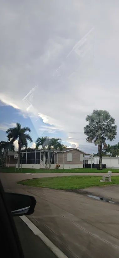
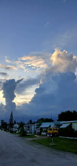
And so it did. For a couple of hours in the early afternoon, weak flow aloft created mostly stationary thunderstorms over the southern FL peninsula. The image as follows is a few hours later, around sunset. Eventually, storms grew over downtown FLL just east of here (opposite direction of pic below) and delivered around 1.5-2" of rain with great lightning.

-
 We Love Cats and Kittens joined the community
 -
In theory, a -QBO should destabilize the tropical tropopause and cause a stronger, more robust MJO and on equator forcing/convection. Maybe this erratic behavior with the westward propagations and weak, low amplitude MJO waves is only temporary and will change as we go deeper into fall? Strong -IOD/La Niña playing a role? I’m honestly not sure besides saying to take a wait and see approach