All Activity
- Past hour
-
An extended period of cool weather is now underway. This morning, the temperature slipped to 49° in Central Park. That was New York City's coolest temperature this month. The below normal temperatures could persist into early next week. A general 0.50"-1.50" rainfall is likely tomorrow into Thursday. A gusty wind will likely accompany the rainfall. Showers could persist into Friday. There is a chance that New York City could see the mercury dip below 50° Thursday or Friday. The ENSO Region 1+2 anomaly was 0.0°C and the Region 3.4 anomaly was +0.1°C for the week centered around May 7. For the past six weeks, the ENSO Region 1+2 anomaly has averaged +0.55°C and the ENSO Region 3.4 anomaly has averaged -0.07°C. Neutral ENSO conditions will likely continue through at least mid summer. Early indications are that summer 2025 will be warmer than normal in the New York City and Philadelphia areas. The potential exists for a much warmer than normal summer (more than 1° above normal). The SOI was +0.09 today. The preliminary Arctic Oscillation (AO) was -0.511 today. Based on sensitivity analysis applied to the latest guidance, there is an implied near 53% probability that New York City will have a cooler than normal May (1991-2020 normal). May will likely finish with a mean temperature near 63.1° (0.1° below normal).
-
We definitely busted high today, I was hot working outside moving stone. Usually it seems like we're lower than advertised though, we're at 3k ft elevation on the nose.
-
With the best intentions, two arms make all the difference. As always ….

-
Just imagine... One minute you're doom scrolling your way down the road and then next thing you know not only do you need at bare minimum a new windshield but a camera crew is there recording your ass. Still beats dying ig
-
It hasn’t looked very impressive since it got into the mesos range.
-

2025 Short Range Severe Weather Discussion
mob1 replied to Chicago Storm's topic in Lakes/Ohio Valley
Bismarck IL looks to have taken a hit from a confirmed tornado. -

2025 Spring/Summer Mountain Thread
Met1985 replied to Maggie Valley Steve's topic in Southeastern States
Tornado watch will be hoisted up this evening for WNC per Jason Boyer. - Today
-
The incoming system is affected by blocking HP over E. Canada, but it is riding a little too far north for a soaking rain.
-
1.90" since yesterday. We definitely needed it.
-
My latest freeze is May 31st (1984), so there is always a chance......
-
Just wait for that downsloping blowtorch in another month or so. Back to desert for you.
-
Showers have made it to DLH. Winds around the head of the Lake peaking 50-60+. Park Point & Duluth Harbor seeing the gusts of 60+. High wind warning issued today. 40+ up my way under wind adv.
-
haha this spring sucks. Might as well just skip summer this year
-

2025 Short Range Severe Weather Discussion
SchaumburgStormer replied to Chicago Storm's topic in Lakes/Ohio Valley
Nice little couplet in ford county working its way north -
Went to work in just shorts and my short sleeve shirt, no jacket. Was regretting the decision until about noon, then happy I made that choice.
-
nah... Don't let the gloom light of the day along with the negative temperature anomaly sway one's impression of May. It's quite a bit above normal this month, with several days near or even exceeding 80 F - so it wasn't just the lows this time ... With actually a lower cloud anomaly. This is no April. In fact, it's almost an insult to those that hate April for legitimacy to have to accept this month as being anything like what they've suffered all those wretched ass violating Aprils of the past. Lol clear enough?
-
It’s almost time for Tip’s annual nape post…for next year
-
Storm blew through earlier. Now it's sunny, hot and humid as all get out. Don't know if we are still in a favorable supercell environment or not. I assume so with the tornado watch.
-
Maybe slightly from a few days ago. Still looks like a general inch or so for much of the region with more in the higher terrain to the west, and any places that happen to get under some convection tomorrow.
-
I’ve heard some also — Brood XIV https://www.washingtonpost.com/nation/2025/04/24/cicadas-2025-brood-xiv-maryland-dc/?utm_campaign=wp_post_most&utm_medium=email&utm_source=newsletter&carta-url=https%3A%2F%2Fs2.washingtonpost.com%2Fcar-ln-tr%2F4242211%2F680bb3621e3c794918561e64%2F64fddbb854ee7d10a3e01f06%2F17%2F56%2F680bb3621e3c794918561e64 https://www.goodhousekeeping.com/life/a64795778/cicada-map/
-

2025-2026 ENSO
Stormchaserchuck1 replied to 40/70 Benchmark's topic in Weather Forecasting and Discussion
Importance of the +PNA for coastal low tracks bluewave Low's hug the coast in that pattern. CPC says it was +PNA, but the 500mb maps don't show that. We didn't have that piece in February. We had that piece in Feb 2016, and somewhat Feb 2014 (but it was much more -WPO in Feb 2014). WPO air temp correlation in Feb (opposite) - +200dm anomaly overpowered and kept Feb 2014 cold. +NAO was also further east - -200dm over England in Feb 2014. This one was closer to us. -
This is why our springs have gotten cooler (high temps) and a -nao has become prevalent in April and May while a +nao is prevalent in the winter now.
-
At least this will be gone before Memorial Day weekend. From the maps I've seen there may even be some sunshine tomorrow morning and the sun may come out again Friday afternoon.
-
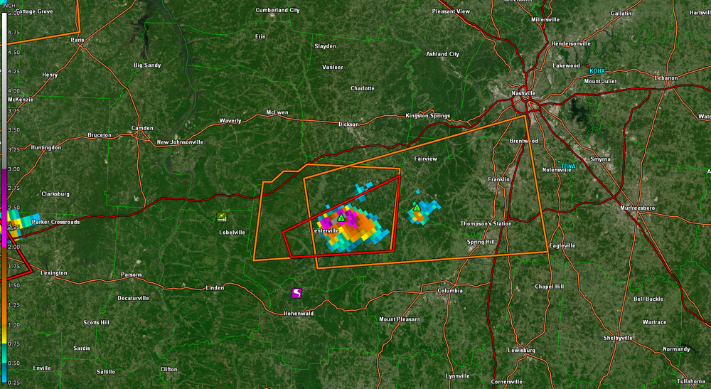
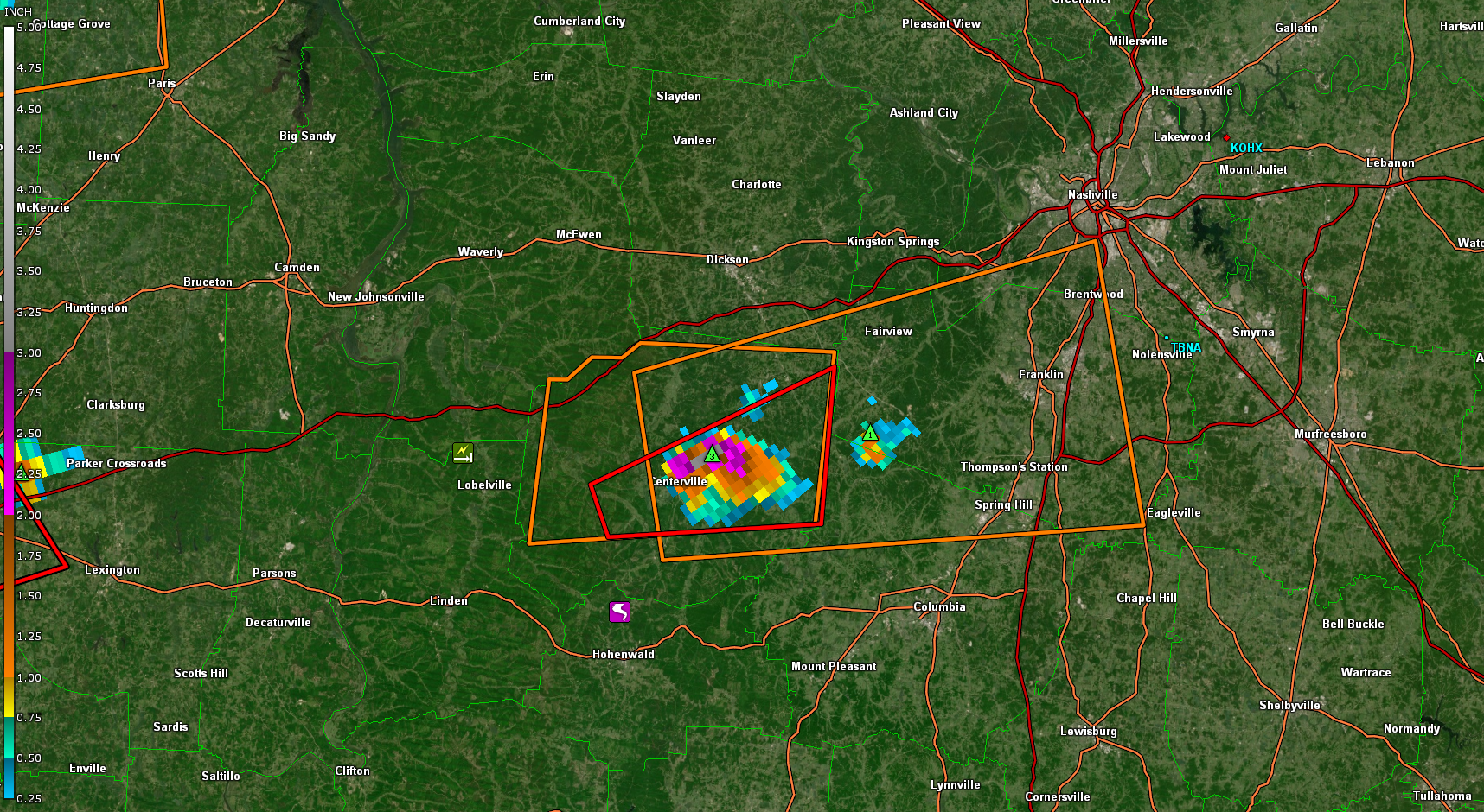
Some big hail ,the Centerville cell