All Activity
- Past hour
-

2026-2027 Super El Nino
40/70 Benchmark replied to Stormchaserchuck1's topic in Weather Forecasting and Discussion
Yea, RONI measures the associated mid latitude response relative to what is expected per ENSO climo....ie while one aspect of el Nino (Canadian ridge) may be well expressed, another be less so (Aleutian low), thus the RONI will still lag the ONI. Again, not to be redundant, but it is our innate proclivity as humans to be too binary with these concepts in our thought process. -
Dec 92 was a whiff at Gardiner, where we then lived - clouds, wind (thousands of white ash seedlings that spring) but no flakes. March 01 is the 2nd snowiest (55.5") of any month I've measured, trailing only the 61.5" of Dec 1976 in Fort Kent. The early month big dog was almost 20 hours of steady 0.5"/hr snow on 20-30 mph wind, but the capper was the pair of post-equinox storms that totaled 35" and boosted the pack to 48" on the 31st, deepest I've seen that late in the season. Another even stronger storm had been forecast for 4/1, but it went east and crushed Newfoundland.
-
mesoanalysis showing over 4ksbcape in n il this afternoon
-

2026-2027 Super El Nino
bluewave replied to Stormchaserchuck1's topic in Weather Forecasting and Discussion
Yeah, there is an overlap going on so the line where one starts and the other ends may not be that clear. All the mid-latitude ridges between 30N and 60N have been getting stronger regardless of El Niño or La Niña. So perhaps that’s why the Aleutian low and mid-Atlantic and Southeast lows during recent super El Niño events have been getting weaker than in the past. Plus the weekly to seasonal guidance has been missing this ridge expansion in their long range forecasts. So we keep getting all these near to 10°+departure warm months close to the core of the ridges that aren’t being forecast beyond 15 days. -
So effing boring
-
0.10”. Which brings me to 0.10” on the month.
-
First 70-degree dewpoint of the year. Booo!!
-
Right now it looks like a strong El nino but models have been wrong in the past. Also maybe hes talking about this upcoming winter. I dont like bashing meteorologists even if they are wrong. He did bust badly last winter.
-
Pretty decent steady rain over here at Coppin State
-

Central PA Summer 2026 Discussion/Obs Thread
mahantango#1 replied to Voyager's topic in Upstate New York/Pennsylvania
yea, we don't need hail. -

2026 Mid-Atlantic Severe Storm General Discussion
Eskimo Joe replied to Kmlwx's topic in Mid Atlantic
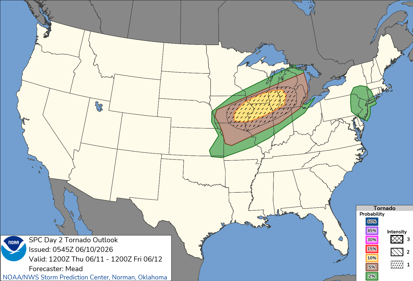
SPC introduces Slight Risk for Thur and Fri. Personally I'd favor Friday for more widespread convection. -
Central PA Summer 2026 Discussion/Obs Thread
mahantango#1 replied to Voyager's topic in Upstate New York/Pennsylvania
-
The truth is usually a blend between INS and DIT.
-

Junorch obs and discussion 2026
Damage In Tolland replied to Damage In Tolland's topic in New England
Stein really has us now. Sucking the life out of everything thru the weekend -
Wow! Down here in the severe drought region we're watching it dry up on radar as it approaches. My area lost its hot hand from last July.
-
.41” that was not expected.
-
Cancelled my WaPo subscription yesterday, looking forward to watching you guys branch out and grow
-
Congrats NYC again.
-
2026-2027 Super El Nino
40/70 Benchmark replied to Stormchaserchuck1's topic in Weather Forecasting and Discussion
Yea, I have come to learn that RONI really isn't a great indicator of strength, but rather a measure of the degree to which other hemispheric forces (usually CC induced during the modern era) are competing with ENSO. Ultimately, the answer as to whether the ONI or RONI is of greater utility is more nuanced than the majority of those among weather circles perceive it as being, which is often the case. In reality they both seem to have some value. -
Miserable commute in. Saw two vehicles go off the road.. My garden appreciates the rain at least
-

Central PA Summer 2026 Discussion/Obs Thread
Voyager replied to Voyager's topic in Upstate New York/Pennsylvania
Not liking that Thursday outlook. I don't want hail. Been there, done that, had a damaged car that proved it when it happened. -
overnight d2
- Today
-
-
.20 this morning
-
Nice rain showers overnight and currently. Approaching .10. Grass will survive another week. edit: .21 at 7:08am