All Activity
- Past hour
-

January 2026 regional war/obs/disco thread
dendrite replied to Baroclinic Zone's topic in New England
Oh lol. I was just getting excited for his next snowfall event. -
I'm afraid that will be the best Euro run we see. Guidance is already shifting north with it. Hopefully the south west trend will pick back up later..
-

Winter 25/26 General Obs
Holston_River_Rambler replied to Holston_River_Rambler's topic in Tennessee Valley
@Carvers Gap Kingsport looks like it is about to get a decent squall. -

January 2026 regional war/obs/disco thread
CoastalWx replied to Baroclinic Zone's topic in New England
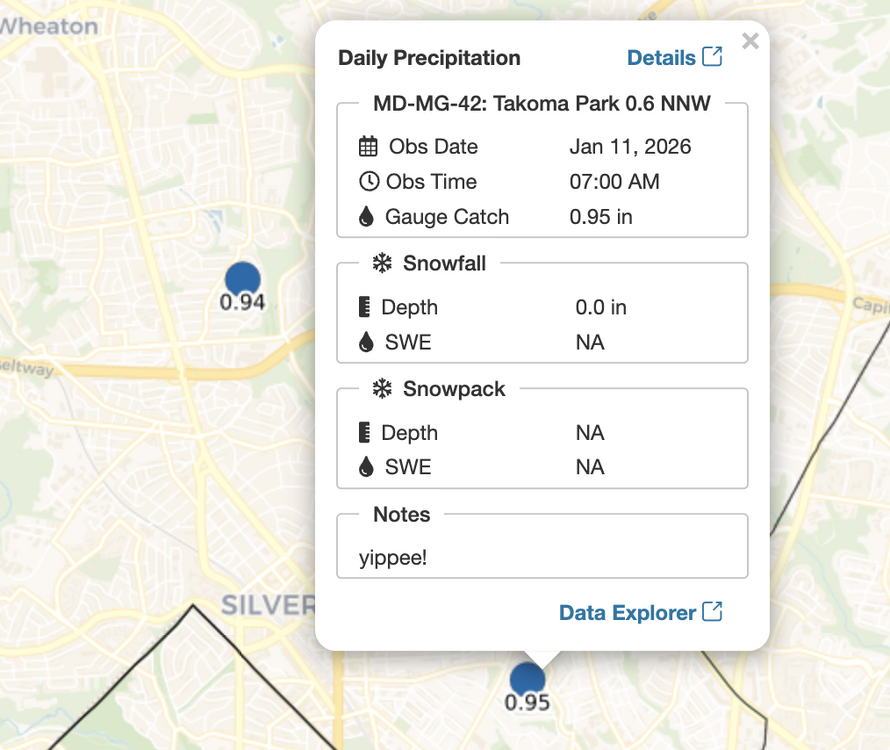
You mentioned 2” from .10 QPF. I think we both thought you were reporting what fell last night. -
.55” yesterday
-
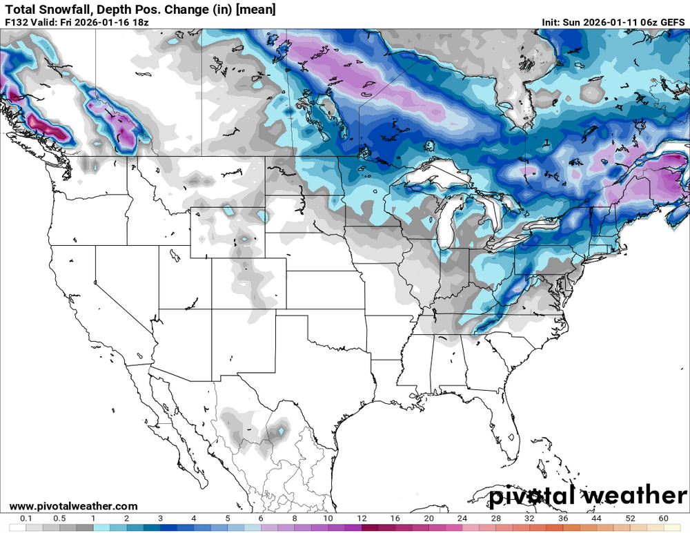
43 / 40 0.70 inthe bucket last night. Should see clearing and sunshine around noon or so. Overall above normall till Wed. Trough into the east / Ridge balloons and colder / below normal by the 16th.. Still have storm potential Jan 15 - Jan 19 or so or is it mainly dry. Beyond there still looks to edge below normal overall.
-
This is still pinned. Idk it could be a generic hoping to see a squall thread
-
Can one of the mods put a weenie tag next to the title of this thread?
-

January 2026 Medium/Long Range Discussion
NorthArlington101 replied to snowfan's topic in Mid Atlantic
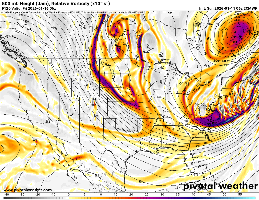
I feel like we’ve learned a fair bit about the character of this threat last night. GFS and EURO outcomes at 6z really aren’t that far apart, even in terms of distance. Storm has maybe a 6-8” max for those perfectly in its crosshairs but otherwise it’s gonna be pretty standard despite the awesome h5 look. We’re praying for the deform to cash in and missing all of the WAA. Tricky. -
January 2026 regional war/obs/disco thread
dendrite replied to Baroclinic Zone's topic in New England
2” from what? -
The GEFS and EPS are still an open wave frontal boundary evolution. The very early mid level cut off over the southeast is just a potent meso vort traversing the boundary. It doesn’t allow for a bend back or strengthening of the already diffuse BZ… So on top of all the limitations—you’re not gonna get the mid level magic out of this either.
-
1.67", went outside this morning to let the dog out in rain and sleet
-
-
Lots to like in that overnight guidance. The Euro op has quite a bit of support as well. It’s been a while since we’ve had a Manitoba Mauler. Just a little more digging south and west and boom!
-
It’s kind of cool that there’s so much uncertainty. Given the persistent weak solutions, I would have to think it will be weak. But sometimes these things have a way of returning to what they were showing initially. Probably the second system is going to be better. The CPC flagged that potential a couple of days ago and if it’s a swfe it’s probably a lot less complicated
-
i share the sentiments from the notes by my nearest cocorahs reporter.
-

Winter 2025-26 Short Range Discussion
Baum replied to SchaumburgStormer's topic in Lakes/Ohio Valley
Stick to weather. Something you know. There your observations are spot on 25% of the time.
-

Pittsburgh/Western PA WINTER ‘25/‘26
TimB replied to Burghblizz's topic in Upstate New York/Pennsylvania
Looks like the line might kinda split those of us in or near the city. Oh well. -
Yeah agree. When I see this consolidated, beefy vort swinging NE I wouldn’t think it’s going to get stretched out like Gumby 6hr later. I mean, maybe it has the right idea, but I wouldn’t put my eggs in that solution basket yet.

-

January 2026 regional war/obs/disco thread
moneypitmike replied to Baroclinic Zone's topic in New England
I just saw that someone started a thread for the 15th.......... -
Heck of a way to run a +PNA
-

E PA/NJ/DE Winter 2025-26 Obs/Discussion
BBasile replied to LVblizzard's topic in Philadelphia Region
Ended up with 1.66" of rain. -
The GFS upgrade back in 2019 caused it to incorrectly forecast KU snowstorms at times when there was no other model support. This problem still hasn’t been addressed since it may just be an inherent model bias. We are coming up on the 1st anniversary of its 964mb benchmark blizzard that never occurred last January 12th which the Euro forecast correctly showed was a GFS model error. https://www.wired.com/story/the-governments-new-weather-model-faces-a-storm-of-protest/ For the past few weeks, the National Weather Service has been forecasting snowfall that ends up disappearing, according to Doug Kammerer, chief meteorologist at WRC-TV in Washington, DC. “It’s just not performing well,” Kammerer says. “It has continued to show us getting big-time snowstorms in this area, where the European model will not show it.”
-
That really was PD2 and then some. 2’ down and way more to come lol.
-
You got as much rain in 24 hours as we’ve had last 4 months combined