All Activity
- Past hour
-
They broke out the ice breaker too...

-
Clouds are moving in here.. it was nice here today though
-

Central PA Spring 2026 Discussion/Obs Thread
pasnownut replied to Voyager's topic in Upstate New York/Pennsylvania
Just give me a run of the mill T boomer please n thx. Dont like damaging anything stormwise. -
Well I went to my usual source for some DFH 120s, but they were all gone. Picked up some GI BCBS. Been a long time since I've had it. 2025 version, and damn good.
-
Storm over El Paso looking like it may be the first interesting one of the day. Shame I have a sick kiddo and couldn’t make the trip today, as that’s where I was planning on posting up
-

March 10th, 2026 Severe Threat
HillsdaleMIWeather replied to pen_artist's topic in Lakes/Ohio Valley
70/60 probs for TORs -
High of 68° today but back down to 49° with the clouds. Because even on the sunniest days, somehow the clouds find the upper Valley. The DP‘s are going to take their toll so I’m guessing I’ll be down too 50% snow pack by Thursday. Probably about 90% right now.
-
looking for an hour 240 snowstorm....
-
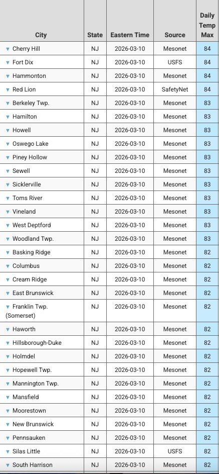
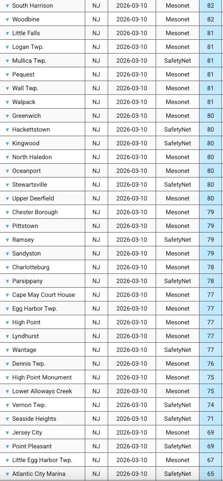
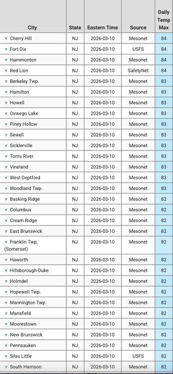
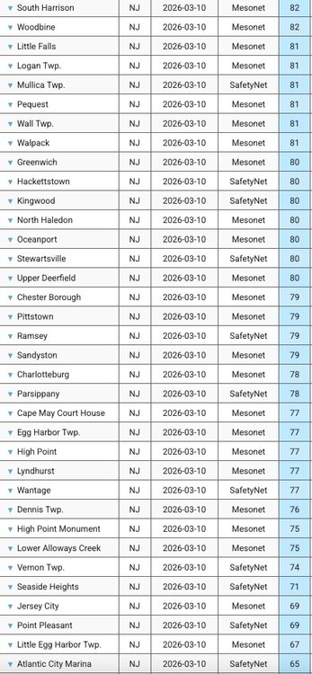
Max temps across NJ today: (click images to enlarge)
-
After a high of 80 today the peepers are loud and proud.
-
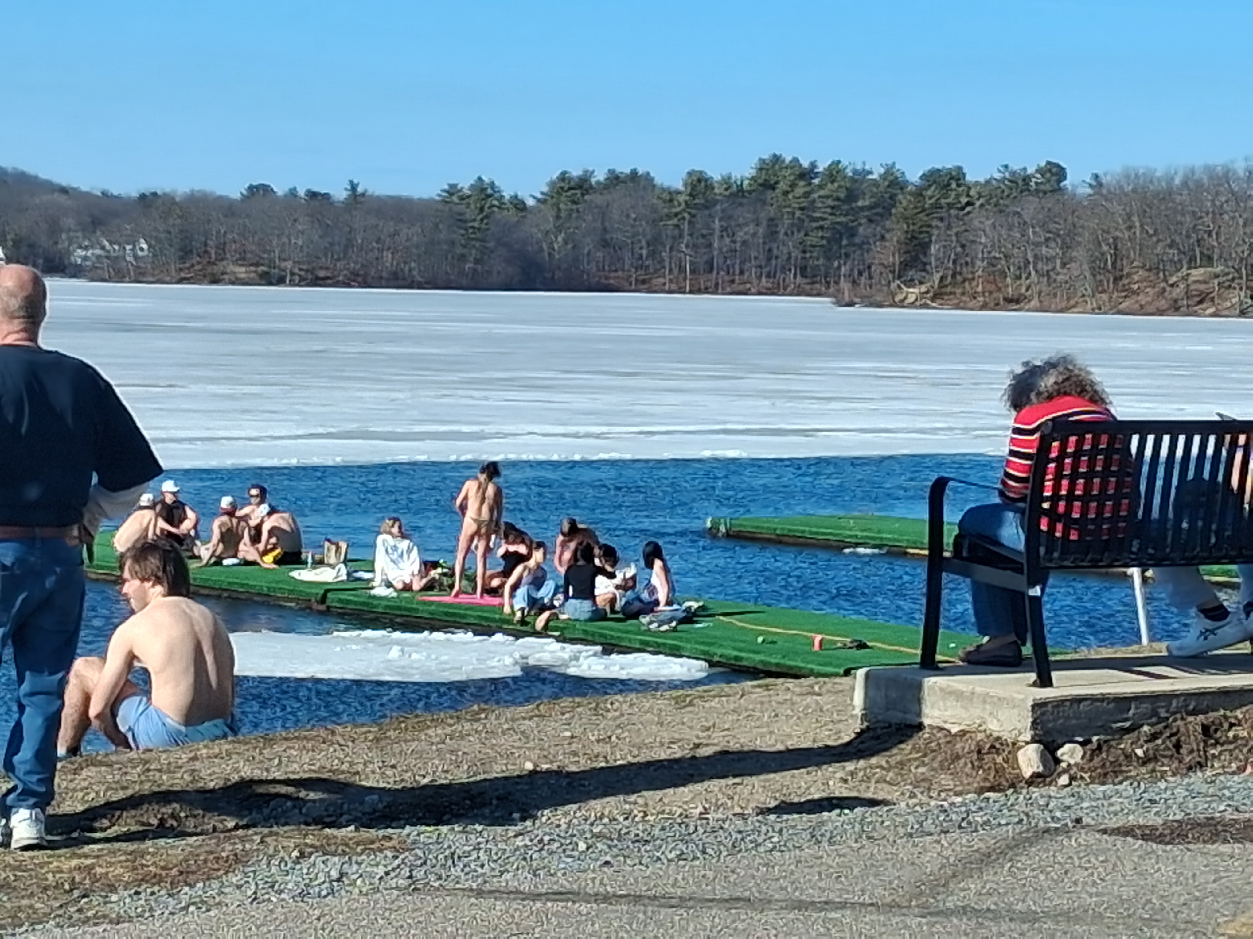
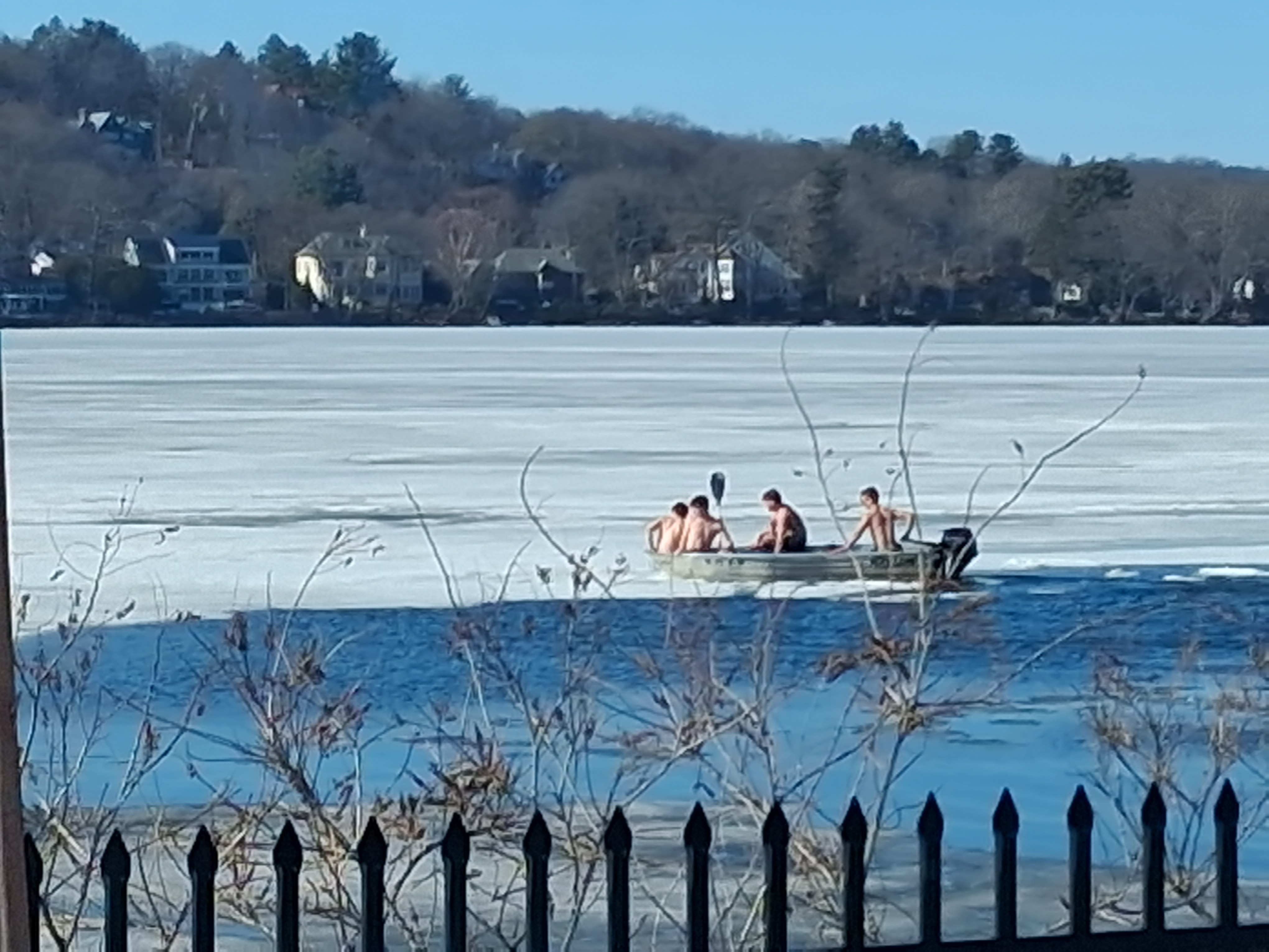
Tufts kids enjoying the beach day on the mystics

-
By 3 days. They hit 85 on 3/13/1990. Their 78 on Feb 21, 2018 might be even more anomalous, but today is only the 15th day they've reached 80 or warmer in the month of March, POR from 1/1/1869 so it's March #157 there.
-
March 10th, 2026 Severe Threat
HillsdaleMIWeather replied to pen_artist's topic in Lakes/Ohio Valley
Would expect the watch any minute now -
Man, once any of these get their feet into the BL and locked it could get scary. The ventilation is crazy good. Look for one to hang a hard right. Somebody gonna get smacked. Hopefully just a cow
-
Looks like IAD will do it too for 85F...they've at least tied the earliest for 84F.
-
Full cover here still
-

2026 Mid-Atlantic Severe Storm General Discussion
high risk replied to Kmlwx's topic in Mid Atlantic
Yeah, I like the 2% hatched. It reflects that there right now is an overall low threat of tornadoes in this area, but if we were to get one, it could be a strong one. -
Amazing what strong mixing with a warm low-level airmass can do coupled with WAA ongoing in the low levels as well.
-
2026 Mid-Atlantic Severe Storm General Discussion
high risk replied to Kmlwx's topic in Mid Atlantic
Yeah, that was impressive. I agree that there is a lot of uncertainty, but there does seem to be some consensus that the best shot at storms and severe weather tomorrow is north of I-66 in VA and Route 50 in MD. And the real threat might be another county north. -
Cold yes but really just two one day cold snaps and nowhere near as impressive as what’s been going on with this heatwave! We have set 3 record highs, 2 record high minimums already and tomorrow the point click has been upped to 89. We had 88.5 this afternoon here, which was nearly 6 degrees above the forecast and 7 above the RDU record! For the piedmont looks like Friday morning will be around freezing and one night around freezing and one night in the upper 20s next week before it warms up. Hardly a historic event, but a significant shock after this stretch of summer in early March. If RDU hits 90 tomorrow it will be exactly 2 months before average, as the average first 90 reading of the season is May 11… RAH commented that this weather and heights are more typical of early July!
-

E PA/NJ/DE Spring 2026 Obs/Discussion
JTA66 replied to PhiEaglesfan712's topic in Philadelphia Region
Doors and windows open, 76F in the house. -

2026 Mid-Atlantic Severe Storm General Discussion
batmanbrad replied to Kmlwx's topic in Mid Atlantic
The latest forecast for me (Gaithersburg) STILL has no mention of severe for tomorrow, doesn't mention thunder at all! I checked the point-and-clicks for several other cities/counties in our area... nada. -
Crash and burn ineedsnow
-
come visit us in the severe thread!
-
Earliest 84F ever for BWI.


.thumb.png.4150b06c63a21f61052e47a612bf1818.png)