All Activity
- Past hour
-
Kalshi has NYC over/under 71 today. What side are we on? lol
-
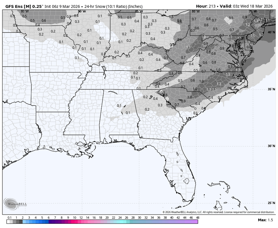
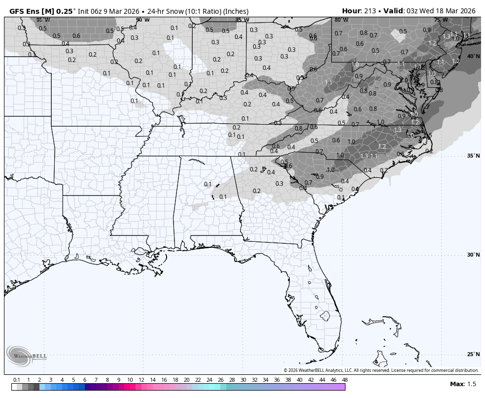
6Z GEFS clown mean for St. Patrick’s Day at 10:1:
-
Except for basements, lol
-
If things continue as progged, may buzz down to El Paso or somewhere nearby tomorrow and see how things develop.
-

Central PA Spring 2026 Discussion/Obs Thread
pasnownut replied to Voyager's topic in Upstate New York/Pennsylvania
Lol'in at the back and forth with the its over..... no....it's not this met is waving his flag, so it must be.... Its been cold, must welcome the warmth. Friendly reminder to all sans bias.... 1. It's over when Mo Nature says so. Always has been always will be. 2. Like it or not, plenty of signs have been showing for the St. Pattys period for shenanigan's. Doesn't mean snow, but it'll be a kick in da arse cold compared to the spring fling we all are about to enjoy. 3.Even those of us who love snow and cold. Yesterday was nice to be outside. That's undeniable no matter how big a sno hound one can be. 4. Someones "ex" favorite met tossed some weather cookies of his own and blew some events (due to his bias, or just getting the call flat wrong?) 5. It's March 9. Mets and maps have all been wrong enough this year for me to discount nothing. Last weeks ens guidance said winter was over whle Ops said hold my beer. Look where we are a week later. PLENTY of cold/snow showing up. 6. for those anxiously waiting for spring warmth, you can wish it on all you want but that wont change the date on the calendar. Your time is coming but for your sanity's sake, tug back on the reins a bit. Ok....carry on. -
Torching today! Let's get rid of these filthy snowpiles today
-
We still have one. Although the kids yesterday in the neighborhood were doing their best to knock the crap out of it. Daffodils are getting there. Can see the flower heads starting to come out of the leaves. And wow what a change in my morning mood with the sun. 45 currently.
-
Amazing that we’ll be able to melt out without experiencing any flooding anywhere. That’s the way to do it.
-
Quickly up to 51 here
-
Daylight 11:h38M Gained 2H23M since the lull Roughly equivalent to October 3rd Gaining a peak of 2M40+s daily
-
Big temperature differences from the valley to the hills.
-

E PA/NJ/DE Spring 2026 Obs/Discussion
JTA66 replied to PhiEaglesfan712's topic in Philadelphia Region
We were told there would be no historic spring blizzard reaching an extinction level event along the I-95 corridor but didn’t listen! Instead, we ran around like a bunch of cotton-headed-ninny-muggins’ gassing up snow blowers, hitting the grocery stores and itching to start a thread. When will we ever learn our lesson to not trust models post 300 hours?? -
Thankfully, though the front month of crude is still up sharply from Friday (~10-11%), some sanity has returned relative to where it was at its 119 peak near 10:30PM last night as it has fallen back to the low 100s. Later months hadn’t been up nearly as sharply based on the feeling that crude won’t stay up more than a relatively short period. Once crude finally does start settling down and falling back, the ever-present challenge of retail following through will be there as they love spiking their prices quickly and reducing them back much more slowly.
-
This time the trough is a little too sharp and just sends the low flying up the Great Lakes. NNE perhaps could grab something on the front end.
-
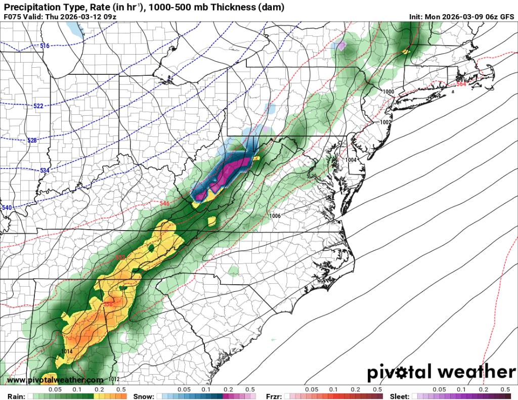
Looks like Thursday we could see a line of severe storms come through early in the morning then possibly some flakes on the back end of this cold front. Sent from my SM-G998U using Tapatalk

.thumb.jpg.db5b88d83797c454fbe88396cc78ae6b.jpg)
-
Here’s The big takeaway…this always happens as we approach the mid range…the models lose the system either out to sea, or it turns into a cutter, or gets shredded. This is no different. Each time this year they’ve come back. The pattern supports a storm, that’s the important part. We will see where this heads over the course of this week. signal is there. Anybody who thought the models wouldn’t deviate from 8-10 days out was fooling themselves. This loss of the system was coming…it always does. Maybe this time it doesn’t come back, it’s as good a possibility as any, but we don’t know that yet. See where it stands come the end of the week…and that’s a ways out.
-
Was a good run, but when it's over it's over.
-

Central PA Spring 2026 Discussion/Obs Thread
Mount Joy Snowman replied to Voyager's topic in Upstate New York/Pennsylvania
Low of 37. Amazing couple of days coming up here. -
Records: Highs: EWR: 82 (2016) NYC: 77 (2016) LGA: 75 (2016) JFK: 67 (1973) Lows; EWR: 10 (1996) NYC: 11 (1996) LGA: 14 (1996) JFK: 13 (1996) Historical: 1891: From March 9 through the 13th, a blizzard struck southern England and Wales with gale-force winds. 220 people were killed; 65 ships foundered in the English Channel, and 6,000 sheep perished. Countless trees were uprooted, and trains were buried. Up to a foot of snow and snowdrifts of 11.5 feet were reported in Dulwich, London, Torquay, Sidmouth, and Dartmouth. 1922: Dodge City, KS set its all-time 24-hour snowfall record as 17.5 inches fell. (Ref. Wilson Wx. History) 1943: The temperature at Lac Frontiere, ME fell to -40°. This is the coldest ever March reading in New England. Further south, Baltimore, MD recorded a high barometer reading of 30.96 inches of mercury (Ref. Wilson Wx. History) 1948: Blizzard conditions of 9th-10th (and resultant snow cover) whitened much of KS. All-time KS March record cold of -25 °F in Oberlin, Healy and Quinter on the 11th as a result. March records of -15 °F (Dodge City) and -3 °F Wichita) also on 11th. (Ref. Weather Guide Calendar with Phenomenal Weather Events 2012 Accord Pub. 2011, USA) 1956 - A whopping 367 inches of snow was measured on the ground at the Ranier Paradise Ranger Station in Washington. The snow depth was a state record and the second highest total of record for the continental U.S. (The Weather Channel) 1960 - A winter storm produced a narrow band of heavy snow from north central Kentucky into Virginia and the mountains of North Carolina. Snowfall amounts ranged from 12 to 24 inches, with drifts up to eleven feet high in western Virginia. (David Ludlum) 1987 - Gale force winds ushered arctic air into the north central U.S. Some places were 50 degrees colder than the previous day. Northeast winds, gusting to 60 mph, produced 8 to 15 foot waves on Lake Michigan causing more than a million dollars damage along the southeastern shoreline of Wisconsin. (The National Weather Summary) (Storm Data) 1988 - A cold front brought high winds to the southwestern U.S. Winds in the Las Vegas Valley of Nevada gusted to 70 mph, and one person was injured by a falling tree. (The National Weather Summary) (Storm Data) 1989 - Twenty-two cities in the southwestern U.S. reported new record high temperatures for the date. In New Mexico, afternoon highs of 72 at Los Alamos, 76 at Ruidoso, and 79 at Quemado, were records for March. (The National Weather Summary) 1990 - Evening thunderstorms produced severe weather in West Texas. Thunderstorms produced wind gusts to 71 mph at Lubbock, and golf ball size hail was reported at several other locations. Strong thunderstorm winds injured two persons north of the town of Canyon. (The National Weather Summary) (Storm Data) 2013: A supercell over eastern Oahu in Hawaii produced 4.25" hail NW of Kailua, the largest hailstone ever recorded in Hawaii. The storm also spawned a tornadic waterspout that came ashore and caused EF-0 damage.
-
"Yuuuup"
-
Looks on vis loop like terrain induced, then venting down stream. Probably just needs the sun to work on the tow source and then it will dry out?
-
42 / 41 and sunshine. The first mostly sunny day in over a week and 70s for many away from the coast. Same Tuesday and Wed is a matter of timing the arrival of the front / clouds. Showers and light rain possible overnight Wed into Thu. Cooler but drier beyond there and into this coming weekend 13-14-15. Much chillier next week with the potential late winter storm - likely a north and New England focused one. A bit back and forth by the 21st and overall near to above avg to close the month.
-

2026 Mid-Atlantic Severe Storm General Discussion
dailylurker replied to Kmlwx's topic in Mid Atlantic
LNFG!- 23 replies
-
- 1
-

-
- severe
- thunderstorms
- (and 7 more)
-
Perfect maple weather last night... Cold, then recovering for a sunny mild afternoon. My sis lives on 40 acres up in Winchendon and says the sap's flowin' Buckets are drippin good flow rates. Despite the impression of still biology out there, life is showing signs.
-
Ya the AI went to crap..might be the end for some.


.thumb.png.4150b06c63a21f61052e47a612bf1818.png)


.jpg.fbea87da110e2e2ff5442e35443a4e6b.jpg)


