All Activity
- Past hour
-

Richmond Metro/Hampton Roads Area Discussion
RVASnowLover replied to RIC Airport's topic in Mid Atlantic
Yeah given how this system went, definitely too early to get excited about the next potential threat -

January 2026 regional war/obs/disco thread
40/70 Benchmark replied to Baroclinic Zone's topic in New England
I'm talking reality, not long range model runs...but that isn't high-end, anyway....nice storm, but not anything epic. -

E PA/NJ/DE Winter 2025-26 Obs/Discussion
Ralph Wiggum replied to LVblizzard's topic in Philadelphia Region
That would make the Sunday system look like preschool. Who's starting the thread? -
Cold pattern and we can do here is rain.
-

Possible Record Breaking Cold + Snow Sunday 1/25 - Tuesday 1/27
jm1220 replied to TriPol's topic in New York City Metro
That stretch from Dallas/Waco to S VA will have devastating ice in some places for sure. And no power for a week or more. -

Possible Record Breaking Cold + Snow Sunday 1/25 - Tuesday 1/27
psv88 replied to TriPol's topic in New York City Metro
I definitely think most of the island mixes for 2-3 hours before a flip back. Still a full day for ticks either way, but I would bank on some sleet -

MO/KS/AR/OK 2025-2026 Winter Discussion
JoMo replied to stormdragonwx's topic in Central/Western States
Depends on how cold the lower atmosphere profile is. Most models have the calculations built in, but it does sometimes overestimate. -
January 25/26 Jimbo Back Surgery Storm
audioguy3107 replied to Jimbo!'s topic in Southeastern States
Some of the shorter term models are now showing barely any precip in north Georgia at all until the system passes off to the east.....it's almost impossible to believe after the model runs we've seen the last few days but here we are. -
That storm on the GFS op has a ridiculous band of SN from MSY to ATL to CLT and then on up the coast. 12" of snow in MSY (the 06Z also had this, a year after they had their record snowfall; maybe we should all move to Bourbon Street), 2-3 feet on ATL (record is 8"). We manage 1-2' up here. Would be wild.
-

Possible Record Breaking Cold + Snow Sunday 1/25 - Tuesday 1/27
Prue11 replied to TriPol's topic in New York City Metro
Central Suffolk north of LIE -
January 2026 regional war/obs/disco thread
40/70 Benchmark replied to Baroclinic Zone's topic in New England
Yea, no thanks. -

January 2026 regional war/obs/disco thread
Sey-Mour Snow replied to Baroclinic Zone's topic in New England
-

January 2026 regional war/obs/disco thread
Ginx snewx replied to Baroclinic Zone's topic in New England
Unless of course it redevelops and stall after getting a jolt of upper air energy. FWIW Tips say back to back storm are rare 2011 2015 is knocking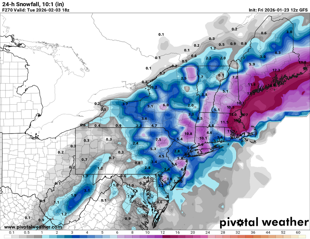
-
Yep, over a week of NW model trend tendencies to endure. The model bias too cold /too far SE vs reality has just occurred with these last 2 storms and is a never ending/common occurrence as most here should know by now.
-
January 2026 regional war/obs/disco thread
40/70 Benchmark replied to Baroclinic Zone's topic in New England
-

Snow Contest January 25th-26th
Stormlover74 replied to WeatherGeek2025's topic in New York City Metro
New York City 8.3 Boston 14.4 Philadelphia 6.8 Washington DC 6.3 Hartford 15.8 Albany 19 -
I think they too may see more sleet than FZRA though they're on the border I think of where things setup on the FZRA/sleet line
-

Jan 24-26 Weekend Snow and Sleetfest Model Thread Part Tres
mappy replied to H2O's topic in Mid Atlantic
Honestly people should focus on qpf and apply their backyard climo to get idea of totals. Snow maps are lol -

January 24-26: Miracle or Mirage JV/Banter Thread!
eaglesin2011 replied to SnowenOutThere's topic in Mid Atlantic
That’s a real boneheaded thing to say.. Your “losing interest “ in a storm that could change how half the country operates for at least a week. The time it’s flipping has nothing to do with the (time of day ) it’s the upper air that is moving in… Hell nobody really knows what will exactly happen happen yet .lol -

MO/KS/AR/OK 2025-2026 Winter Discussion
MUWX replied to stormdragonwx's topic in Central/Western States
Fairly sure its an estimated ratio based on the thermal profile, but not confident. Historically its pretty over done, but its a little more accurate in a super cold environment than 10-1 is. -
Thinking the biggest risk is the transfer of energy to the coastal low.
-

January 25/26 Jimbo Back Surgery Storm
neatlburbwthrguy replied to Jimbo!'s topic in Southeastern States
Do you think Dunwoody could get any sleet or mostly all freezing rain? -

January 2026 regional war/obs/disco thread
Prismshine Productions replied to Baroclinic Zone's topic in New England
hr240, s/w over Wisconsin was diving Sent from my SM-S166V using Tapatalk -

January 2026 regional war/obs/disco thread
sankaty replied to Baroclinic Zone's topic in New England
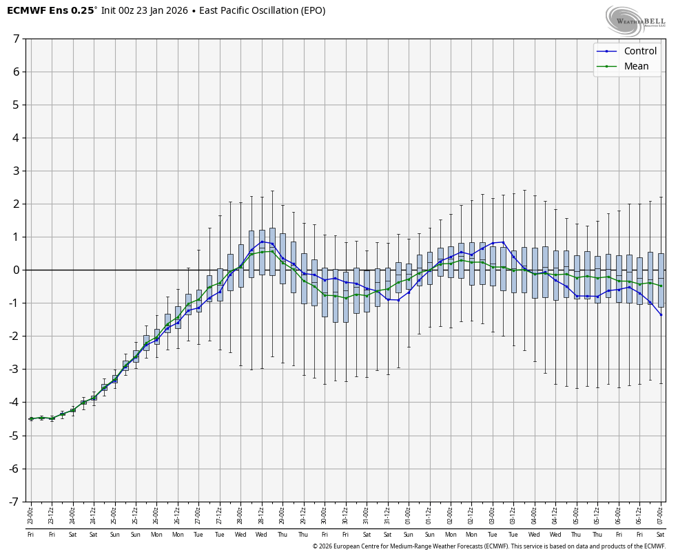
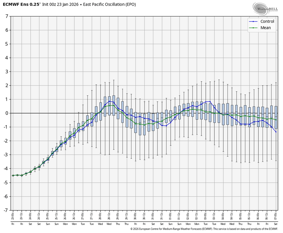
Anyone have a link that shows the EPO index forecast? Thanks. -
Sunscreen kidding aside, we have a former NWS guy at our church. Long retired. He told me 15 years ago this area was probably one of the most difficult areas to forecast in North America.