

LakeEffectOH
-
Posts
362 -
Joined
-
Last visited
About LakeEffectOH

Recent Profile Visitors
3,347 profile views


-
It's been wild all of 2026!
-
I was driving to work at the time. Must've had the radio up too loud...
-
Just heard at the office that it could have been a meteor. BTW, you should be getting hammered now under that stationary snow band.
-

2025-2026 ENSO
LakeEffectOH replied to 40/70 Benchmark's topic in Weather Forecasting and Discussion
I wonder if next winter's El Nino is going to be more like a La Nina. -
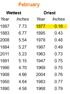
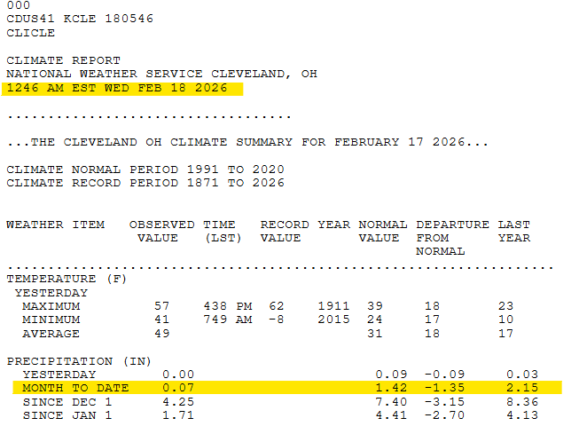
So far this month, precipitation at CLE has been abysmal. Only .07" has fallen to date and forecast QPF/precip chances keep going down...down...down. Could be the driest Feb on record at CLE or easily the 2nd driest.
-
Winter 2025-26 Medium/Long Range Discussion
LakeEffectOH replied to michsnowfreak's topic in Lakes/Ohio Valley
So far this month, precipitation at CLE has been abysmal. Only .07" has fallen to date and forecast QPF/precip chances keep going down...down...down. Could be the driest Feb on record at CLE or easily the 2nd driest.
-
2025-2026 ENSO
LakeEffectOH replied to 40/70 Benchmark's topic in Weather Forecasting and Discussion
Yes it is... -
OHweather, what happened to cause the snowflakes to not be so good?
-
Updated list: Snow equivalent: GFS AI - .79/~12" GFS - .71/~10.5" CMC - .75/~11" ECMWF - .77/~11.5" Average snow accumulation per 12z models: ~11"
-
Those numbers make sense. Snow equivalent: GFS AI - .79/~12" GFS - .71/~10.5" CMC - .75/~11"
-
It looks like most models are showing us keeping a deformation zone of light snow into Monday morning, so that's good. It's the transfer that's always so unpredictable.
-
Thinking the biggest risk is the transfer of energy to the coastal low.
-
Yeah, the fact that it was so cold the night before last had an impact, I'm sure.
-
I wonder if anything was mixed in with the snow. The roads this morning were unusually slushy for 1-2" of snow with temps in the upper 20s.
-
Here in Chesterland, I believe at least 15” fell as of now with 3’ drifts against the front of my house. Easily the heaviest snow here since 12/2020!!


