All Activity
- Past hour
-
-
E PA/NJ/DE Spring 2026 Obs/Discussion
simbasad2 replied to PhiEaglesfan712's topic in Philadelphia Region
Surprised nobody is mentioning the potential severe weather activity on Day-4 -
.thumb.jpg.6a4895b2a43f87359e4e7d04a6fa0d14.jpg)
Central PA Spring 2026 Discussion/Obs Thread
Yardstickgozinya replied to Voyager's topic in Upstate New York/Pennsylvania
Yeah, just kinda looks to me like it closed off Its feed of cooler dry air to the meso and you're just seeing what's left of it getting pinch to the center, and that's also probably what killed any chance of it forming a tornado. I could be completely wrong because I don't have access to watch it again and can't see the whole storm in the images. I included a picture of a cell below that is showing circulation beginning to dog leg. You can see the mesocyclone, catching up with the rear flank of the precipitation core and eventually, if they merge and you catch it at the right moment, that close off point can certainly can be confused for a debris ball. I want to reiterate that this is not our super sell from the other day. This is just one I chose for the dog leg.
-

Central PA Spring 2026 Discussion/Obs Thread
WmsptWx replied to Voyager's topic in Upstate New York/Pennsylvania
It's like a bomb went off with all the downed trees. This may be the worst wind I have ever experienced. -
Before the NWS started issuing PNSs, they used OPUs (other public products). Reports from the early-mid 90s from BOS and PVD can be found here. https://mesonet.agron.iastate.edu/wx/afos/old.phtml Enter OPUBOS and OPUPVD and go back 1500 bulletins. Most notable is totals from the Dec 11-12, 1992 blockbuster (not one CoastalWx wants to recall b/c of how screwed he got in Brockton! LOL.) OTHER PUBLIC PRODUCTS..FINAL CORRECTED STORM ESTIMATES.. NATIONAL WEATHER SERVICE BOSTON MA 805 PM EST MON DEC 14 1992 TOTAL ACCUMULATIONS FROM THE DECEMBER 11...12 1992 SNOW STORM. WORCESTER NWS 32.1 BLUE HILL NWS 16 BOSTON NWS 9.2 HARTFORD NWS 5.1 PROVIDENCE NWS 3.5 SPECIAL OBSERVERS TO THE NWS THROUGH PRIVATE SECTOR/DEPARTMENT OF TRANSPORTATION NETWORKS. WHILE THIS WAS AN ELEVATION SNOWSTORM IN WESTERN MASSACHUSETTS... CONNECTICUT AND RHODE ISLAND...ENOUGH COLD AIR ENTERED THE PICTURE SATURDAY MORNING TO TURN THIS INTO A GENERAL SNOWSTORM...ALBEIT A WET AND MANAGEABLE SNOW...EVEN FOR LOWER ELEVATIONS OF INTERIOR EASTERN MASSACHUSETTS. ****CORRECTIONS TO ADD DRACUT/MEDWAY/MARBLEHEAD...ADJUST PEABODY/ ARLINGTON SAVOY 48 PLAINFIELD 48 SANDISFIELD 40 ADAMS 36 OTIS 33 PITTSFIELD 30 HOPKINTON 28 NORTH ADAMS 24 PHILLIPSTON 24 FRAMINGHAM 24 MEDWAY 22 DRACUT 20 LOWELL 20 BLACKSTONE 20 GROVELAND 20 LEOMINSTER 18 WESTBOROUGH 18 WOBURN 18 GEORGETOWN 16 BILLERICA 16 TEWKSBURY 16 ARLINGTON 16 PEABODY 16 HAVERHILL 14 PEPPERELL 13 METHUEN 13 MAYNARD 13 CANTON 11 BROCKTON 11 FOXBORO 10 WESTFIELD (BAF) 7 NEWBURY 6 BEVERLY 6 TAUNTON 6 MANSFIELD 5 MARBLEHEAD TRACE ON THE NECK TO 4 INCHES INTERIOR ACUSHNET 3 MIDDLEBOROUGH 3 NORTH AMHERST 3 CHICOPEE FALLS 2
-
Not a flake Zzzzzzzzz
-
Yeah it looks pretty bad, but its also the RRFS @ 84
-

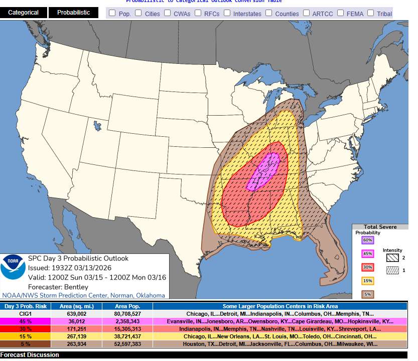
2026 Mid-Atlantic Severe Storm General Discussion
Eskimo Joe replied to Kmlwx's topic in Mid Atlantic
Oh- 183 replies
-
- 1
-

-
- severe
- thunderstorms
- (and 7 more)
-

Spring 2026 Pattern Discussion Thread
KakashiHatake2000 replied to Carvers Gap's topic in Tennessee Valley
Your welcome .- 51 replies
-
- 1
-
-
- severe
- mountain snow
- (and 1 more)
-

Spring 2026 Pattern Discussion Thread
Daniel Boone replied to Carvers Gap's topic in Tennessee Valley
Thanks!! -
I post in The Weather Forums: https://theweatherforums.com/index.php?/forum/3-the-weather-forums/
-

Pittsburgh/Western PA WINTER ‘25/‘26
Burghblizz replied to Burghblizz's topic in Upstate New York/Pennsylvania
Fitting that we had 60 MPH gusts today (although obviously a much different day overall) -
Not a big of cap in the warm sector Sunday but still there,some shortwave troughs into West and MID Tn,if that inversion isnt as strong there could be some kicker that pop up ahead of the line,see what the mesoscale models show the upcoming runs
- Yesterday
-
29.7° -SN Coating so far
-
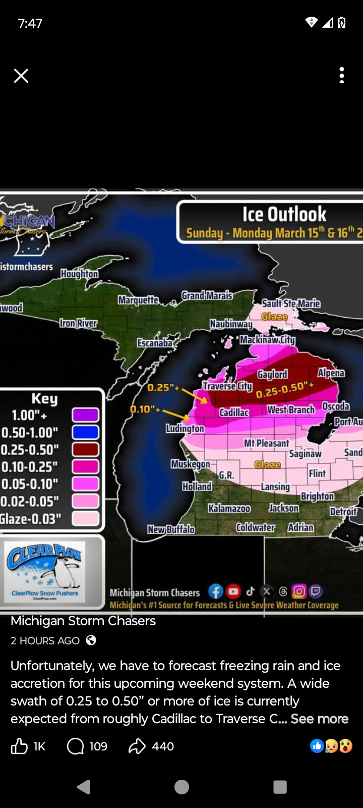
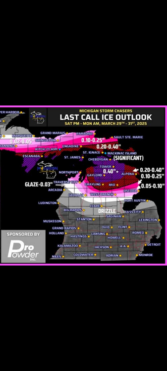
Here's Michigan Storm Chasers ice forecast map for this weekend vs last years storm forecast.

-
I said maybe. Learn how to read snowman19s cousin.
-
There’s no need to call him that. I gave a like to Anthony’s post saying cool start to spring because he was replying to my post showing a trend toward a lower NAO in week 2, in other words starting with calendar spring rather than met. spring. Y’all are talking about different things.
-
For what it's worth....31/19 snow just started. We have about 75% of old snow remaining. We are still in a drought so I will take all the QPF thrown my way over the next few systems
-
Up to 80 mph winds in Ohio. A blizzard to the north and record breaking heat in the west
-
Central PA Spring 2026 Discussion/Obs Thread
Yardstickgozinya replied to Voyager's topic in Upstate New York/Pennsylvania
And just to be clear, anybody could make that mistake with their eyes . That's why surveys are so necessary even with radar confirmation. -
Central PA Spring 2026 Discussion/Obs Thread
Yardstickgozinya replied to Voyager's topic in Upstate New York/Pennsylvania
So while i'm already looking stupid, it's probably a good time to add my stupid analysis. I don't have the means to go back and look at this nor did I ever see it in such high detail but it looks to me like the circulation dog leged and just embedded itself into the cell giving the illusion of a the debris ball. -
I don't always chase tornadoes, but when I do, I zero-meter them
-
Did you like the HRRR this afternoon bringing the SLP up into Minnesota [emoji854]
-
I hate Reddit, they love my weather posts because climate change.
-

80 Degrees to Ripping Snow: March 12th
SnowenOutThere replied to SnowenOutThere's topic in Mid Atlantic
You still have snow on the tops of Shenandoah this afternoon