All Activity
- Past hour
-
https://x.com/i/status/2079366233460281713
-
Absolutely nuts across wake county tonight
-
We literally just got split for like the 10th time the past 5 days. We still got a decent shower but its interesting to watch these microclimate patterns
-
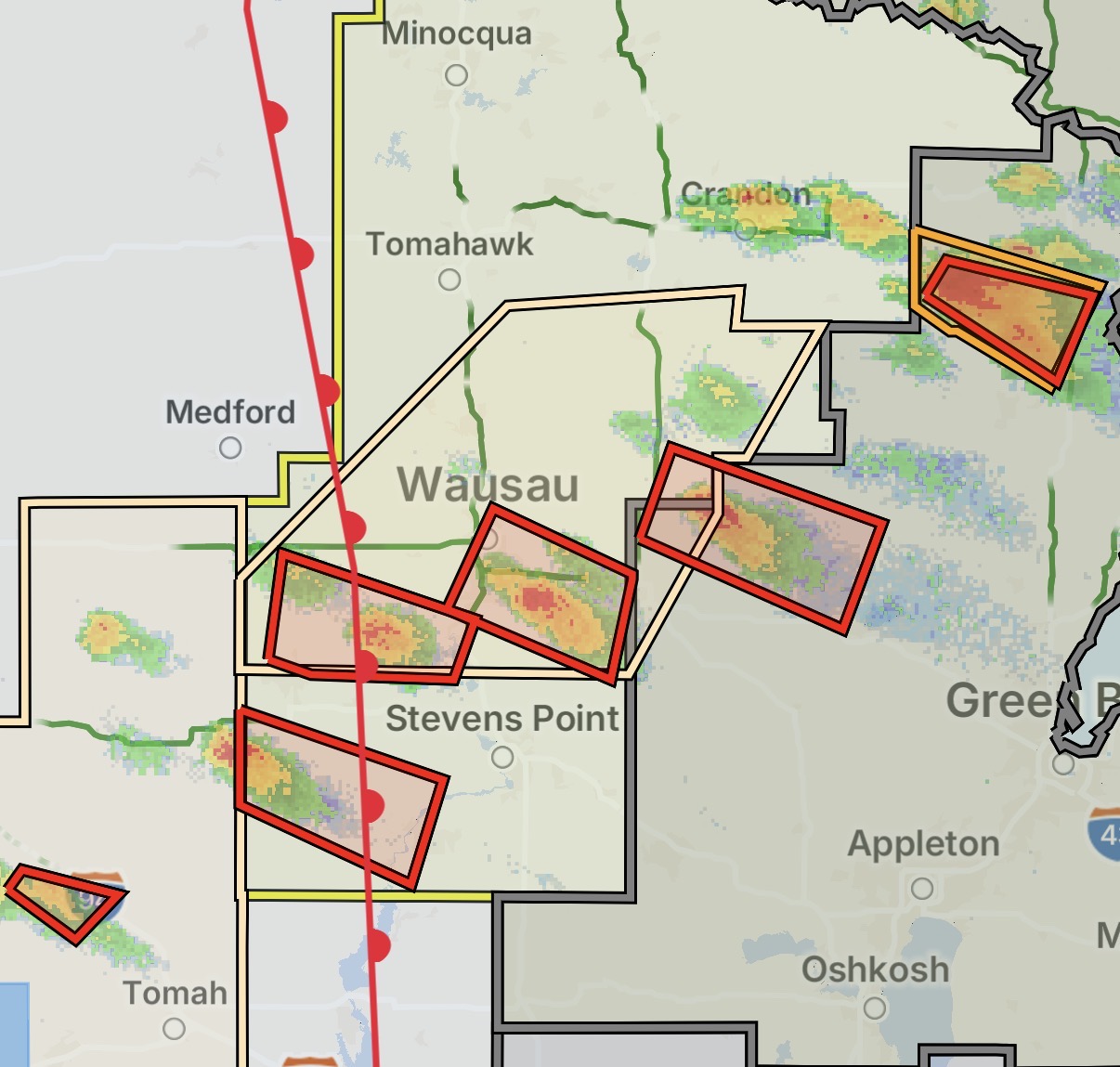
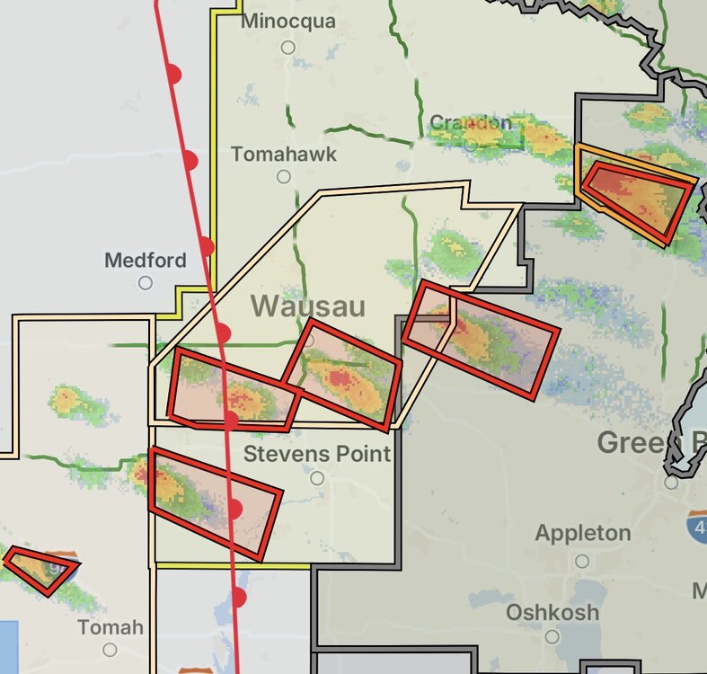
Never seen anything like what's going on in Wisconsin rn
-

2026-2027 Super El Nino
michsnowfreak replied to Stormchaserchuck1's topic in Weather Forecasting and Discussion
Good post. 99% of weather enthusiasts dont care what the temp ranking was in the Conus or the world...they care what happened in their area. The combination of a cold winter in the east and a record warm winter in the west in '25-26 brought some posters to ignore their own weather and concentrate on places elsewhere to a level I've never seen in 24 years on weather forums. -
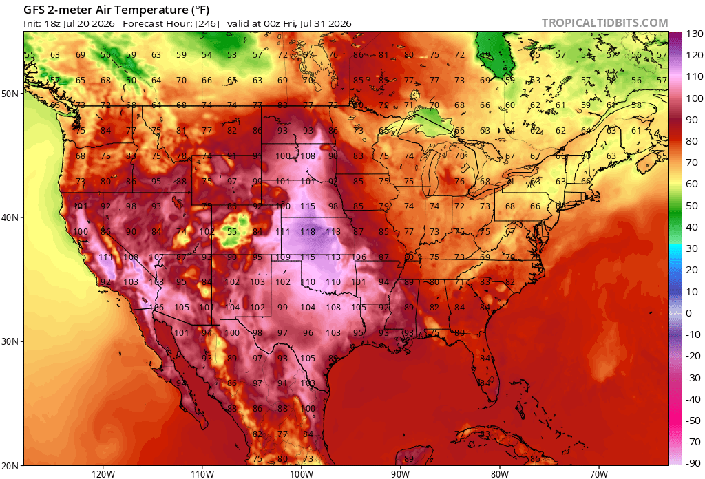
 This is kind of interesting A heat wave in the Plains is obviously not that unusual at this time of year… this thing being repeatedly modeled by the GFS operational run is pernicious tho. I think this is the max day and an unrealistic high approaching 120° near Kansas. It’s also packed back west quite a bit throughout the great basin in California in the Sonoran Desert region. We’ll have to watch that cause the PNA is forecast to take a dip near the 25th… an Iindex state which I have not seen the operational models really take any steps towards acknowledging yet? That could turn out to be one hell of a release event if/when the mass fields were to seesaw into a -PNAP. There could be a little bit of non-linear forcing in here that the operation runs are doing a good job at suppressing perhaps at their own peril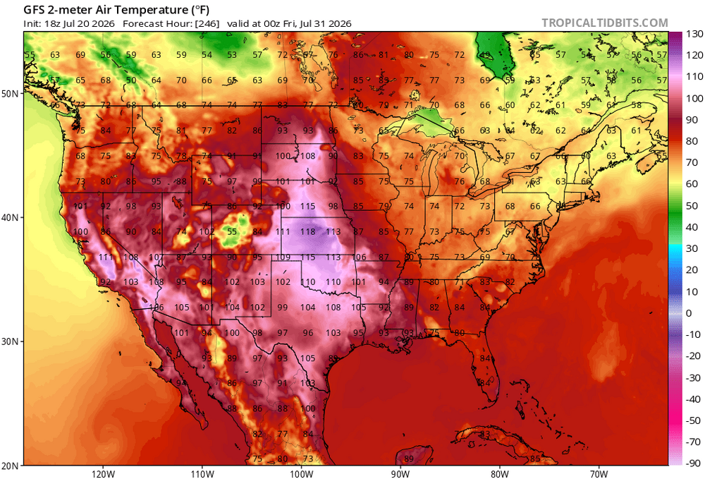
-
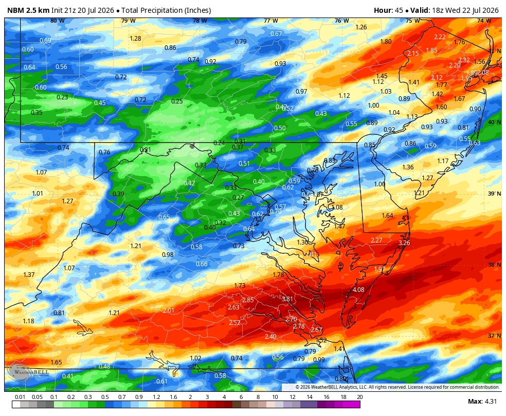
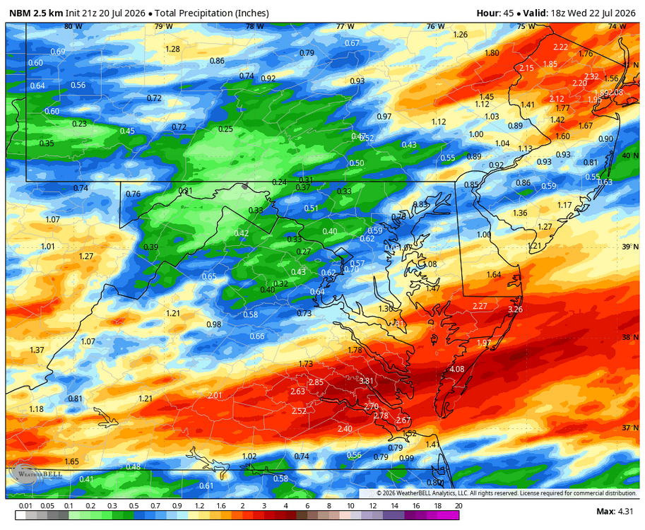
Because most of the models are showing anywhere from a quarter inch to half a foot. high bust potential
-
 How about "GULF OF TRUMP". Once the BUM is voted out an Executive Order will change back to its rightful name. Gulf of Mexico. Tropical entity is weak sauce. My grid data server was DOGED, MFkers Bring back OPENSOURCE grib data!
 -
WB 21Z NBM thru Day 2
-
 CAPE changed their profile photo
 -
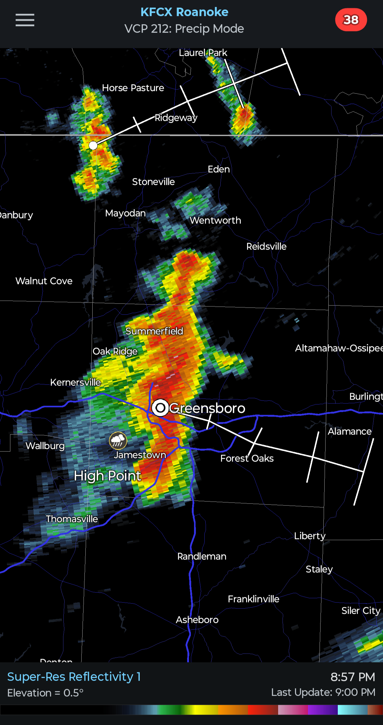
Hitting 1 inch an hour rates right now!
-
Why isn't tomorrow's storm generating more buzz on here? 3-6 inches of rain can be catastrophic.
-
Really great obs, quite frankly in a high storm year we all probably wouldn’t pay much attention to this storm. Bertha isn’t the prettiest, but she may be one of the few options to take home this year. .
-
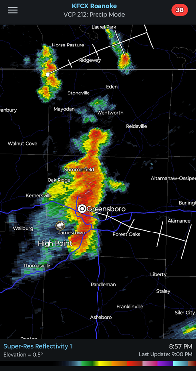
It's a Christmas miracle! Dropping .5"+ across most of Guilford county with frequent lightning. The .53" total at GSO is the most we've had in a day since June 22nd!
-
GENERAC Really no Question. I had one served all my needs. I would wait to pull the trigger as in extended warranty, 2400W on propane...
-
Good grief. Hopefully they get it out of their system before Oshkosh
-

2026 Mid-Atlantic Severe Storm General Discussion
Eskimo Joe replied to Kmlwx's topic in Mid Atlantic
Biggest tornado outbreak in this region. -
I *never* get sick of +CGs, even when they do not strike close. One time, I had one strike about 6 mi from me about 1 hr before sunset, and even though I did not see the bolt, the flash was unusually bright and "encompassing" (meaning it was bright all around me, not a flash in the distance) for the daylight hours, and I go, "ooo, there is going to be big thunder." And I counted, 30 sec later, a really deep THUD! The acoustics can be really bizarre!
- 1,201 replies
-
- 1
-

-
- severe
- thunderstorms
- (and 7 more)
-
 I know some folks can’t seem to get past things…but the Gulf of Mexico is Now officially the Gulf of America. So DIT is completely correct. Nothing political about it…it’s the official name now.
 -
Or the Ivan tor day in Sep 2004? What, like 40 tors in VA alone, and many clustered right up to the MD/VA border just W of DC! I think that day is the only SPC MDT ever issued for a TC tor event. There were so many tors in VA that day, that if you look at a map for the CONUS showing which month tors are most common for each state, VA says "September" -- all b/c of that Ivan tor day! It shows how a single outlier event can skew climo big time.
-
Better humidity than I expected. I’m getting intrigued by the potential of another round of storms. Saturday was fun.
-
Getting some bonus rain and storms this evening. .9 inch so far.
-
 Thought maybe I went a little overboard last night, yet tonight just confirmed my thoughts. Damn Oh well, peace!!
 -
CanSIPS is probably the best possible outcome. Basin wide Nino and h5 looks favorable for cold air delivery via a -EPO/good TPV position, and hints of -NAO at times.
-
I noticed that this year. 45% for wind is being issued more often E of the Mississippi. It can be misleading, esp. when doing stats over time for trends. Our standards are practices change, and the fcst science advances. It reminds me of when MRGL and ENH was added. You get more of a "bulls-eye effect" now when you have a sig svr wx outbreak fcst, but it does not mean things are more amp'ed or intense for sensible wx, just we can just be more precise w/ outlooks given better modelling and knowledge.
-
Huge storm blew up and pummeled east toward 77. Just wet the ground here a little. Story of the summer for the most part.
.thumb.jpg.ad3a2e31d30aff035044689b311a0540.jpg)