
All Activity
- Past hour
-
More storms building. It's not drying out anytime soon.
-
Here we go again https://x.com/TylerSebreezy/status/2085521744992047216 Tyler Sebree @TylerSebreezy The NSSL machine-learning severe probabilities for the next 2 weeks. Certainly adds credence to the severe weather potential over the next 5-6 days across the Midwest, Great Lakes, Ohio Valley, Mid-Atlantic, & Northeast. Storm clusters with wind damage are the most likely risk.
-
Interesting
-

2026 Mid-Atlantic Severe Storm General Discussion
Eskimo Joe replied to Kmlwx's topic in Mid Atlantic
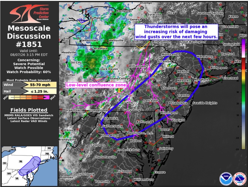
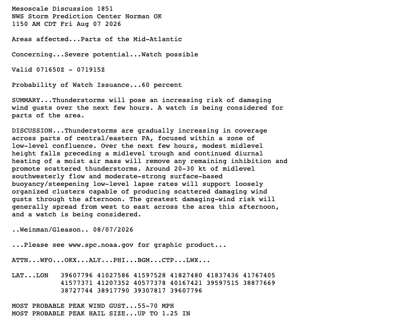
Speaking strictly from parameters on the SPC mesoanalysis page, I'd favor NE Maryland into the western suburbs of Philly today. Weaker lapse rates may be offset by the hillier terrain there as things coalesce. -
-

Augdewst 2026: Summer's Last Stand
Cyclone-68 replied to Prismshine Productions's topic in New England
I remember they followed from Worcester to the Mass Pike into Boston. I miss my western sky view when I could sit there and watch the distant flashes -

Augdewst 2026: Summer's Last Stand
CT Valley Snowman replied to Prismshine Productions's topic in New England
Around 90 here in the CTRV at 1 PM and dewy. Dog days baby. -

Augdewst 2026: Summer's Last Stand
SouthCoastMA replied to Prismshine Productions's topic in New England
88/78.1 -

Augdewst 2026: Summer's Last Stand
weatherwiz replied to Prismshine Productions's topic in New England
ahhh there is nothing like the sound of unsticking your shorts from your body. You have to do it very slowly and in a very quiet environment but its a very pleasant and soothing sound for the ears and your spiritual body. -
-
I do in fact dare
-

Central PA Summer 2026 Discussion/Obs Thread
mahantango#1 replied to Voyager's topic in Upstate New York/Pennsylvania
Severe Thunderstorm Warning PAC067-099-071715- /O.NEW.KCTP.SV.W.0228.260807T1628Z-260807T1715Z/ BULLETIN - IMMEDIATE BROADCAST REQUESTED Severe Thunderstorm Warning National Weather Service State College PA 1228 PM EDT Fri Aug 7 2026 The National Weather Service in State College PA has issued a * Severe Thunderstorm Warning for... North central Juniata County in central Pennsylvania... Central Perry County in south central Pennsylvania... * Until 115 PM EDT. * At 1228 PM EDT, severe thunderstorms were located along a line extending from Mexico to near Spruce Hill to Colonel Denning State Park, moving east northeast at 20 mph. HAZARD...60 mph wind gusts and nickel size hail. SOURCE...Radar indicated. IMPACT...Expect damage to roofs, siding, and trees. * Locations impacted include... New Bloomfield, Mcalisterville, Spruce Hill, Mexico, Loysville, Ickesburg, Walnut, Mifflintown, Port Royal, Thompsontown, Millerstown, and Mifflin. PRECAUTIONARY/PREPAREDNESS ACTIONS... Stay inside a well built structure and keep away from windows. Frequent cloud to ground lightning is occurring with these severe thunderstorms. Move indoors immediately. Lightning is one of nature`s leading killers. Remember, if you can hear thunder, you are close enough to be struck by lightning. Very heavy rainfall is occurring with these severe thunderstorms, and may lead to flash flooding. Do not drive your vehicle through flooded roadways. && LAT...LON 4028 7756 4058 7747 4067 7712 4046 7717 4033 7723 TIME...MOT...LOC 1628Z 257DEG 15KT 4056 7740 4040 7744 4030 7750 HAIL THREAT...RADAR INDICATED MAX HAIL SIZE...0.88 IN WIND THREAT...RADAR INDICATED MAX WIND GUST...60 MPH $$ -
Most of the BN on the NMME is probably being caused by an abundance of rain.But we'll see. In early 98 during a strong Nino the Cumberland had quite a storm caused by dynamical cooling,it was only suppose to be cool light rain,but they ended up with over 20" of wet snow..lol Maybe this winter will have its own analogs as strong as it seems to be ATM.Typically right now the PDO should be more + than - When the strong NINO in 98 started to decline into winter,during April was quite severe,that was the year Southern TN had the F5 tornado.Not saying that will happen agin,just pointing that out
-
Central PA Summer 2026 Discussion/Obs Thread
mahantango#1 replied to Voyager's topic in Upstate New York/Pennsylvania
Thunderstorms and showers are breaking out rapidly. -

Pittsburgh PA Summer 2026 Thread
colonel717 replied to TheClimateChanger's topic in Upstate New York/Pennsylvania
Looks like CPa and west could have snowy Dec -
91/79/106
-
Playing 3 games of softball was the worst idea of all time
-
Meh It was way worse earlier this year Todays feels better than yesterday
-
91/74
-
First of all, how dare you.
-
Someone needs to convince them to just start using the EC-AIFS alongside this. The initialization, bias and skill score improvements are too good not to.
-

Augdewst 2026: Summer's Last Stand
HoarfrostHubb replied to Prismshine Productions's topic in New England
-
Could you imagine if this was 100+ air temps?
-
This, ladies and gents, is what we call a dead cat bounce.
-

Augdewst 2026: Summer's Last Stand
dendrite replied to Prismshine Productions's topic in New England
86.4/68










