All Activity
- Past hour
-
Went to bed with temps in the mid 70’s. Woke to temps in the low 70’s. Missed out on that broken line of showers last night but did get some decent wind against the back of the house.
-
(002).thumb.png.6e3d9d46bca5fe41aab7a74871dd8af8.png)
Central PA Spring 2026 Discussion/Obs Thread
ChescoWx replied to Voyager's topic in Upstate New York/Pennsylvania
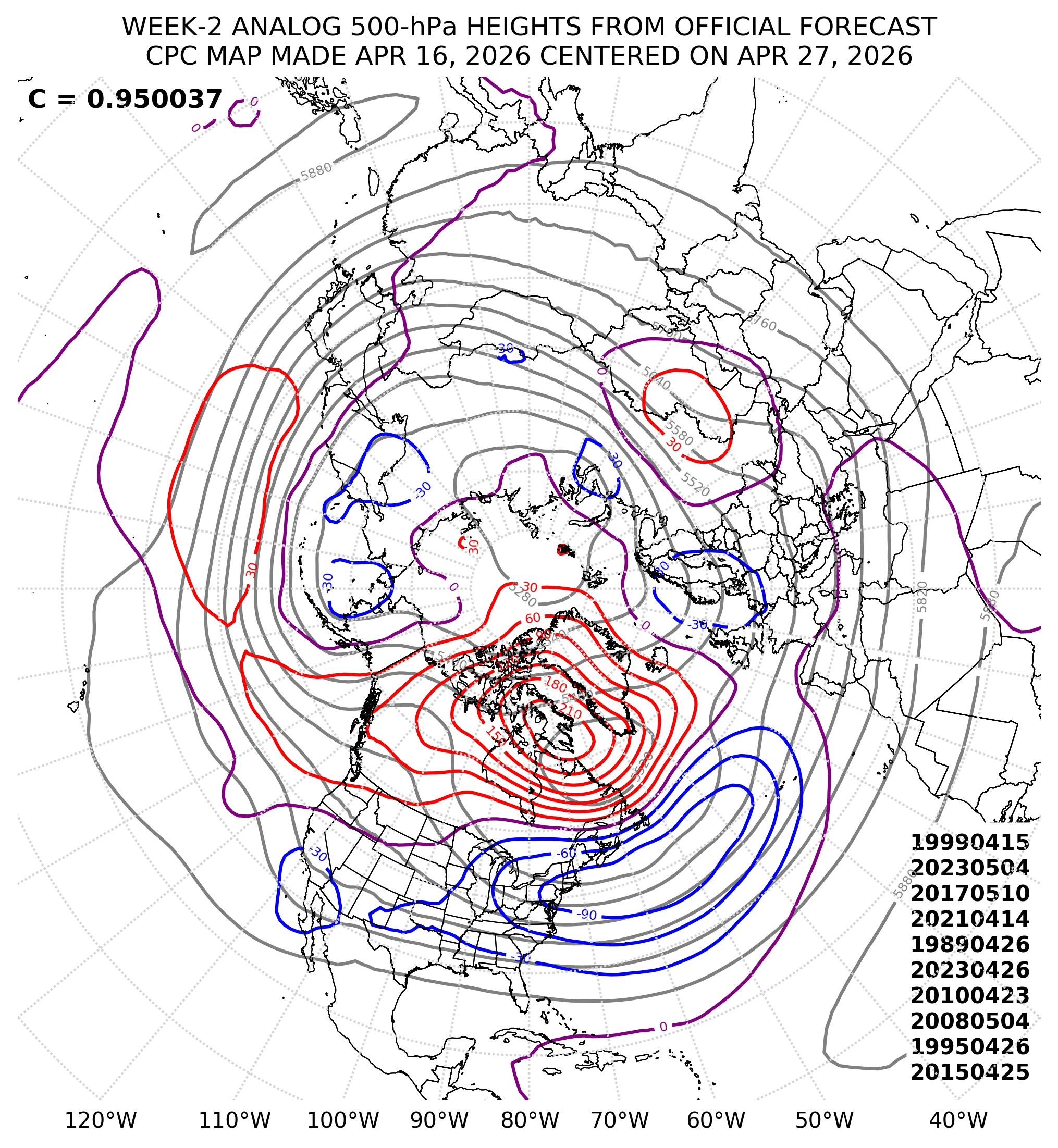
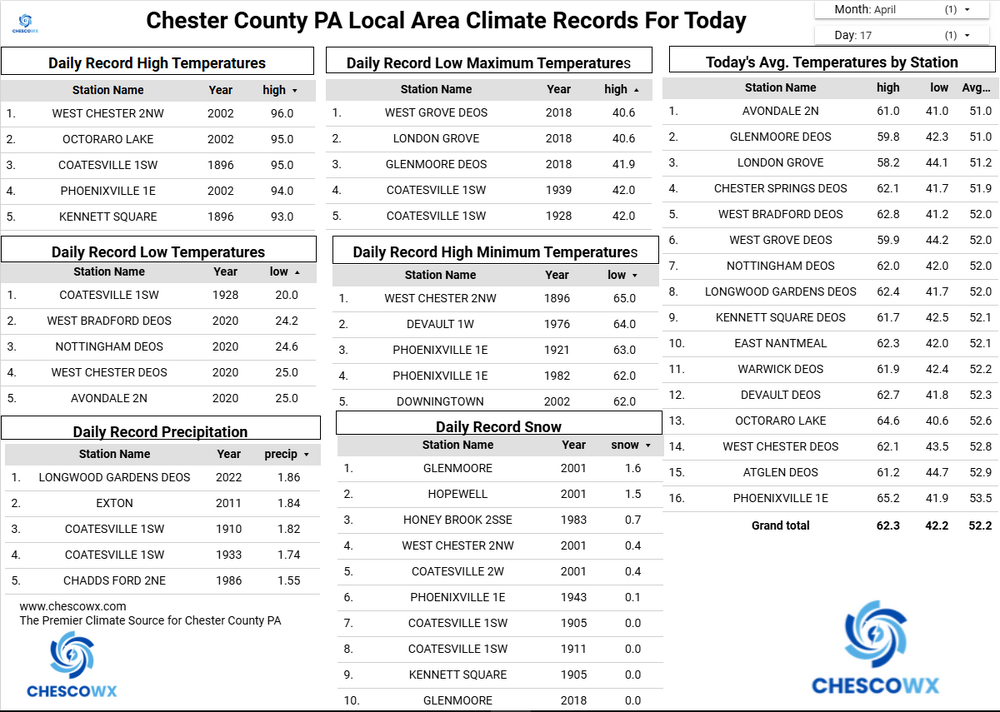
The Devault DEOS station recorded a high of 90.7 yesterday this is the first 90 degree reading at any County station so far this year. None of the other stations reached 90 but upper 80's were common across the valley locations. Today should be 10 to 12 degrees cooler with highs in the mid to upper 70's. This is still 10+ degrees above normal levels. We chill well below normal by Sunday with highs remaining in the low to mid 50's with shower chances increasing. A freeze remains a possibility by Tuesday morning.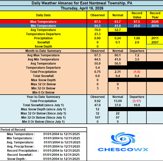
-
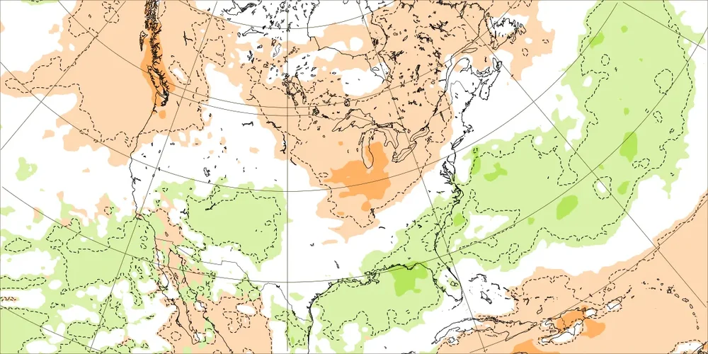
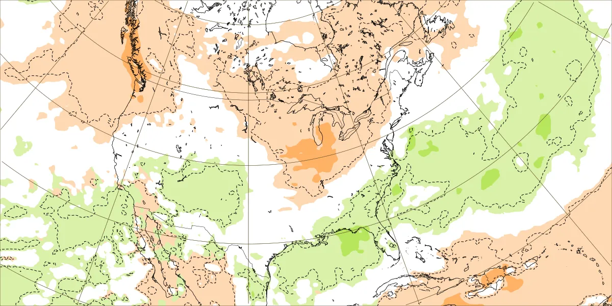
I’m targeting November for the change to consistently wetter than normal in much of the SE, which is typical for strong El Niño autumns. Until then lots of watering is anticipated during dry periods. But good news is that for well before then, the model consensus is showing a pattern change to wetter than normal in ~10 days down and going into early May in my general area, where the drought is the worst in the SE. Fingers crossed that from then through Oct will be closer to normal. Latest Euro Weeklies for Apr 27-May 3:
-
E PA/NJ/DE Spring 2026 Obs/Discussion
ChescoWx replied to PhiEaglesfan712's topic in Philadelphia Region
The Devault DEOS station recorded a high of 90.7 yesterday this is the first 90 degree reading at any County station so far this year. None of the other stations reached 90 but upper 80's were common across the valley locations. Today should be 10 to 12 degrees cooler with highs in the mid to upper 70's. This is still 10+ degrees above normal levels. We chill well below normal by Sunday with highs remaining in the low to mid 50's with shower chances increasing. A freeze remains a possibility by Tuesday morning.
-
-

2026 Spring/Summer Mountain Thread
Maggie Valley Steve replied to Buckethead's topic in Southeastern States
I got enough rain to wash down the pollen! 53 this morning. -
Bone dry here. no significant precip (a couple hundreths here and there) since the 5th/6th. Wind gets above 25 and we've got mini dust storms out here. Pretty crazy. Feels like a desert island. I've got grass that took off thats showing brown because its dry. Hopefully some relief overnight. Timing of these systems lately just suck. By the time they get here we're into overnight hours and lose all forcing. Had one setup (Sweetster hail) where storms trained N and S missing us completely. I could watch both lines from my porch as outflow winds blew through making small dustnado's. My well level is about 4ft below normal. I'm really getting fascinated by micro climates and if theres trends in certain small areas and if there are, what could be the causes. My current problem is not uncommon for this area. We shall see
-
First measurable in 11 days here (a whopping 0.03") fell just before midnight. High was 85.0, not near the record of 90 (and that is the earliest 90 here) from 2002.
-
I'm confused as to why a Severe Thunderstorm Watch wasn't issued for parts of Middle Tennessee last night. We had plenty of warnings west of town last night and trees/power lines down throughout Dickson County (among others). IMHO, a watch should have been set based on ground truth coming out of Kentucky. I know SPC works with the local offices on these things. Certainly, OHX did their job on the warning side. I'm sure pro mets can speak to this better than I could, but either way, I got to think it's not a great look when you have warnings plastered on a RVA grid without the watch backdrop.
-
Yeah. Tomorrow looks pretty nice as well. Even Upton says it short lived. "The cooler regime appears short-lived, with gradual moderation returning conditions to above normal by midweek."
.thumb.png.f41d68de52c5ef27fddfa462b2c37266.png)
.jpg.3be403176790c4e2a355a5fdd4646248.jpg)
-

Central PA Spring 2026 Discussion/Obs Thread
mahantango#1 replied to Voyager's topic in Upstate New York/Pennsylvania
Not looking forward to those temps, I thought with those upcoming temps that would be in your wheelhouse, and maybe you'd post a snow map -
See new posts Your Home Timeline Ryan Hanrahan @ryanhanrahan · 38s Sunday Snow? As colder air rushes in on Sunday, rain may mix with or change to wet snow across the Litchfield Hills. Farther north, a steadier period of snow is expected. Even in Vermont and New Hampshire, significant accumulation is not expected.
-
Ironically, I am right by that .8. Talk about the screw zone! Local mets saying to get out of the drought conditions we would need around 20 to 25 inches of rain the next couple of months. I'd be shocked if we get that much rain in the next year.
-

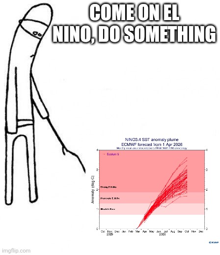
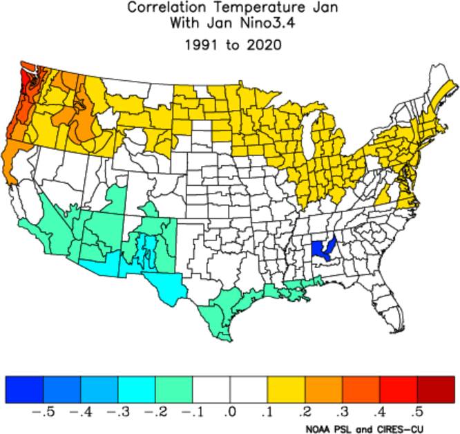
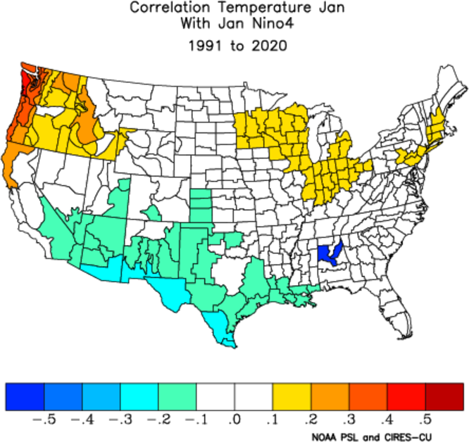
2026-2027 El Nino
LakePaste25 replied to Stormchaserchuck1's topic in Weather Forecasting and Discussion
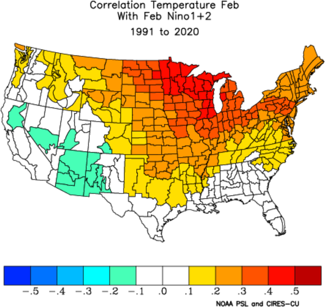
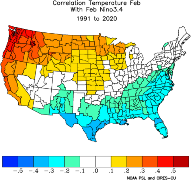
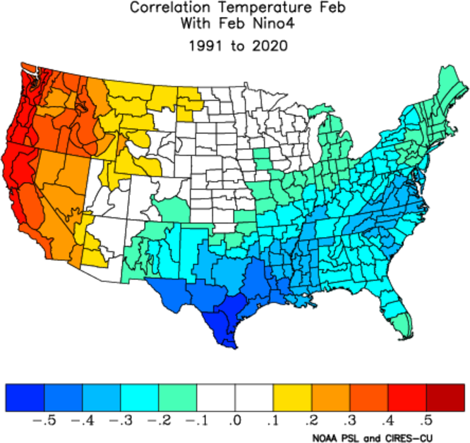
Can really see how things start to diverge in terms of position of the warmest SSTa’s after December. With Nino 1+2 warmth (east-based), Jan and Feb are also warm. With Nino 3.4, the correlation starts to break in Feb. With Nino 4 (central to west pacific), it actually correlated to a cold Feb. So while December is universally expected to be mild regardless, whether we get a backloaded winter or near wall to wall torch is based on whether the anomalies are focused on the Eastern Pacific vs Central.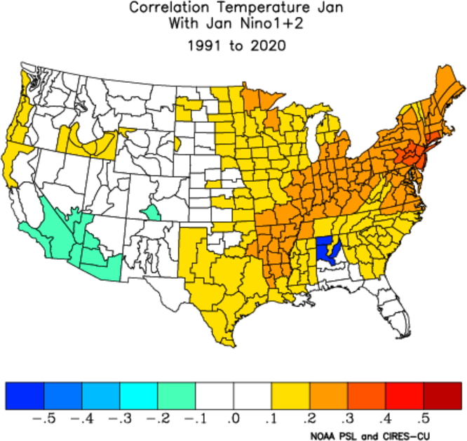
-
would you happen to have a report there for March 13-15, 2023 long duration elevation snowstorm? @snywx as well
-
Wed- Friday look nice . NW flow days with warmish afternoons . Looks fine really after Tuesday morning
-
IPAs?
- Today
-
I never plant up here until Mother’s Day.
-
Rumble just now. That’s a wrap for convective season.
-
We are seeing elements of the spring 2023 pattern with how early and strongly this El Niño is developing. That year had a shift to stronger blocking in late April following early record 90 warmth. Notice the 2 matching dates from 2023 and how close in time the record warmth was. So it’s possible that this week will turn out to be the warmest we see for a while. But rainfall has been generally disappointing. Maybe the developing STJ can allow for some better rainfall opportunities especially by the early summer like we saw in 2023. Newark Area, NJPeriod of record: 1893-05-01 through 2026-04-16DateHighest maximum temperatures (degrees F)Top Record 2nd Record 3rd Record 4/13 92 in 2023 86 in 1977 84 in 2018+ 4/14 93 in 2023 89 in 2026 88 in 2022+ 4/15 91 in 2026 88 in 1960 87 in 1941 4/16 92 in 2002 90 in 2026 89 in 1896
-
Looks like 60’s to near 70 middle/ end of next week
-
s tier lake fog last 12 hours one of my fav times of year
-
If the trough is east of us, probably not much which isn’t good either since many of us are back in a drought.
-
friday evening mood remnants, nothing wrong with that
-
I am curious to see how much rain we actually get vs just low clouds and onshore flow.


.png.c87473893c7c918d039cef4b6cfce1d9.png)