All Activity
- Past hour
-

Spring/Summer 2026 Pattern Discussion Thread
John1122 replied to Carvers Gap's topic in Tennessee Valley
It rained 1.3 inches here with that storm. Trees down. Leaves everywhere like it's fall. -

Spring/Summer 2026 Pattern Discussion Thread
1234snow replied to Carvers Gap's topic in Tennessee Valley
Like a broken record. I should have mowed yesterday while I had the chance. -
1.62" in 30 minutes at the Edgewood Mesonet site. That's a 1/10 year event according to ATLAS14.
-
.34 today... that includes the overnight rain
-
Same old places getting hit. I have a project in Ellicott City that I need to be dry tomorrow. Guess what's headed right towards Ellicott City lol. Of course my yard will stay dry.
-

2026-2027 Record-breaking El Nino
Terpeast replied to Stormchaserchuck1's topic in Weather Forecasting and Discussion
That’s going to be too warm for “all snow” storms along i-95. If we could get that GOA low a bit west, the NA ridge a bit north or east, it’ll make room for a stronger and better placed trough over the SE with a pathway for cold enough air. It’s close to something good, but not quite what we need -

Spring/Summer 2026 Pattern Discussion Thread
Carvers Gap replied to Carvers Gap's topic in Tennessee Valley
Right now, Knox Co is under these… t storm watch t storm warning heat advisory flood advisory flood warning -
Nope, right on time. Wonder if the 20” of rain this summer has done something
-
It's about to nail me, don't worry this will be the story of the winter .
-
GD storm is gonna slide to my north
-
Spring/Summer 2026 Pattern Discussion Thread
Carvers Gap replied to Carvers Gap's topic in Tennessee Valley
Just tagging onto to 1234. More storms. This heat is really fueling these systems. Strong outflow boundaries developing east of the interstate in Cocke and Sevier counties -

2026 Mid-Atlantic Severe Storm General Discussion
SnowenOutThere replied to Kmlwx's topic in Mid Atlantic
Severe storm just past Cvill is rotating anticyclonically -
Late start?
-
Damn, nice pic. I wish i was retired, you lucky bastard.
- Today
-
Charlottesville gets hit with another severe storm. Sure that as soon as I arrive it’ll be the driest remainder of the year on record.
-
Seemed to be parked under a gully washer. Up to .77” now with a rate of 4.37. And there is more behind it. Have my submit a report up for the NWS when this has moved out. For sure will be over an inch.
-
@dailylurker Frederick bullseye!
-

Augdewst 2026: Summer's Last Stand
CoastalWx replied to Prismshine Productions's topic in New England
Sounds about right lol. I honestly don’t know the exact details. Maybe @vortex95 does -
75°+ dews will do that!
-
Current rate is 1.37” up to .24” already. Water is streaming down the windows the gutter cannot keep up.
-

2026-2027 Record-breaking El Nino
EasternLI replied to Stormchaserchuck1's topic in Weather Forecasting and Discussion
CPC MJO update from today confirming the mid month constructive interference that was targeted and verified. Culminating in the current WWB activity. Also the difficulty in identifying the MJO due to the strong Nino. The propagation though the western hemisphere was making me think a recurving typhoon was possible as a consequence of that. But that looks like a failed idea on most recent guidance. So still waiting on that. A selection of the bullet points from the update below: • The strong El Niño continues to be the major influence on anomalous rainfall and tropical cyclone (TC) development throughout the global tropics. • During mid-August, the MJO began to constructively interfere with the strong El Niño similar to what occurred in July. • The MJO is expected to propagate eastward over the Western Hemisphere during late August and then shift back to the Indian Ocean by early September. • The strong El Niño and a favorable MJO are likely to result in multiple TCs developing over the East Pacific through the end of August. However, a robust monsoon response in the Desert Southwest of the U.S. is not expected. • High shear, associated with El Niño, will continue to inhibit TC formation in the Main Development Region of the Atlantic. • A wave-1 pattern persisted in the global upper-level velocity potential fields predominantly tied to the strong El Niño. • Although the strong El Niño is the main influence on the velocity potential anomalies, the MJO recently shifted east across the Pacific which led to the largest anomalous upper-level divergence in the past six months. • As the enhanced phase of MJO constructively interfered with the El Niño base state during early to mid-August, the RMM index exited the unit circle in Phase 6. • This behavior of the RMM based signal is very similar to the path taken earlier this summer. • Positive SST anomalies continue over the central and eastern Pacific, with anomalies now at 1.8°C across NINO 3.4. NINO 4 has gradually cooled during the past several weeks, associated with increased cloudiness over the region. • Remarkably strong positive subsurface temperature anomalies (> 2.5°C) persist across the Eastern Pacific. • Negative subsurface temperature anomalies have expanded eastward to near the Date Line. • A majority of GEFS and ECMWF ensemble members depict the RMM index remaining over phases 6 and 7 due to the strong El Niño. It is difficult to discern the MJO evolution during the next month. -

Augdewst 2026: Summer's Last Stand
Brewbeer replied to Prismshine Productions's topic in New England
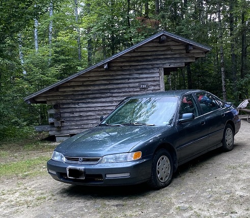
There was no cellular data at the campsite unless it was between midnight and 6:00 am so I didn't get to post during, but did want to post a couple of photos I got from the trip: Hiking up Washington (with my "adult" children) from Lakes of the Clouds: Fox lean-to in Big Deer State Park. Vermont has the best lean-tos, hands down. Glad we had it too, it rained 2 of the 3 nights we were camping, and one of them was a full on thunderstorm with at least an inch of heavy rain: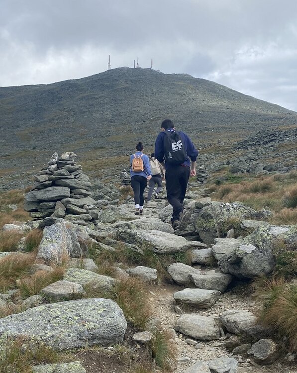
-
I’m not that surprised. It was legitimately humid out again. That is the number 1 difference between this summer and the previous few. Mid 70 dews is gulf coast level.
-

Central PA Summer 2026 Discussion/Obs Thread
canderson replied to Voyager's topic in Upstate New York/Pennsylvania
It’s real oppressive out there with the SE Texas level humidity. Then again it could be a million times worse: this is the forecast back at home this week. This Afternoon Sunny and hot, with a high near 105. South wind around 5 mph. Tonight Clear, with a low around 82. South southeast wind around 5 mph. Tuesday Sunny and hot, with a high near 106. South wind 5 to 10 mph. Tuesday Night Mostly clear, with a low around 82. South wind 5 to 10 mph. Wednesday Sunny and hot, with a high near 104. South southwest wind 5 to 10 mph. Wednesday Night Mostly clear, with a low around 82. South wind around 10 mph. Thursday Sunny and hot, with a high near 104. Southwest wind around 5 mph. Thursday Night Mostly clear, with a low around 82. South southeast wind around 5 mph. Friday Sunny and hot, with a high near 104. South southwest wind around 5 mph becoming northwest in the afternoon. Friday Night Mostly clear, with a low around 81. Saturday Sunny and hot, with a high near 103. Saturday Night Mostly clear, with a low around 81. Sunday Sunny and hot, with a high near 103. -
83/71 currently...0.29" for event.