All Activity
- Past hour
-

Pittsburgh PA Summer 2026 Thread
ChalkHillSnowNut replied to TheClimateChanger's topic in Upstate New York/Pennsylvania
NOT looking forward to the next several days -
(002).thumb.png.6e3d9d46bca5fe41aab7a74871dd8af8.png)
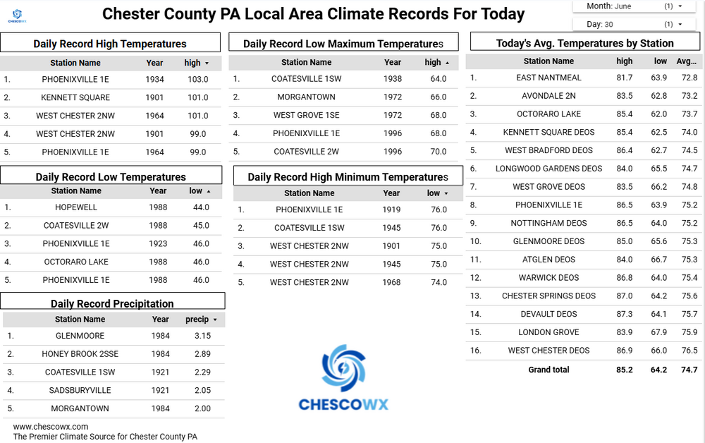
E PA/NJ/DE Summer 2026 Obs/Discussion
ChescoWx replied to PhiEaglesfan712's topic in Philadelphia Region
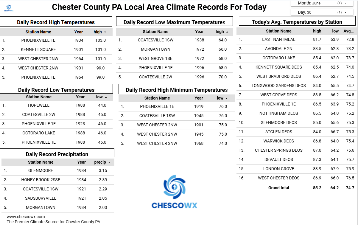
Today should be our last sub 90 degree high until Monday. Mid to upper 80's today rising into the low to mid 90's tomorrow and then upper 90's in higher spots to near 100 in our valley locations both Thursday and Friday. Shower chances increase later July 4th with the days trending slightly cooler with highs by Monday in the upper 80's.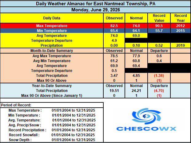
-
Central PA Summer 2026 Discussion/Obs Thread
ChescoWx replied to Voyager's topic in Upstate New York/Pennsylvania
Today should be our last sub 90 degree high until Monday. Mid to upper 80's today rising into the low to mid 90's tomorrow and then upper 90's in higher spots to near 100 in our valley locations both Thursday and Friday. Shower chances increase later July 4th with the days trending slightly cooler with highs by Monday in the upper 80's.
-
Glad the temps haven’t reached 100 yet, highs around 95 and only a couple heat advisories this summer which is pretty surprising.
-

Central PA Summer 2026 Discussion/Obs Thread
Mount Joy Snowman replied to Voyager's topic in Upstate New York/Pennsylvania
MDT daily record highs for July 1 thru July 4 -- 100, 104, 107, and 104. That is one tough set of records to breach. Tomorrow is obviously the most gettable but that's also the one day where my current forecast is under 100. We shall see but quite the historic heat wave on tap regardless. -
woke up to 80, lol
-
Historically will this 3-4 day stretch sit near the top? I think last time 3 days of 100 or greater was July 93?
-

Fireworks Heat Contest W 7/1 - S 7/4 for Five MA Airports
nw baltimore wx replied to nw baltimore wx's topic in Mid Atlantic
Just a reminder that this will stay open for entries and edits until about 11PM tonight. In the spirit of transparency, my entries above are final. -
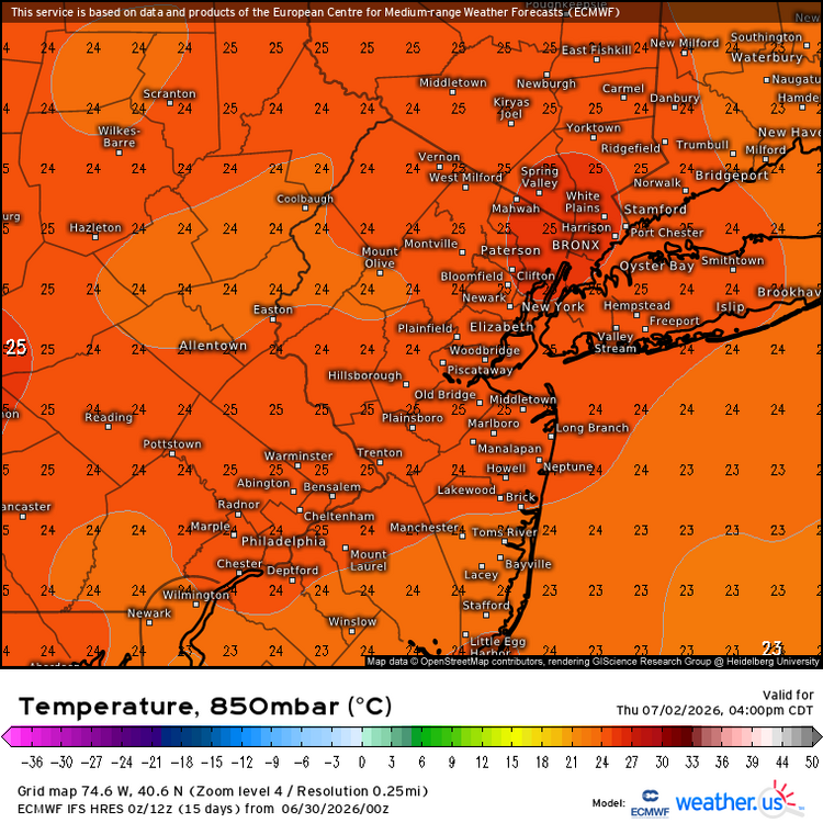
Central PA Summer 2026 Discussion/Obs Thread
ChescoWx replied to Voyager's topic in Upstate New York/Pennsylvania
Of course station location placement and relative elevation -
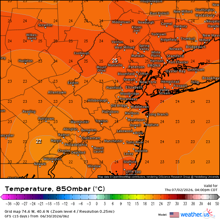
The usual warm spots around the area have a shot at 104°-105° or maybe even warmer. Both the Euro and GFS have 850mb temperatures around +25 C Thursday and Friday. I believe July 2011 was the last time 850 mb temperatures reached this high.

-

2026-2027 Super El Nino
40/70 Benchmark replied to Stormchaserchuck1's topic in Weather Forecasting and Discussion
We've definitely already peaked as far as the Pacific cold phase goes....likely pretty near neutral for the coming winter (slightly negative probably favored), but I still think it will be early next decade, around the solar min, when we truly switch into the new warm phase. Like a very big winter right after the solar min, as we begin the ascending phase. -
 Bring it baby
 -
So frustrating to watch the lack of accountability on a day to day basis. They are making minor league mistakes on simple infield defensive plays and don't forget the baserunning gaffes. THe players are accountable at this level, but the coaching should also be held accountable. Definitely need to make some major changes before they get any better. Makes me wonder why they don't get someone like Joe Madden to come in and clean house.
-
Where we thought pitching wouldn't be much of an issue for the Phillies this year... it is!
-
Topped out at 92 yesterday.
-
In the next few years I will replace my 2018 CX-5. But it probably won’t be for the new one. What they did to that poor car…
-

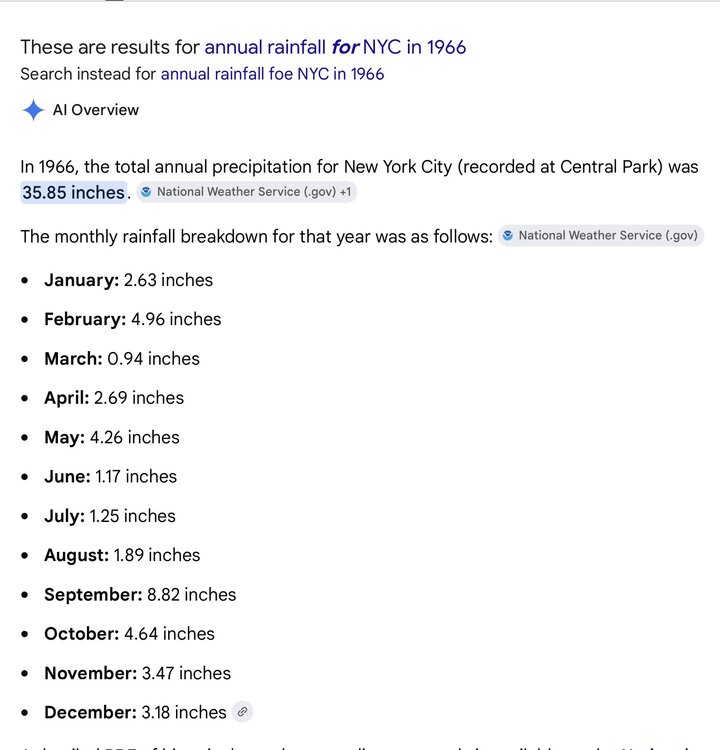
Central PA Summer 2026 Discussion/Obs Thread
mahantango#1 replied to Voyager's topic in Upstate New York/Pennsylvania
-
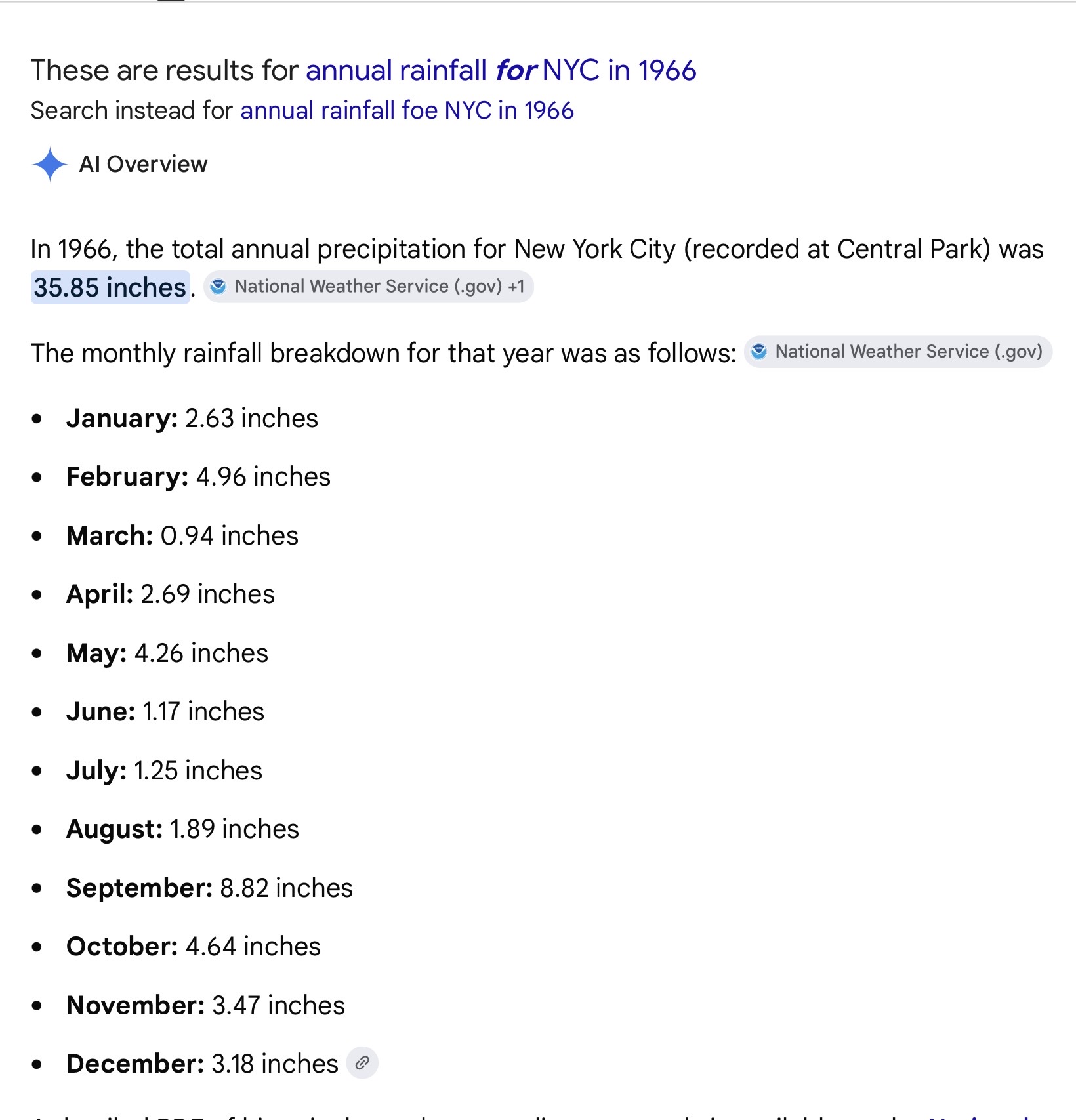
Good morning MANDA, FPizz. I was 19 that year. I remember water restrictions and people having wells dug in their back yards. I simple searched 1966 rainfall. For NYC, the summer was extremely dry. There may have been a tropical system involved in the September total, I just don’t recall. You need no correction, MANDA, about that summer. Stay well and hydrated. As always ….
-
Sometimes, despite the apparent talent, it just doesn't work collectively. Not aways easy to pin down, and in most cases there are multiple reasons. Look at the Mets the past 2 seasons. Absolute disaster. I think its time to make changes. Make some deals at the deadline but more for the future, not necessarily to try to win now. Trade Alonso. Get a couple good younger players, and jettison players like Mayo and Cowser. Busts.
-
The last month that my station had 5+ inches of rain was Aug 2024. The prior 14 months saw 7 of them exceeding the 5" mark. Really impressed with the suddeness of and now the longevity of this drought.
-
Home brew next week?
-
I take their sloppy leftovers of rain/light rain from what’s left of the complex
- Today
-
Storms Wednesday-friday look isolated at best. Maybe scattered Saturday, with far NW favored. Potentially widespread Sunday and Monday.
-
Central PA Summer 2026 Discussion/Obs Thread
Mount Joy Snowman replied to Voyager's topic in Upstate New York/Pennsylvania
Low of 66. Bring on the heat. -
NYC and other locations continuing the drought pattern which emerged back in September 2024. NYC hasn’t had a month with above average precipitation since May 2025. This will enhance the record heat potential around the area going into July. June 2026 MONTH TO DATE 3.39 4.41 -1.02 May 2026 NATIONAL WEATHER SERVICE NEW YORK, NY 635 PM EDT MON JUN 01 2026 ................................... ...THE CENTRAL PARK NY CLIMATE SUMMARY FOR THE MONTH OF MAY 2026... CLIMATE NORMAL PERIOD 1991 TO 2020 CLIMATE RECORD PERIOD 1869 TO 2026 WEATHER OBSERVED NORMAL DEPART LAST YEAR`S VALUE DATE(S) VALUE FROM VALUE DATE(S) NORMAL ................................................................ TEMPERATURE (F) RECORD HIGH 99 05/19/1962 LOW 32 05/06/1891 HIGHEST 93 05/19 MM MM 85 05/03 LOWEST 45 05/03 MM MM 47 05/23 AVG. MAXIMUM 71.5 71.4 0.1 69.5 AVG. MINIMUM 54.9 55.0 -0.1 55.2 MEAN 63.2 63.2 0.0 62.3 DAYS MAX >= 90 2 1.0 1.0 0 DAYS MAX <= 32 0 0.0 0.0 0 DAYS MIN <= 32 0 0.0 0.0 0 DAYS MIN <= 0 0 0.0 0.0 0 PRECIPITATION (INCHES) RECORD MAXIMUM 10.24 1989 MINIMUM 0.30 1903 TOTALS 3.05 3.96 -0.91 6.58