All Activity
- Past hour
-
Great to have it during the lowest sun angle of the year too so we’re not losing much of it every day like in March.
-
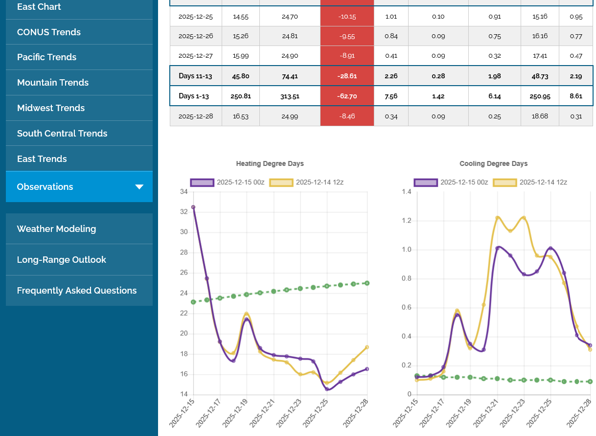
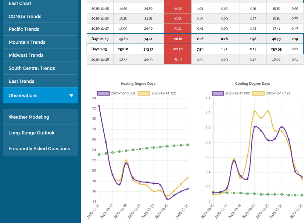
Yeah, unfortunately here’s the ugly truth for E US cold preferrers (NG is down another 1% today making it a whopping 26% drop from the peak 11 days ago): left graph has EPS HDD (latest out/0Z in purple); note the cliff dive it takes from today’s very cold 33 HDD, which is a whopping 10 above the normal of 23, to 12/18’s mild 18, which is 6 below the normal of 24! It later gets as low as 15 on 12/25, which is 10 below the normal of 25!
-
A week before solstice and cloud cover is keeping it cool. We're barely reaching SW/LW equilibrium.
-

December 2025 regional war/obs/disco thread
weatherwiz replied to Torch Tiger's topic in New England
If things unfolded as advertised, I wouldn't be surprised if we had a decent chance of throwing more moisture our way given the southwesterly flow around the stout high across the southeast. However, I think what we would really want to see is a deamplifying wave like you said...or even a strong Arctic cold front plowing southeast across the Plains which would help tap into the Gulf. What would be excellent if there was a connecting the the equatorial PAC...we would be golden I think there -
Heck yea. This cool stretch has been legit impressive.
-

December 2025 regional war/obs/disco thread
TauntonBlizzard2013 replied to Torch Tiger's topic in New England
Yeah, I’m not going to argue anymore, but is 100% the truth. There would be posts talking about how it fits the pattern, etc. I mean, let’s just be honest about what’s really happening. People don’t want to discuss the potential negative outcomes, it’s as simple as that. -
Temperatures seem to be on the low side of guidance. Still only 27 near me at 1pm.
-

Pittsburgh/Western PA WINTER ‘25/‘26
RitualOfTheTrout replied to Burghblizz's topic in Upstate New York/Pennsylvania
Yes, at least one I remember actually happened on Christmas Eve. Wave developed along a front, front went through, temps dropped and rain turned to snow as the developing wave stalled the front. -
Mid-December has been prime time for snow across the region since 2011. Time Series Summary for NEWARK LIBERTY INTL AP, NJ 12-01 to 12-10 snowfall Click column heading to sort ascending, click again to sort descending. 2025-12-10 0.1 0 2024-12-10 T 0 2023-12-10 T 0 2022-12-10 T 0 2021-12-10 T 0 2020-12-10 0.5 0 2019-12-10 2.5 0 2018-12-10 T 0 2017-12-10 4.3 0 2016-12-10 T 0 2015-12-10 0.0 0 2014-12-10 0.1 0 2013-12-10 3.1 0 2012-12-10 0.0 0 2011-12-10 0.0 0 Time Series Summary for ISLIP-LI MACARTHUR AP, NY 12-01 to 12-10 snowfall Click column heading to sort ascending, click again to sort descending. 2025-12-10 T 0 2024-12-10 T 0 2023-12-10 T 0 2022-12-10 0.0 0 2021-12-10 T 0 2020-12-10 T 0 2019-12-10 1.9 0 2018-12-10 T 0 2017-12-10 1.3 0 2016-12-10 0.0 0 2015-12-10 0.0 0 2014-12-10 0.1 0 2013-12-10 1.6 0 2012-12-10 0.0 0 2011-12-10 T 0 Time Series Summary for NEWARK LIBERTY INTL AP, NJ 12-11 to 12-20 snowfall Click column heading to sort ascending, click again to sort descending. 2025-12-20 4.1 6 2024-12-20 0.3 0 2023-12-20 0.0 0 2022-12-20 0.1 0 2021-12-20 0.0 0 2020-12-20 11.4 0 2019-12-20 1.7 0 2018-12-20 T 0 2017-12-20 2.8 0 2016-12-20 3.4 0 2015-12-20 0.0 0 2014-12-20 0.2 0 2013-12-20 6.3 0 2012-12-20 0.0 0 2011-12-20 0.0 0 Time Series Summary for ISLIP-LI MACARTHUR AP, NY 12-11 to 12-20 snowfall Click column heading to sort ascending, click again to sort descending. 2025-12-20 5.8 6 2024-12-20 T 0 2023-12-20 0.0 0 2022-12-20 0.4 0 2021-12-20 0.0 0 2020-12-20 7.5 0 2019-12-20 2.3 0 2018-12-20 T 0 2017-12-20 3.4 0 2016-12-20 3.2 0 2015-12-20 0.0 0 2014-12-20 0.3 0 2013-12-20 4.8 0 2012-12-20 0.0 0 2011-12-20 0.0 0 Time Series Summary for NEWARK LIBERTY INTL AP, NJ 12-21 to 12-31 snowfall Click column heading to sort ascending, click again to sort descending. 2024-12-31 3.2 0 2023-12-31 0.0 0 2022-12-31 T 0 2021-12-31 0.1 0 2020-12-31 0.0 0 2019-12-31 0.0 0 2018-12-31 T 0 2017-12-31 0.6 0 2016-12-31 T 0 2015-12-31 0.3 0 2014-12-31 T 0 2013-12-31 T 0 2012-12-31 1.9 0 2011-12-31 0.0 0 Time Series Summary for ISLIP-LI MACARTHUR AP, NY 12-21 to 12-31 snowfall Click column heading to sort ascending, click again to sort descending. 2024-12-31 2.1 0 2023-12-31 0.0 0 2022-12-31 0.0 0 2021-12-31 0.3 0 2020-12-31 0.0 0 2019-12-31 0.0 0 2018-12-31 T 0 2017-12-31 1.3 0 2016-12-31 0.0 0 2015-12-31 T 0 2014-12-31 0.0 0 2013-12-31 1.7 0 2012-12-31 0.6 0 2011-12-31 0.0 0
-

December 2025 regional war/obs/disco thread
weathafella replied to Torch Tiger's topic in New England
Ok op huggers-today’s euro is snowy for many of us. -
Bamwx's video out today supports that and the return to winter. Coincidentally, the video shows exactly what I posted yesterday to Larry that this Friday's cold front wasn't on modeling several days ago.
-

December 2025 regional war/obs/disco thread
SouthCoastMA replied to Torch Tiger's topic in New England
Its been advertising snow around that time, off and run, for the past several days. Oh wait, I'm breaking the rule of talking about long range OP runs. -
with respect to that surface hp around the 22nd/23rd, there isn't much to suggest we're gonna run a big moisture plume into it right now and even a 6z gfs front ender doesn't have a lot of support at this time (including from 12z). But maybe a deamplifying wave of some kind could be in play on the front side of the ridge going up in the center of the CONUS. Normally that's not gonna excite most people, but could be the difference in a white Christmas for some.
-
-

December 2025 regional war/obs/disco thread
Great Snow 1717 replied to Torch Tiger's topic in New England
100% correct! -
Read this over the weekend... Consistent snow cover through the first 12 days of December has happened only four other times since 1938. Cleveland hasn’t seen bare ground since Thanksgiving, with snow remaining on the ground through every day of December so far — an early-season stretch that has happened only a handful of times in the city’s recorded history. Climate records from Cleveland Hopkins International Airport since 1938 show that Cleveland has had consistent snow cover from Dec. 1 through Dec. 12 in only four other years: 1958, 1974, 1976 and 2002. Snow-on-the-ground measurements come from a single site at Cleveland Hopkins Airport, where trace readings can occur even when substantial snow remains on the ground elsewhere in the region. The four Decembers that began with snow on the ground for all 12 of the month’s opening days did not all unfold the same way. In 1958, snow remained on the ground for nearly the entire month, finishing with 24 days of snow cover. In 1974, 1976 and 2002, snow lingered well into mid-December before warmer stretches briefly erased it, preventing those months from rivaling the most snow-dominant Decembers overall. In other words, an early lock-in doesn’t guarantee a snow-covered Christmas — but it does tilt December toward a more wintry-than-usual outcome. Historically, the most snow-dominant Decembers — measured by days with snow on the ground — include 1963 and 2010, when snow cover lasted 25 days, and 1958, 1989 and 2000, each with 24 days. But for those who feel like winter arrived early this year and never really loosened its grip, the data supports that impression — and shows just how rarely December begins this way.
-

Central PA Winter 25/26 Discussion and Obs
Voyager replied to MAG5035's topic in Upstate New York/Pennsylvania
Good on him. I could use some conditioning myself. I'm quite out of shape. Shovelling yesterday kicked my ass. -

Central PA Winter 25/26 Discussion and Obs
canderson replied to MAG5035's topic in Upstate New York/Pennsylvania
For those unaware, Jon has transformed his body and is in insanely great shape. He is ripped! -
Central PA Winter 25/26 Discussion and Obs
Voyager replied to MAG5035's topic in Upstate New York/Pennsylvania
There you go antagonizing people again... Just kidding. I chuckled when I read this. And I see Sauss thought it was funny, too. -
always got the 12z Euro AI which brings snow in Christmas eve
-

E PA/NJ/DE Winter 2025-26 Obs/Discussion
RedSky replied to LVblizzard's topic in Philadelphia Region
Wonderful day for a power outage -
I’ve been exploring home snow makers so I can never experience a drought again
-
Bam wx update. I'm in!
-
That looks like a lock. Unfortunately if the PNA is still -2 to -3 that won't work, even getting it to 0 is ideal
-

December 2025 regional war/obs/disco thread
WxWatcher007 replied to Torch Tiger's topic in New England
He’s just sitting back…watchin’…waitin’…smilin’…