All Activity
- Past hour
-

February 2026 Medium/ Long Range Discussion: Buckle Up!
snowfan replied to Weather Will's topic in Mid Atlantic
Euro is still aggressive with bringing snow into the area Friday afternoon with the push of arctic air. Many get an 1”+. -
Temperatures have averaged about 10 degrees below normal since Jan 16th. This cold spell is very similar to one in 1961 when the temperatures flipped around mid-Feb to above normal values for 2-3 weeks. Not every Feb with a cold start flips, but others that did flip include 1977 and 1981 which followed quite a cold January and a bland first half of Feb with near-constant record warmth later in Feb 1981. Warmth in later Feb 1977 was less prolific but it kept warming steadily into a very warm March and April (and May apart from one freak arctic blast and snowfalls). Even 1918 which had bitter cold (from Dec 1917) to mid-February began to see some milder spells in a highly variable pattern later in Feb. On the other hand, 1979 and 2015 descended into very deep cold mid-month and beyond. The well-known extreme cold in mid-Feb 1943 was followed by a brief spell near 60F.
- Today
-
I’m surprised there’s no Jan. 1977 too. Also Jan. 1994, Feb. 2015 and Dec. 2017. I wasn’t even aware 1970 had any cold outbreak. Interesting chart! Although this is for <28; maybe <32 would have different results.
-
Sigh, that's what happens during colder than normal winters. Cold and dry, then before a reset of cold weather, a brief warm up and rain.
-

2025-2026 Fall/Winter Mountain Thread
ncjoaquin replied to Buckethead's topic in Southeastern States
I am at .7. The airport is at 13!!! What the heck? Downtown is at 7.2. Edited to add. I have changed these a couple times because downtown and my house have continued to drop, while the airport stays about the same. -
 Good summary and I think this one is definitely a case of details that will not be ironed out until we are on the inside track of the event. The big picture is conducive to a broad snowfall event, but the 700 mb warm layer along the south shore and Cape appears to be the critical swing element, particularly with the warmer NAM/GFS solution versus the colder high-resolution models. A quick punch-out of the initial heavy dose of precipitation could quickly alter totals and this should become apparent through radar imagery and surface observations rather than model output. Snow growth and intensity will also be important, as heavy lift in the dendritic growth zone may help compensate for marginal temperatures for a short period of time. This is definitely a storm situation where real-time impacts, such as snowfall impacts on road access around Boston Logan and Boston Logan car service routes may provide early hints at accumulation efficiency. How much confidence do you have in the colder solutions at this point remaining in place along the south shore once the event is underway?
 -
I can hear CoastalWx from here, "why can't the mean trough position be just 150 mi to the W!!!" But maybe PT action from the NORLUN the 00z ECMWF is explicitly showing, which is pretty amazing it is showing it so far out. Given the 500 low lagging the sfc low so much, this scenario is not unreasonable. And we may have a great line of TSW+ when the strong cold front moves through initially.

-
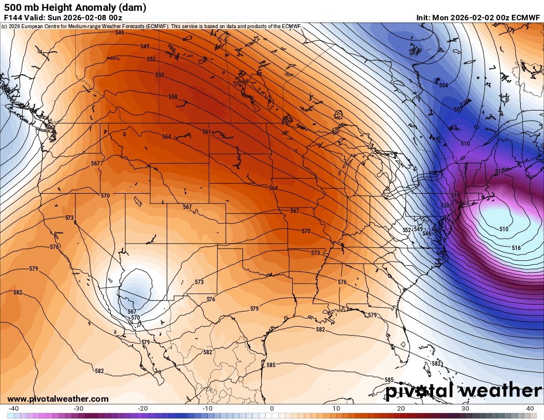
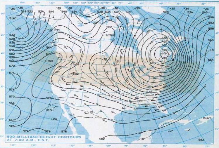
That would be close to record low 500 heights for the NEUS. I attached the 500 from Jan 21, 1985. Just below 480 dm at 500 over CAR, which I think is the record. But no weenie snowstorm for a 6 year old CoastalWx (no 4-8" in the backlash ). Also, there is a KU case from the 1960s where you had 400 m + height falls in 12 hr in the NYC area. 498 dm 500 low right over NYC!
-
The 00z euro beefed up
-
Wxbell (JB) ROTFLMFAOOOO!!!!
-
WxUSAF's weak ass frontal passage thing.
Another Field replied to dailylurker's topic in Mid Atlantic

-
We are either going to tie or break our record low for KTRI by daybreak. Skies are clear, and I am at 0°F at my location. Showing 1°F at KTRI. The official record low for KTRI on February 2nd is exactly 0°F. With a clear sky and no wind, surely we can drop another degree or two at the airport. Edit: And we officially recorded a new record low for February 2nd. Currently -1°F at KTRI.
-
And of the people I met, song writer Paul Williams may be one you guys know.

-
Most of that here falls on 2/13-2/14
-
There is going to be a brief warmup but the month should end up cold.
-
I want this post as a T-Shirt.
-
Said no female ever.
-
Euro shows it too. We rebound very quickly
-

WxUSAF's weak ass frontal passage thing.
stormtracker replied to dailylurker's topic in Mid Atlantic
This alone is banable -
Crazy what a week of prolonged cold can do to some averages. Through yesterday, DCA sits at 35.3F for the winter, good enough for 13th coldest first 2/3rds of winter since 1970 and 2.7F below the 1981-2010 average, the coldest such period since 2010-2011 (34.1F)
-

January 2026 regional war/obs/disco thread
weathafella replied to Baroclinic Zone's topic in New England
39 here tonight. Hopefully it warms up later this week. I did bring my lighter winter jacket. Snow cover all the way from BOS to Georgia on the way down. -
Honestly, I trust the NAM at 84 hours more than the GFS at 60 hours now
-
What about the follow-up wave Wednesday night... Been trending closer and closer for central VA and southern MD
-
-2F now and still falling. Coldest night of winter likely!
-

2025-2026 ENSO
PositiveEPOEnjoyer replied to 40/70 Benchmark's topic in Weather Forecasting and Discussion
Idk about that. Seems to me as though it's shaping up to be a warm Feb nationally. Check tonight's model runs for example and tell me with a straight face we see such a large area of -5 to -7 departures by month's end. Hell the AI models are showing record warmth at times for the Midwest, almost like a hybrid of Feb 2017 and Feb 2024. Not saying it'll be that warm as those were legendary torch months, but I'm just not seeing a cold pattern; things are starting to change in the Pacific. I know these sudden warmer trends are shocking to some, but we also need to stay objective here.