All Activity
- Past hour
-
Had a real nice thunderstorm this morning. Picked up .47" from it. Unfortunately the sun came out afterwards. Currently it is 85/79 for a feels like of 98. No dry air here.
-

Central PA Summer 2026 Discussion/Obs Thread
canderson replied to Voyager's topic in Upstate New York/Pennsylvania
That’s incredible. A foot or so more than me. Really nice weather for August. Cut the grass and did a bit of garden cleanup over lunch and didn’t even break a sweat. Meanwhile Texas is baking. -

Augdewst 2026: Summer's Last Stand
dendrite replied to Prismshine Productions's topic in New England
Def trending warmer, but I’m always wary of these 2m anomalies valid 6z and 18z. And I’m not sure how they calculate those 5 day means…like is it the average of the 6z maps in this case or is it inclusive of all 00,6,12, and 18z images? Because the 6z anomalies are much higher in magnitude than 18z which would signify much warmer mins and not quite as warm days. But 2m aside, 850s have been trending warmer too. -
51 here this morning. Pre-season football and cool morning temps. Feels like Fall is getting closer.
-
 good online mexican pharmacy: MexiSafe Pharm - pharmacy online
 -
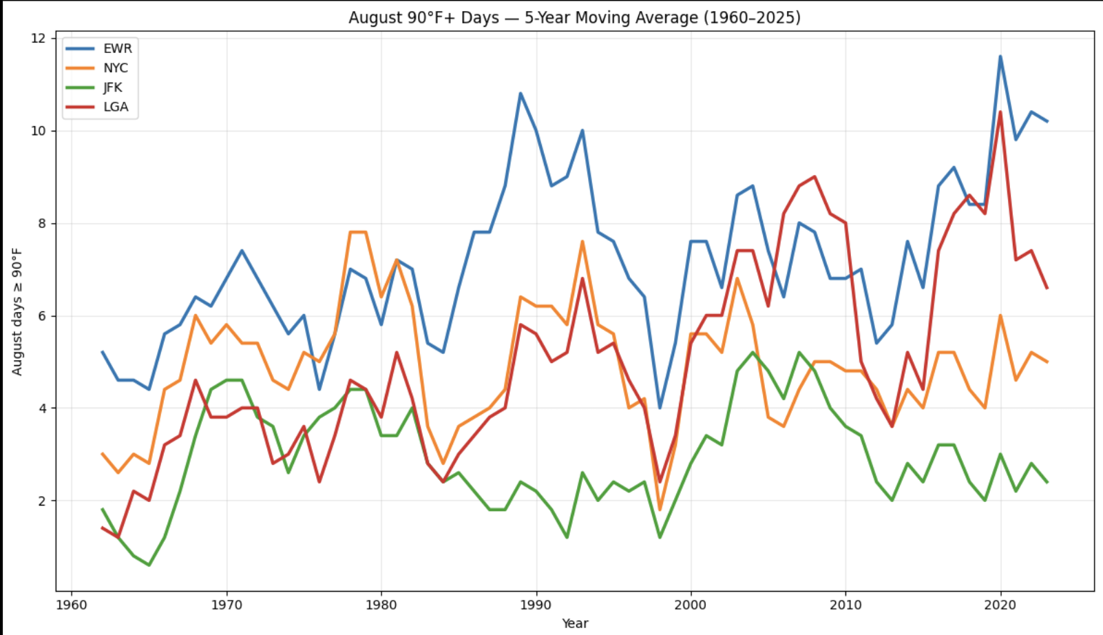
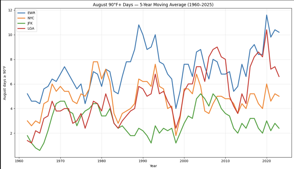
August 90 degree days - it really depends on the year and not easy to make a blankt generalized call 2022 was plenty hot in august: 90 Degree days Augist Year EWR NYC JFK LGA 2025 8 3 0 6 2024 7 6 3 6 2023 5 0 0 0 2022 18 11 5 13 2021 13 5 4 8 2020 9 4 2 10 2019 4 3 0 5 2018 14 7 4 16 2017 2 1 0 2 2016 13 7 6 10 2015 13 8 6 8 2014 2 3 0 1 2013 3 1 0 1 2012 7 3 2 6 2011 4 3 2 2 2010 11 12 8 11 2009 10 5 5 7 2008 2 1 1 0 2007 7 4 4 7 2006 9 3 6 6 2005 12 9 10 10 2004 2 1 0 2 2003 7 2 4 6 2002 14 14 6 13 2001 8 8 4 6 2000 2 1 2 3 1999 7 3 1 2 1998 7 2 1 3 1997 3 2 2 3 1996 1 1 0 1 1995 14 13 8 11 1994 9 2 0 5 1993 11 10 2 7 1992 4 3 0 2 1991 12 10 3 9 1990 9 4 1 3 1989 8 4 3 4 1988 17 10 4 10 1987 8 4 1 3 1986 2 0 0 0 1985 4 2 1 2 1984 8 3 5 2 1983 11 9 6 8 1982 1 0 0 0 1981 3 4 2 2 1980 12 15 7 9 1979 9 8 2 7 1978 4 5 6 1 1977 6 7 5 3 1976 4 4 2 3 1975 5 4 5 3 1974 3 5 1 2 1973 12 6 4 7 1972 4 3 1 0 1971 7 5 7 2 1970 8 8 6 9 1969 6 5 5 2 1968 9 8 4 6 1967 1 1 0 0 1966 8 8 2 6 1965 5 1 0 3 1964 5 4 0 1 1963 3 0 1 0 1962 2 2 1 1 1961 8 6 4 1 1960 8 3 3 4 NYC (Central Park) looks fairly flat overall. But we know the vegetation plays a roll there amongst max JFK is also pretty flat to only slightly variable. EWR shows a modest upward drift. LGA shows the clearest upward drift of the four. Statistic EWR NYC JFK LGA Mean / Average 7.18 4.83 2.88 4.94 Median 7 4 2 3.5 Mode 8 3 0 2 Mode occurred 9 yrs 11 yrs 15 yrs 11 yrs Minimum 1 0 0 0 Maximum 18 15 10 16 Range 17 15 10 16 Standard deviation 4.13 3.59 2.51 4.00 25th percentile 4 2 1 2 75th percentile 9 7 5 7 Total 90° days 474 319 190 326
-

Augdewst 2026: Summer's Last Stand
Snowedin replied to Prismshine Productions's topic in New England
Can’t wait for 5-6 months of cool rains and wind-driven mists while powderdude posts pics of his buried snowmobile in mid March. Anyways, at least today is a beauty..gotta live for the present! -
http://mexisafepharm.com/# mexico pet pharmacy
-
^For the same TW now emerging from Africa:12Z UKMET vs 0Z: similar rapid WNW track through MDR though 2-3 mb stronger starting near 50W. As it leaves MDR and slows down, it strengthens notably to mid-level TS at the end of the run while still moving WNW on heading in direction of SE Bahamas though still 300+ miles from there. Remains a significant SW outlier, which could be due to a SW bias that it sometimes exhibits with weak systems:NEW TROPICAL CYCLONE FORECAST TO DEVELOP AFTER 54 HOURSFORECAST POSITION AT T+ 54 : 11.6N 31.9WLEAD CENTRAL MAXIMUM WINDVERIFYING TIME TIME POSITION PRESSURE (MB) SPEED (KNOTS)-------------- ---- -------- ------------- -------------0000UTC 27.08.2026 60 12.1N 33.5W 1007 301200UTC 27.08.2026 72 12.3N 37.6W 1007 340000UTC 28.08.2026 84 13.2N 41.6W 1008 341200UTC 28.08.2026 96 14.0N 46.3W 1009 350000UTC 29.08.2026 108 14.9N 50.9W 1009 331200UTC 29.08.2026 120 16.5N 55.4W 1010 340000UTC 30.08.2026 132 17.5N 59.1W 1009 331200UTC 30.08.2026 144 18.9N 62.5W 1009 350000UTC 31.08.2026 156 19.6N 65.2W 1008 341200UTC 31.08.2026 168 20.2N 67.8W 1004 52
-
Works for me. done with it by August-the last couple Augusts have featured some very pleasant weather.
-
https://mexisafepharm.com/# pharmacy mexico online
-
Agreed. Less hostile look midway across but once to 55W conditions deteriorate. Something is going to have to find a "sweet spot" somewhere to be a bigger player. Caribbean still shut down. If something can make it to the SW Atlantic and time a trough correctly or get pushed westward under a ridge then maybe something interesting for U.S.
-
Public Information StatementNational Weather Service Mount Holly NJ453 PM EDT Sun Aug 23 2026...NWS Damage Survey for August 20th, 2026 Tornado Event - Update #3....Update...One additional tornado has been confirmed with this update near Hazlettville in Kent County, DE. A total of six tornadoes have now been confirmed within our area from Thursday's severe thunderstorms.The details for the Marydel and Hazlettville tornadoes are includedbelow. There have been no changes to the other tornadoes that were previously confirmed..Dover, DE Tornado...Rating: EF-1Estimated Peak Wind: 100-110 mphPath Length /statute/: 3.2 milesPath Width /maximum/: 100 yards Fatalities: 0Injuries: 0Start Date: August 20, 2026Start Time: 6:09 PM EDTStart Location: 2 miles SW Dover, Kent County, DEStart Lat/Lon: 39.1396 / -75.5564End Date: August 20, 2026End Time: 6:14 PM EDTEnd Location: 1 mile NNE Dover, Kent County, DEEnd Lat/Lon: 39.1700 / -75.5184Summary: On August 20, 2026, a tornado formed over the open fields west of Wyoming Mill Rd near Riverside Rd, scarring the crops before moving to the tree line east of Wyoming Mill Rd, snapping several branches and tree tops. The tornado then made direct contact with the Dover Little League baseball fields at Schutte Park, causing extensive damage across two of their baseball diamonds. At least seven large wooden field lighting fixtures were snapped at either the base or halfway up, falling onto the fencing surrounding the fields. Additional fencing was also ripped from their posts and believed to have been caused directly from the tornadic winds rather than impacted from anotherobject. One large scoreboard secured by a brick foundation fell over and a second one supported by metal posts was bent and likelycrushed by an unknown projectile. Part of a tree was observed in the middle of one of the fields with no clear origin.The tornado then hit the City of Dover VanSant Generating Station, shifting one trailer off its foundation and causing minorroof damage to a metal building structure in addition to visibly denting the metal siding with unknown projectiles. The tornado then carved a path through another tree line before impacting a factory warehouse where some of the most significant damage occurred. Two sections of concrete block walls collapsed, a few trailers were sent tumbling, and a small section of the metal roofcame off. The damage to this facility confirmed max wind gusts ofa high-end EF-1.The tornado then moved ENE. Continuing its path, the tornado zig-zagged through the main downtown area of Dover where it was weaker at this point, downing a few trees and snapping branches along W North Street before turning towards Dover City Hall and turning again towards Memorial Park. The tornado then began movingNNE along Park Dr and Kings Hwy, downing large trees and branches. As it approached the intersection of Kings Hwy and N Dupont Hwy, the tornado intensified again and reached its maximum width of 100 yards. The tornado reached a second peak intensity here as it peeled half of the roof off one motel, damaging the roof to the motel next door, and downing two large business signs.This significant roof damage provided secondary confirmation of max wind gusts of a high-end EF-1. The tornado quickly dissipated afterwards.The National Weather Service would like to thank the Kent County Department of Public Safety and Delaware Emergency Management Agency for their assistance with this survey..Barclay, MD Tornado...Rating: EF-1Estimated Peak Wind: 95-105 mphPath Length /statute/: 0.5 milesPath Width /maximum/: 65 yards Fatalities: 0Injuries: 0Start Date: August 20, 2026Start Time: 5:41 PM EDTStart Location: 2 miles W Barclay, Queen Anne's County, MDStart Lat/Lon: 39.1479 / -75.9016End Date: August 20, 2026End Time: 5:42 PM EDTEnd Location: 1 mile WNW Barclay, Queen Anne's County, MDEnd Lat/Lon: 39.1490 / -75.8910Summary: A brief tornado touched town near Barclay, snapping and uprooting several softwood and hardwood trees in a wooded area next to a residence located near the intersection of Dell Foxx Rdand Barclay Rd. The tornado then moved east across a bean field and onto a residential property on Benton Corner Rd, where more softwood and hardwood trees, including a robust cedar tree, were snapped at the trunk.The National Weather Service would like to thank the Queen Anne'sCounty Department of Emergency Services for their assistance withthis survey..Marydel, DE Tornado...Rating: EF-1Estimated Peak Wind: 90-100 mphPath Length /statute/: 1.33 milesPath Width /maximum/: 60 yards Fatalities: 0Injuries: 0Start Date: August 20, 2026Start Time: 5:54 PM EDTStart Location: 1 mile S Marydel, Kent County, DEStart Lat/Lon: 39.0957 / -75.7399End Date: August 20, 2026End Time: 5:56 PM EDTEnd Location: 2 miles SE Marydel, Kent County, DEEnd Lat/Lon: 39.1025 / -75.7170Summary: A tornado occurred near Marydel beginning along the east side of Grygo Rd, about a quarter mile south of the intersection of Mahan Corner Rd, taking down several tree limbs near a residence. It then crossed Grygo Rd and uprooted two very large oak trees that fell on the corner of a home. Additional hardwood trees were uprooted along the property as the tornado headed ENE into a heavily wooded area. Drone footage showed the tornado continued to cut a path through the treeline, snapping large branches and uprooting a variety of trees down a narrow path. While drone footage was unable to confirm the full length of destruction in the wooded area, just on the other side of the wooded area, a residence along Parkers Chapel Rd experienced the total loss of an old barn and shed in addition to several downed trees and branches.The National Weather Service would like to thank the Kent County Department of Public Safety and Delaware Emergency Management Agency for their assistance with this survey..Hazlettville, DE Tornado...Rating: EF-0Estimated Peak Wind: 70-80 mphPath Length /statute/: 0.6 milesPath Width /maximum/: 100 yardsFatalities: 0Injuries: 0Start Date: August 20, 2026Start Time: 6:02 PM EDTStart Location: 0.3 miles ESE Hazlettville, Kent County, DEStart Lat/Lon: 39.1159 / -75.6368End Date: August 20, 2026End Time: 6:03 PM EDTEnd Location: 0.9 miles ENE Hazlettville, Kent County, DEEnd Lat/Lon: 39.1189 / -75.6271
- Today
-

Augdewst 2026: Summer's Last Stand
WxWatcher007 replied to Prismshine Productions's topic in New England
Looking forward to your posts in the NNE winter thread because if you say this in January the SNE weenies may march on your town with cannon and torches. -

Augdewst 2026: Summer's Last Stand
tamarack replied to Prismshine Productions's topic in New England
Jan 2023 was 9° AN here, our mildest of 28 Januarys, and it had 29.9" snow (avg 20.2") and 101.2" total (avg 88.4"). Different ENSO (mod Nina) but the next winter was mod Nino, our mildest met winter (22-23 was 2nd mildest), and had 99". Sometimes it's nice to be north. -
when you put this summer into strong nino context it was a torch
-

Augdewst 2026: Summer's Last Stand
Great Snow 1717 replied to Prismshine Productions's topic in New England
...and it is why my chips have been pushed into the center of the table lol -

Augdewst 2026: Summer's Last Stand
40/70 Benchmark replied to Prismshine Productions's topic in New England
Always are....we could get 100", and someone like me would flip because Tolland or Weymouth got 103". -
Augdewst 2026: Summer's Last Stand
Great Snow 1717 replied to Prismshine Productions's topic in New England
Time will tell but my chips are on there being some epic meltdowns... -
Augdewst 2026: Summer's Last Stand
40/70 Benchmark replied to Prismshine Productions's topic in New England
I don't think we particularly prone because baseline assumptions aren't high...everyone excepts at least one month of like +8.... -
59 for my low kemp mill
-
It was an early summer again this year. We had that incredible heat wave to start July, but not bad after that. The 2nd half of July was below normal temps, and August is gonna end up about normal. Last summer our hottest weather was in late June. The big heat has been coming very early in recent years.
-
Oh I have lots of deer around here. They're in my back yard very often, so I have fencing around the vegetable garden. Can't have a garden around here without the fencing. I don't put the lettuce in the garden though because the woodchucks are wild about lettuce and would dig under the fence to get in. The lettuce is in pots high up on top of two tables that I have stacked up. I'll start picking the lettuce during the first week of september. I always grow the lettuce for the spring, but it's nice to have it again for september and october.
-
2026 Atlantic Hurricane Season
WxWatcher007 replied to Stormchaserchuck1's topic in Tropical Headquarters
unusable