All Activity
- Past hour
-
Never thought I'd see the day when San Diego would be muggier than DC! They've been getting 70-degree dewpoints lately.
-
 .44 with dryslot moving in. At least got something
 -
 The rain is just getting going here. Meanwhile, dudes out on the western frontier have already seen nearly three months worth of rain in less than a day. When do we get in on the fun?
 -
More sun now and up to 75 here 75 / 69
-
2026 Mid-Atlantic Severe Storm General Discussion
Roger Ramjet replied to Kmlwx's topic in Mid Atlantic
Mine was out for 11 hours. Came back at 3:30 am. Dominion is usually pretty good. -
14+ in 2023. All tstorms . We don’t get those anymore here
-
This explains what went through this part of Raleigh last night: https://www.facebook.com/share/p/1cTLe5BtS1/?mibextid=wwXIfr
-
I had 3.28" in the plastic and 3.56" in the tipper. Take your pick. Seems to match the Cocorahs map pretty well. Either way, it was a utter deluge here around 6:30 last evening and again around 10:30.
-
July 29 1917: The hottest temperature ever recorded in Minnesota, 114.5 degrees, occurs at Beardsley. 1849: Severe storms hit the newly constructed post of Ft. Ripley between 3 and 5 AM. W.J. Frazier, Head Surgeon notes: 'Rain and hail with much thunder and lightning and very high winds breaking many trees.' For Wednesday, July 29, 2026 1898 - The temperature at Prineville, OR, soared to 119 degrees to establish a state record, which was tied on the 10th of August at Pendleton. (The Weather Channel) 1905 - Heavy rain in southwestern Connecticut caused a dam break, and the resulting flood caused a quarter of a million dollars damage at Bridgeport. As much as eleven inches of rain fell prior to the flood. (David Ludlum) 1981 - Fifty cattle, each weighing 800 pounds, were killed by lightning near Vance, AL. The lightning struck a tree and then spread along the ground killing the cattle. (The Weather Channel) 1987 - Thunderstorms produced severe weather from Minnesota to Indiana and Illinois. A thunderstorm at Janesville, WI, produced wind gusts to 104 mph which flipped over two airplanes, and blew another plane 300 feet down the runway. The northeastern U.S. experienced some relief from the heat. Nine cities reported record low temperatures for the date, including Saint Johnsbury, VT, with a reading of 42 degrees. Barnet, VT, reported a morning low of 33 degrees, with frost reported on vegetation. (Storm Data) (The National Weather Summary) 1988 - Afternoon and evening thunderstorms produced severe weather in Minnesota and Wisconsin. Hail three inches in diameter was reported south of Saint Cloud, MN. Hot weather prevailed in the western U.S. Fresno, CA reported a record thirteen straight days of 100 degree heat. (Storm Data) (The National Weather Summary) 1989 - Morning thunderstorms in the Upper Midwest produced more than five inches of rain west of Virgil, SD. Afternoon and evening thunderstorms deluged the foothills and adjacent plains of Colorado with heavy rain. Rains of six to seven and a half inches fell in eight hours north of Greeley. Hail and heavy rain caused several million dollars damage in Weld County. (Storm Data) (The National Weather Summary) Observances: 29 Wed National Chicken Wing Day 29 Wed National Rain Day 29 Wed National Lasagna Day 29 Wed NASA is Founded 29 Wed International Tiger Day 29 Wed National Lipstick Day 29 Wed Cheese Sacrifice Purchase Day 29 Wed National Challenged Champions and Heroes Awareness Day 29 Wed National Get Gnarly Day 29 Wed National Wing Day
-
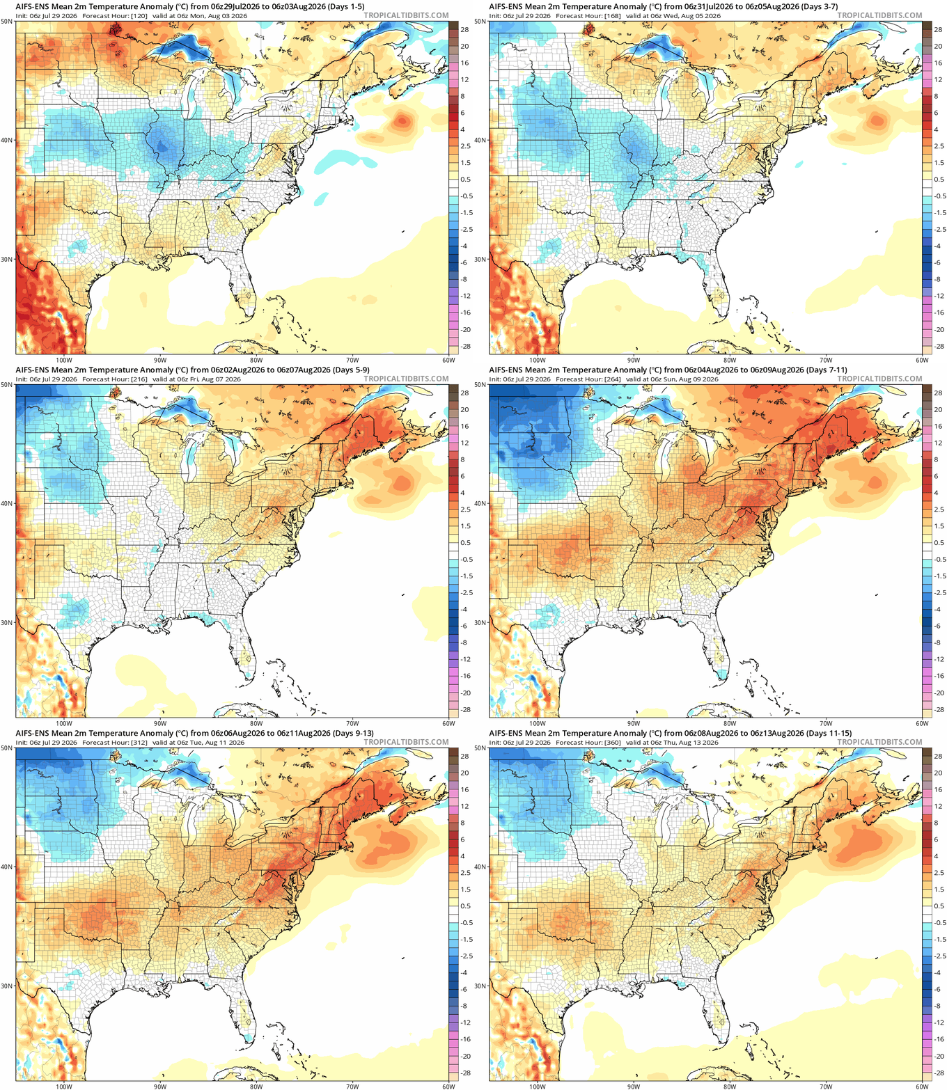
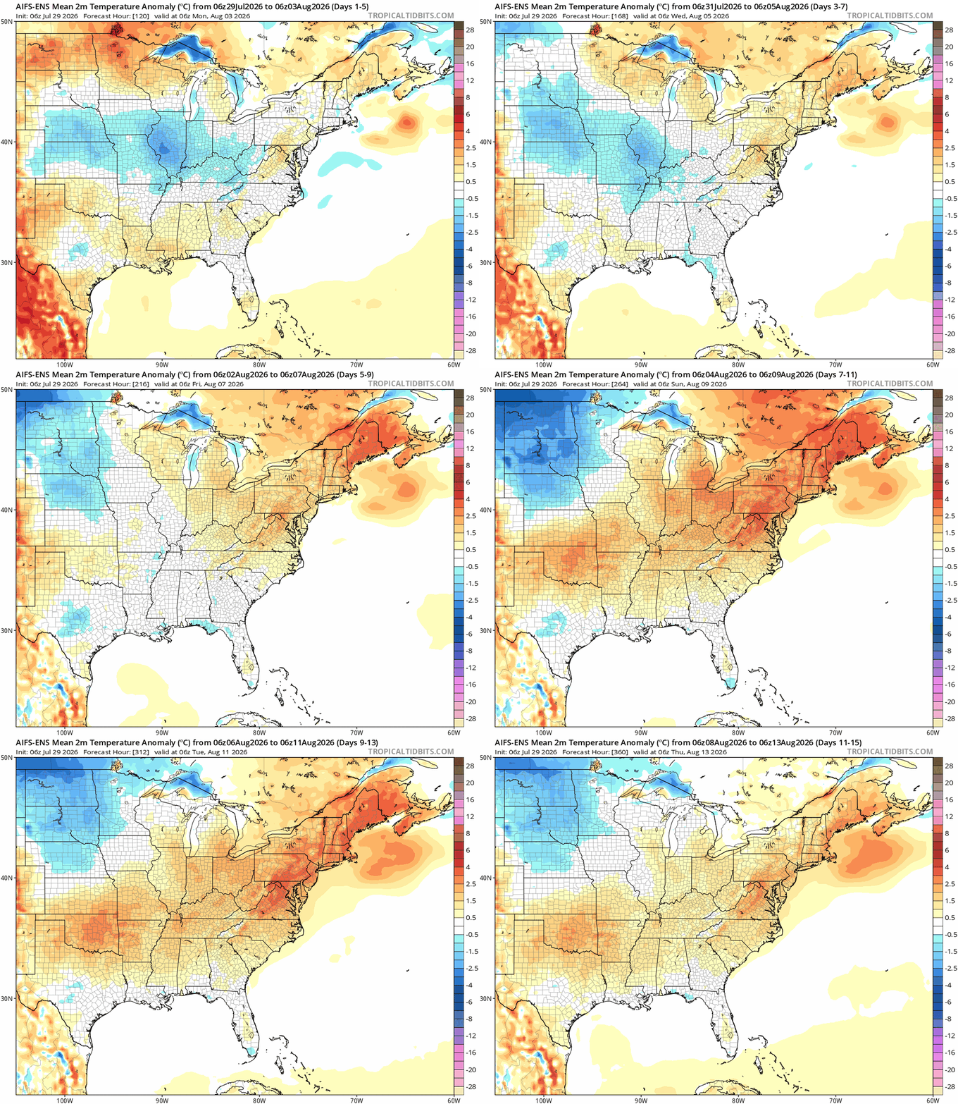
heat is coming back
-

2026-2027 Super El Nino
GaWx replied to Stormchaserchuck1's topic in Weather Forecasting and Discussion
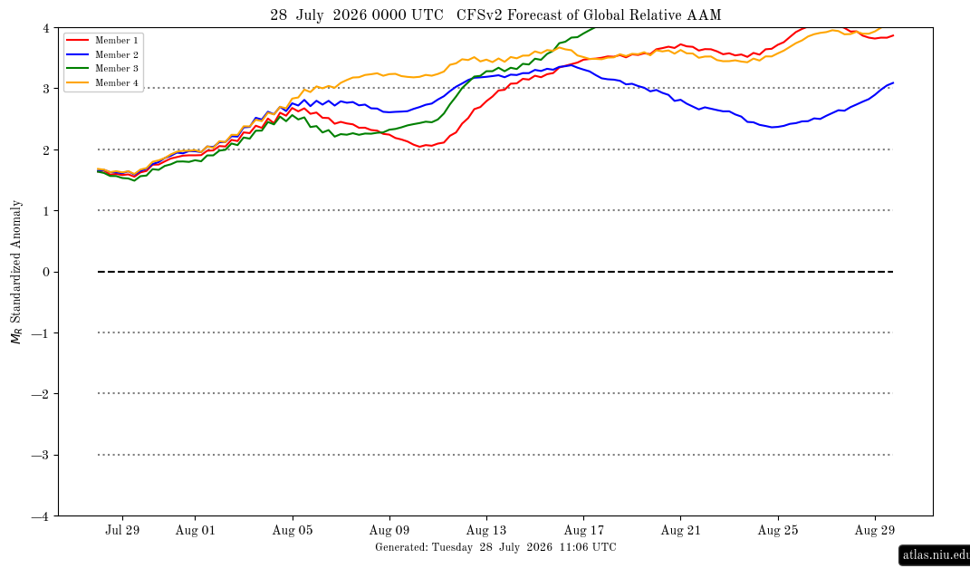
Going back to when I started following the CFSv2 AAM forecasts in Nov of 2023, the latest release (7/28/26 0Z) easily has THE strongest CFSv2 ensemble forecasted mean AAM of any I’ve ever seen/saved. The mean exceeds +2.5 by day 8 (Aug 5th), +3.0 by day 16 (Aug 13th), and +3.5 by day 20 (Aug 27th)! Although days 1-7 are a little shy of the strongest for week one of the forecast, all of the days day 8 to the end (day 32) are THE earliest periods in the forecast to get that strong. Granted these have a notable +AAM bias starting ~day 15 that rises further with time as I’ve noted a number of times. But regardless, this one is very strong by day 8, which is early enough to be fairly reliable, and this run is as I said the strongest of any run that I’ve seen as a whole, which bodes well for the chance for a very strong +AAM dominating at least through the 1st 1/2 of August: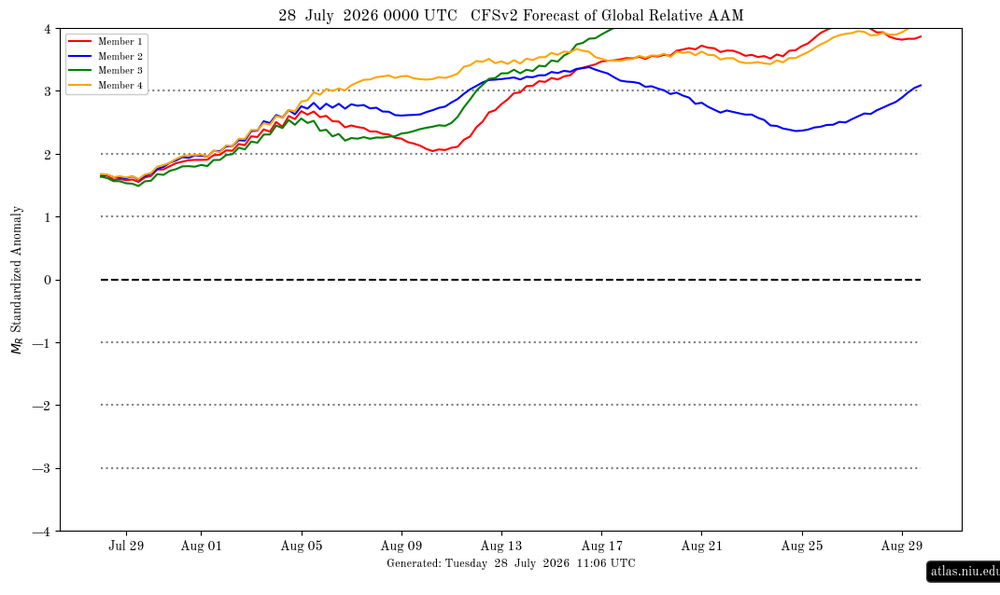
-
Historically, the SW US is a dry region. A few decades of wetter years allowed for strong pop growth. TBH, wouldn't surprise me to see ghost towns by century end, just like mining ghost towns. The water that gets pumped out of the ground leaves cavities empty, and they collapse. No longer able to refill. Some places are just not meant to have big pops.
-
 Acclimation can occur without moving a bit. Sometime next month or early September we'll have a morning in the mid-upper 30s and it will feel quite chilly. In January that would be shirtsleeve weather. The early heat this month hit hard due to tall dews and not having had much real heat before that. With several weeks of mostly CoC since then, another big heat next month will take some more acclimation. Could happen - we've had only 2 heat waves here, each 3 straight 90+, and one came last year. In 28 summers, we've had 90+ on 23 days. June leads with 9 and August is 2nd with 7. Only 3 in July and 2 each for May/September. 30 thunder days in AK? That's twice my average here and last year we had a mere 5. Go far NW for SVR?
 -
 Think near 15”.
 -
The next thing we will be tracking this afternoon is how unstable the atmosphere becomes with sunshine developing across parts of the region to the south and west of the LP . This will determine when , where and If T-storms develop and their eventual movement and intensity - stay tuned !
-
.89 here
-
 It was different...
-
 Ya it’s been a bit wet lol. Didn’t Kevin have a close to 20” July a few years back ?
 -

E PA/NJ/DE Summer 2026 Obs/Discussion
Birds~69 replied to PhiEaglesfan712's topic in Philadelphia Region
Was surprised, no doubt but makes sense. She's loaded, why not enjoy life before the dreaded If it wasn't announced yet her replacement will probably be a female although I would give Chris Sowers a call since he's back in the area and a snow guy... 73F/Damn DP 72F -
 1.87 at CEF so far for the event. Not sure how much more to follow.
 -

2026-2027 Super El Nino
George001 replied to Stormchaserchuck1's topic in Weather Forecasting and Discussion
Wow this was back in March, well done. Interestingly the spring predictability barrier went the other way in that guidance was underestimating the strength of the El Niño. Imo this was a very well predicted event, it tipped its hand early and guidance already was flagging a potential super Nino in late winter/early spring. The biggest events really do tip their hand early, I recall the subsurface began warming as early as February. At the time I didn’t think much of it, but in hindsight that was a sign of things to come. -
Fire Island?
-
My oldest just moved from Cathedral Heights. Told her about this from you.
-
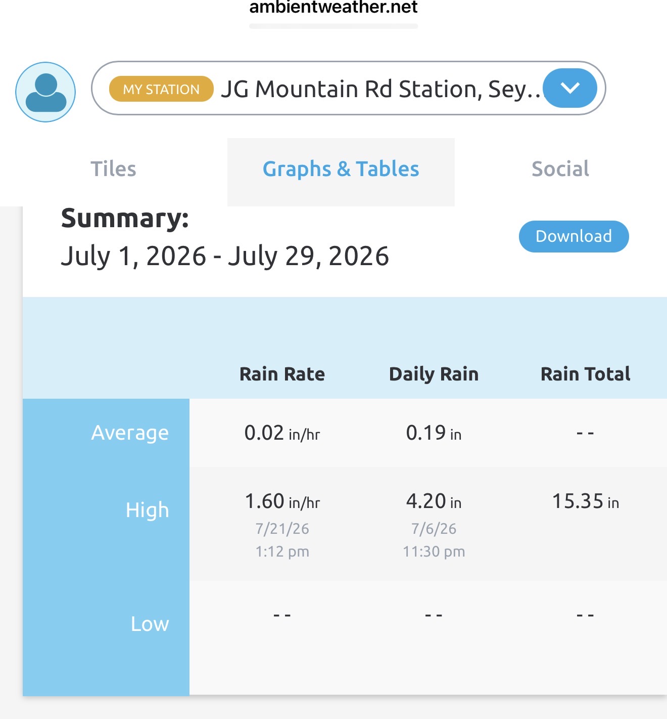
2.10" at my house on the stratus gauge, 2.13 on my ambient station. Shocked they were so close with the rain intensity at times. I see the cocorahs map got my total, nice.