All Activity
- Past hour
-

Central PA Winter 25/26 Discussion and Obs
mahantango#1 replied to MAG5035's topic in Upstate New York/Pennsylvania
High today was 35.2 -

Richmond Metro/Hampton Roads Area Discussion
wasnow215 replied to RIC Airport's topic in Mid Atlantic
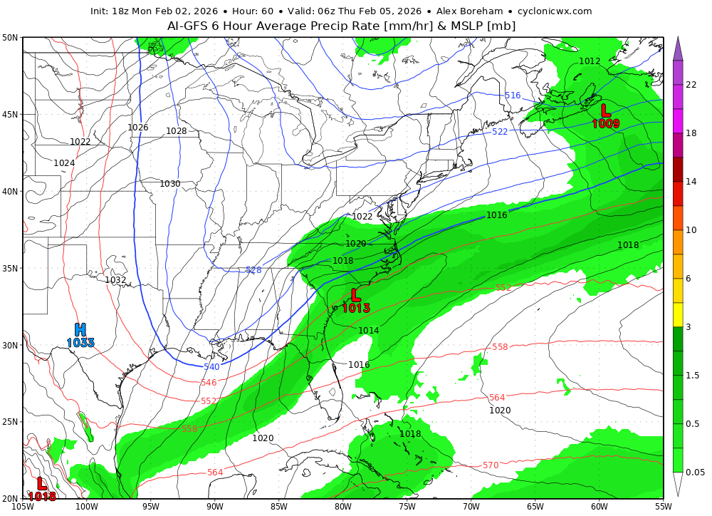
For tomorrow evening into Wednesday… Unless that low pressure develops like some of the models are showing and gets decently strong, there's no way that weak sauce is going to get over the mountains, to be anything more than some pithy snow showers or rain showers possibly for Richmond, because rates will be so poor. Highly unlikely we see any good snow out of this. -
Sun angle season is upon us
-
Back to 31 off a high of 34.
-
I'm rolling with the ARW. Gimmie another bourbon. Might go Panasonic. Does it have an 18z run?
-

January 30th- Feb 1st ULL and coastal storm obs
WinstonSalemArlington replied to JoshM's topic in Southeastern States
Truly Southeast: 57F/13.9C Guantanamo Bay Military Base All time low tied -
33.1 for my high and I was 32.0 or above from 1:45 until 3:20
-
AI Models look really good
-
 Sun did good work here, temp reached 31-32 from the morning low of -2. Bit of wind, though.
 -
When does the next WeatherNext come out.?
-
Yep. 15 minutes of snow after hours of rain.
-
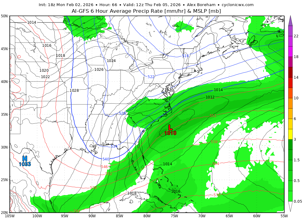
Trend on 18z GFS is there for sure! This thing is looking good for border counties into S.VA

.thumb.gif.2adee357f92e5e0f625035833dc51a22.gif)
-
 31 Stayed below today .Hopefully tomorrow too
 -
The AI GFS looks nice too
-

February 2026 OBS & Discussion
donsutherland1 replied to Stormlover74's topic in New York City Metro
The longest stretch of subfreezing days since 2017-18 ended today. The ECMWF weeklies show a distinct milder period of 1-2 weeks duration. Social media is suddenly abuzz about the warmth it has noticed. Still, there's no need to despair. Winter 2025-2026 has already delivered some genuinely great moments. Although those moments might be in the past, they cannot be erased by the forecast moderation that lies ahead beginning around February 10th. Some highlights: New York City experienced its coldest December-January period since 2014-2015. New York City saw an 11.4" snowfall with many areas outside the City picking up 12"-18". New York City has seen two highs in the teens and two lows in the single digits. Outside the City, numerous locations have experienced subzero lows. Ice and ice floes have reappeared in the Hudson River for the first time in years. In a wider perspective, parts of the Great Lakes Region saw a record November daily snowfall, Toronto experienced its biggest snowstorm on record, and parts of Georgia, South Carolina, and North Carolina enjoyed a generational snowstorm. Nothing is cast in stone. Model skill beyond two weeks is low. Forecast patterns can change. Sometimes abruptly. IMO, rather than riding an emotional roller-coaster with each turn of the models or allowing the most negative outcomes to drive winter's wonderful moments from memory, it's better to appreciate what we've already experienced and stay patient about what lies ahead. Spring will come. It always does. But Winter 2025-2026 may still bring additional cold and snowfall, even if the models cannot currently see the cold and snow at the long lead times involved. -
RGEM is killing it this year.
-

Winter 2025-26 Medium/Long Range Discussion
McHenrySnow replied to michsnowfreak's topic in Lakes/Ohio Valley
Light at the end of the tunnel? Are you fucking kidding me? -
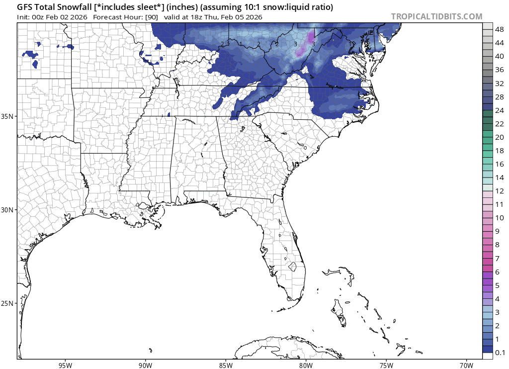
Yeah it's great to see that we could get accumulating snow even with the less amplified solutions knowing that a more amplified look would increase rates and crash temps even faster. That is, if the trough can stay sufficiently far south
-
That's the 18z NAM.
-

Central PA Winter 25/26 Discussion and Obs
canderson replied to MAG5035's topic in Upstate New York/Pennsylvania
Was saying this to a coworker today. If we get a big rain event we’re in for trouble. -

Jan 30th-February 1st 2026 Arctic Blast/ULL Snow OBS Thread.
Jed33 replied to John1122's topic in Tennessee Valley
Clouds kept the lid on the temps today. It was a pretty big bust on temps all around from morning lows to afternoon highs. Looks like it made it to 28 here but back down to 26 now. -
GFS also improved at 500. Much more expansive precip
-
18z GFS increases a little more from 12z.
-
It's kind of impressive how the Euro OP manages to engineer a way to avoid snow for the next 15 days. Barely a dusting in 2+ weeks. And it has support from the other globals and ensembles. In November, sure... but early Feb?!
-

February 2026 Medium/ Long Range Discussion: Buckle Up!
dallen7908 replied to Weather Will's topic in Mid Atlantic
Warmer as in multiple days in the 50s - may or may not make it to 60.


.gif.16a10b4a39e8aef355a8bfb64b665fbf.gif)


.thumb.jpg.9707d4addca3d84715ae3d888c5c10d6.jpg)

