All Activity
- Past hour
-
Backing in.
-

Winter 2025-26 Medium/Long Range Discussion
Malacka11 replied to michsnowfreak's topic in Lakes/Ohio Valley
Ik it's been a pretty standout year for Chicago lake effect events but I'm pretty happy with the bonuses I've received here in westmont so far. I think snow cover has been far more consistent than back home in Aurora and I'm pleasantly surprised. It's definitely kept me from cad posting -

The “I bring the mojo” Jan 30-Feb 1 potential winter storm
StantonParkHoya replied to lilj4425's topic in Southeastern States
FYI -- you can converse with Weather Next 2 via Gemini. It think the SLP forms too far off the coast and phases too late with precip confined to coastal NC. -

E PA/NJ/DE Winter 2025-26 Obs/Discussion
The Iceman replied to LVblizzard's topic in Philadelphia Region
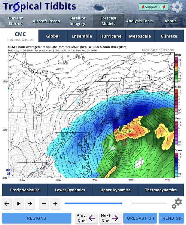
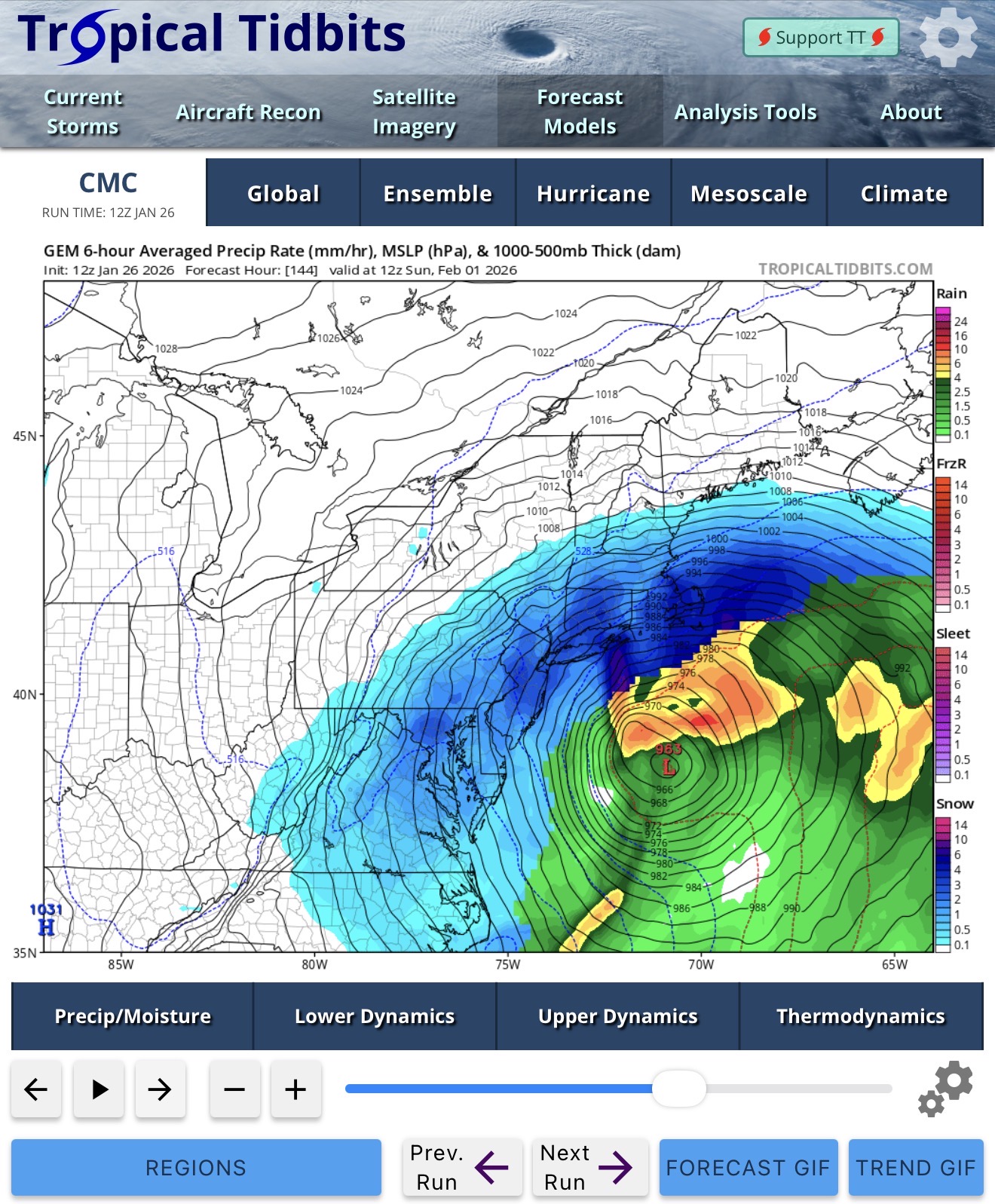
963 at the benchmark . I’m with Heisy, I think I'm more concerned with a super tucked solution than a miss east at this point.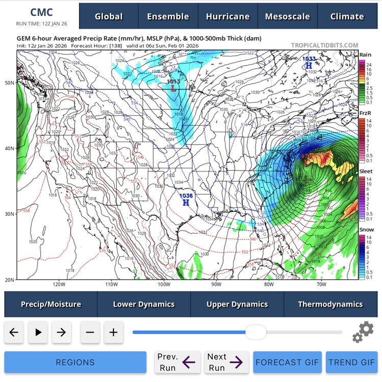
-

Pittsburgh/Western PA WINTER ‘25/‘26
Rd9108 replied to Burghblizz's topic in Upstate New York/Pennsylvania
I mean I never said I wouldn't track it but I certainly wont be upset if we miss. Curious to see what the euros show today. -
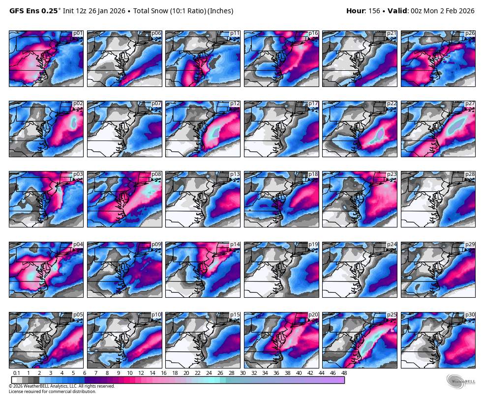
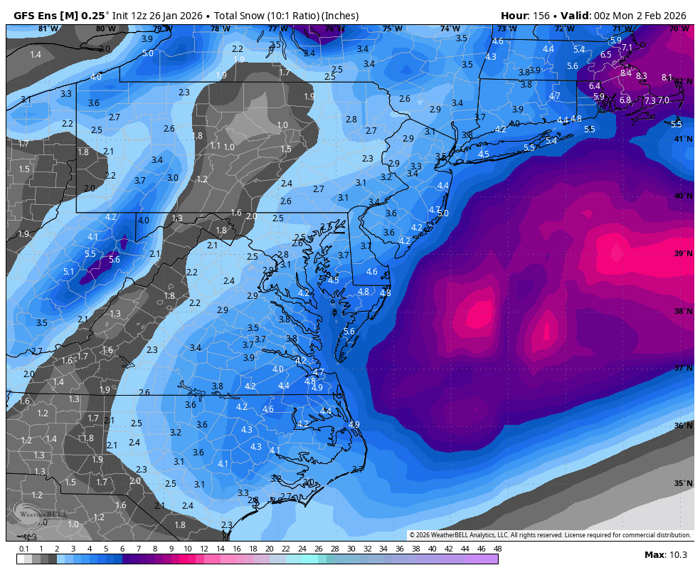
GEFS backing that wagon up on the 12z run. Like the look for now, considering how far out we are in time.
-

E PA/NJ/DE Winter 2025-26 Obs/Discussion
Duca892 replied to LVblizzard's topic in Philadelphia Region
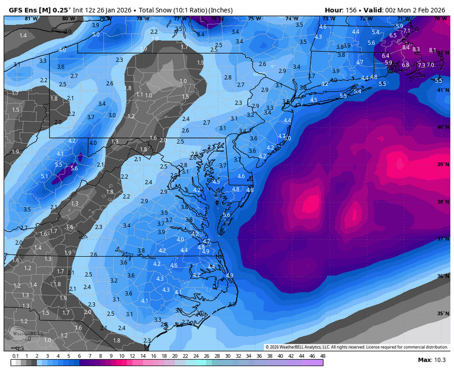
GFS ENS were posted in the MA forums definitely an improvement over 6z -
About 14 mins from euro ai. Hopefully it’s similar to the 6z beat down
-
 I’d be shocked if you didn’t grab at least 2”. Could be 3-5” if you get into some nice fluff bands this evening. IVT seems to enhance the dPVA snows as they hit eastern areas after 21z.
 -
GFS ENS definitely a step in the right direction
-

The “I bring the mojo” Jan 30-Feb 1 potential winter storm
Omen replied to lilj4425's topic in Southeastern States
00z to 12z GEFS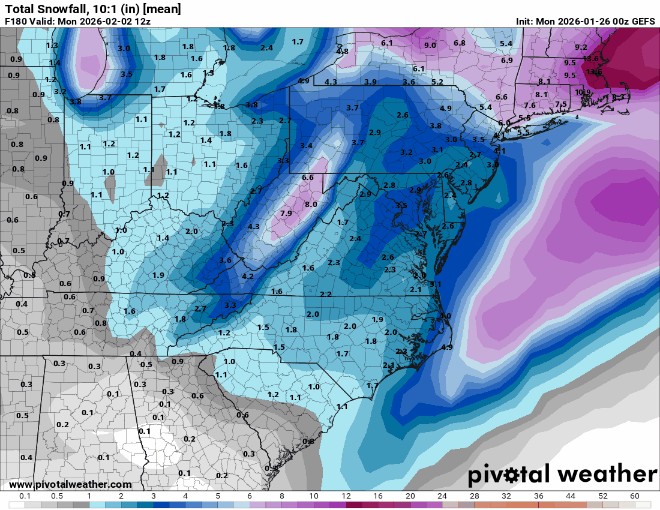
-
Appreciate the quick post with comparison, Will. Trend is our friend here. Based on MSLP maps there was a good shift of members towards the coast. Baby steps!
-
Improvement. Take it. Not gonna come all at once.
-
Nice! Rjay threads are usually good luck too lol
-
Rooting for George now!
-
 Got one for EEN? Sent from my SM-S166V using Tapatalk
 -
 Hoping for 1-3 here this aftn and evening.
 -

Pittsburgh/Western PA WINTER ‘25/‘26
MikeB_01 replied to Burghblizz's topic in Upstate New York/Pennsylvania
i too am feeling the withdrawal. So anything out there to track, im in -

January 2026 Short/Medium Range Thread
Holston_River_Rambler replied to John1122's topic in Tennessee Valley
Just as an example, look at this sigma anomaly (standard deviation from the norm). -
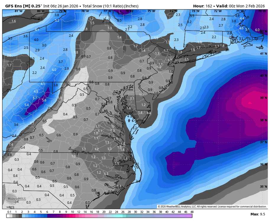
WB 12Z GEFS; last picture compared to 6Z.

-

January 2026 OBS and Discussion
Ridgewoodweather125 replied to TriPol's topic in New York City Metro
Thank you; thinking I may book a flight late Saturday just as protection if it ends up being needed -
Im at 13" right now... The airmass not budging yesterday porked me with rates, steady snow now though Sent from my SM-S166V using Tapatalk
-

2025-2026 ENSO
so_whats_happening replied to 40/70 Benchmark's topic in Weather Forecasting and Discussion
If you click on the link I provided it is important to note there are not a lot of examples to determine either ENSO neutral or Nina of a solid phase 1 passage in February and the resulting effects. Nino is not there at all which is a bit strange. If you look at the Nina depiction it is a big cold press into the east based of the 500mb pattern with a follow of warming into the plains which would alleviate much of the east at some point. Do I think it will happen, well I honestly would not be surprised if we relax the cold pattern a bit but im not expecting torch like behavior. To me it seems the results are more of a mixed bag and could easily be explained by other more prevalent signals such as PDO/ PNA/WPO/ NAO etc. If we do indeed get this SPV split all bets are off into either direction of where we go but one would assume we tend to re enforce the pattern we currently would have leading into the split. -
Flurries in lower manhattan
-

Jan 17-18 Sunday Funday Storm
WinstonSalemArlington replied to NorthHillsWx's topic in Southeastern States


.thumb.jpeg.1d2958065f007d9e7218a8c935ea8246.jpeg)