All Activity
- Past hour
-

2026 Mid-Atlantic Severe Storm General Discussion
SnowenOutThere replied to Kmlwx's topic in Mid Atlantic
To my relatively novice eyes the 0z NAM run looks primed. Lapse rates, decent enough cape, and ofc insane shear. -
You can search them by date here https://mesonet.agron.iastate.edu/wx/afos/list.phtml
-
I can’t handle the stress anymore. My nerves are shot. I’d go if others are in charge of driving and navigation / radar monitoring. I just want to be able to take footage.
-
Huge difference in E IA between NAM and 3K.
-
58.3 for the high
-
NW trend took me out of the ice and put me in the severe risk. Most likely elevated storms over a cold surface layer yet again. Don’t need any more heavy rain at the moment. Pre-greenup season really amplifies the effects of precip anomalies. Too dry you get fires, too wet you get floods.
-
That is insane for synoptic wind! After long stretch of mostly uneventful weather, this March has been anything but boring.
-

2026 Mid-Atlantic Severe Storm General Discussion
wxmeddler replied to Kmlwx's topic in Mid Atlantic
I'm fairly well convinced that the recent SPC changes have fundamentally altered the way higher percentages are given out. So much so that most of the SPC climatology is going to have to be tossed / step-changed. Arguably for the better though! SPC Forecasters have repeatedly said that the % were under-done due to the way the rubric was constructed. That's why things like NadoCast and PPF's were always markedly higher. New 30%D3 is the old 15%. And that's good! I think it better conveys the actual risk. It's just going to get some getting used to. -
SBN’s top gust was 68 mph today.
-
Crazy to see the hatched area include most of the marginal risk areas as well.
-
Well it looks like we found an answer to no PNS from BOX pre 1997.. it's there just under a different product name OPU. I just checked jan 1996 is there, Feb 1995 is there. Thanks to @vortex95for that. Big help. Looks like I'll have to go back and re do all the storms pre 1997 that I didn't have BOX and ALY PNS for which will help a lot. They are all on the IEM site.
-
I’ll be there 4/11
-
That's about a good of a definition of the two tornado alleys as you can get.
-
Not really a good N. Hemisphere 500mb pattern until the NAO goes negative the last week of March ENSEMBLE LOOP The SW, US ridge as a dominant factor is the best going for us, as a we drop a trough over and east of it, the pattern of the Winter.
- Today
-
Early March Stratosphere warming is starting to connect with -NAO on long range models towards the end of March.
-

Pittsburgh/Western PA WINTER ‘25/‘26
Rd9108 replied to Burghblizz's topic in Upstate New York/Pennsylvania
This is the third time this year my power has gown out. Im getting sick of this. -

2026 Mid-Atlantic Severe Storm General Discussion
Eskimo Joe replied to Kmlwx's topic in Mid Atlantic
- 187 replies
-
- 1
-

-
- severe
- thunderstorms
- (and 7 more)
-
Tree branches down all over the place in silver spring. I guess lots were weakened by heavy wet snow this month and last. And our very cold winter and recent freeze/thaw/boil cycle.
-
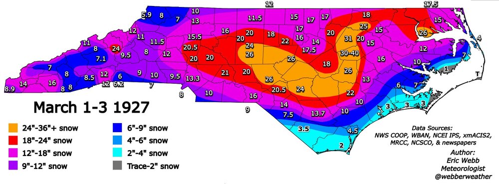
Check out these historical snowstorms for NC: https://x.com/webberweather/status/2017664133848830174 https://x.com/webberweather/status/2017748647543509317 The March 1927 event - HOLY ( )!!!, and we thought what happened this season was impressive in NC?? So you may want to contact this person as to where and how gets all his snowfall data. Actually, he lists his sources on the snowfall map attached! I think there is a lot data out there you could use to produce in detail many pre mid-1990s events for SNE.
-
Hrrr coming back south a bit. Making me cautiously optimistic that I might actually end up in the bullseye for MSP on this one. .
-
.thumb.jpg.6a4895b2a43f87359e4e7d04a6fa0d14.jpg)
Central PA Spring 2026 Discussion/Obs Thread
Yardstickgozinya replied to Voyager's topic in Upstate New York/Pennsylvania
Yes, I may have a wrong picture, but one is coming together. Lol I believe the storm was cycling in the signatures that @mahantango#1 posted and we're seeing the very moment the old inflow, notch closed up. I also believe the storm probably cycled like this several times before it could form a tornado. @MAG5035 feel free to to let me down.
-
I don’t want prolonged cold weather, but for the sake of competition, I’m open to a hot vort that slides through southern/central Va with a transient hp overhead.
-
We should start another dead end thread.... in all seriousness, I would be excited for this period if it were not the end of March: teleconnections are decent with - WPO, + PNA, AO neutral, and - NAO; MJO progression 8-1-2; cold air to tap with anomalies 20 degrees plus below normal. It could all fall apart tomorrow but will be watching....
-

2025-2026 Fall/Winter Mountain Thread
Maggie Valley Steve replied to Buckethead's topic in Southeastern States
The 18Z GFS suggests an inch or two of snow for many including the SW Mountains. It certainly looks like an expressive shot of Canadian air arrives Monday into Wednesday!.thumb.png.df177d5bbbfc2938e6a888f148d1226f.png)
-
FYI, this winter thus far has two interesting parallels to the winter of 1989-90 in the Mid-Atlantic. (1) A major consecutive day streak in which the maximum temperature failed to reach the freezing mark at DCA: December 16-25, 1989 and January 24-February 1, 2026 (2) A March mini heat wave in which the maximum temperature soared way above normal at DCA: March 12-16, 1990 maximums were 89, 87, 86, 81 and 81 and March 8-12, 2026 maximums were 76, 76, 84, 86, and 78 So, what happened right after the March 1990 mini heat wave? Several minor snow events between March 20-April 7, 1990 totaling 0.2 inches at RIC, 2.6 at DCA, 2.8 at BWI, and 10.4 at IAD.


.png.a788da1f31b99c53d6630a57c194d263.png)
