All Activity
- Past hour
-
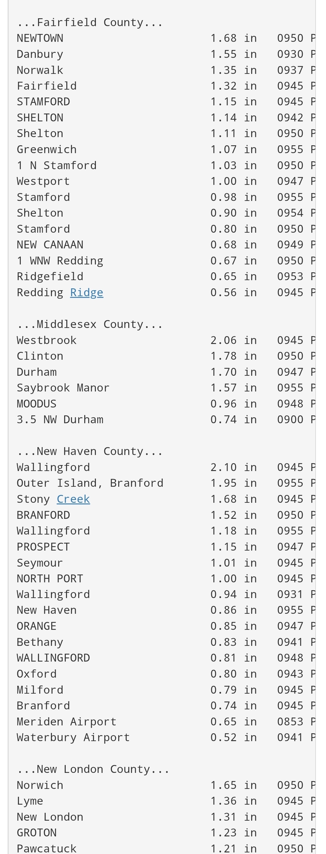
 Huge COC today into tomorrow
 -
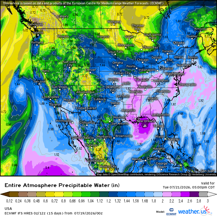
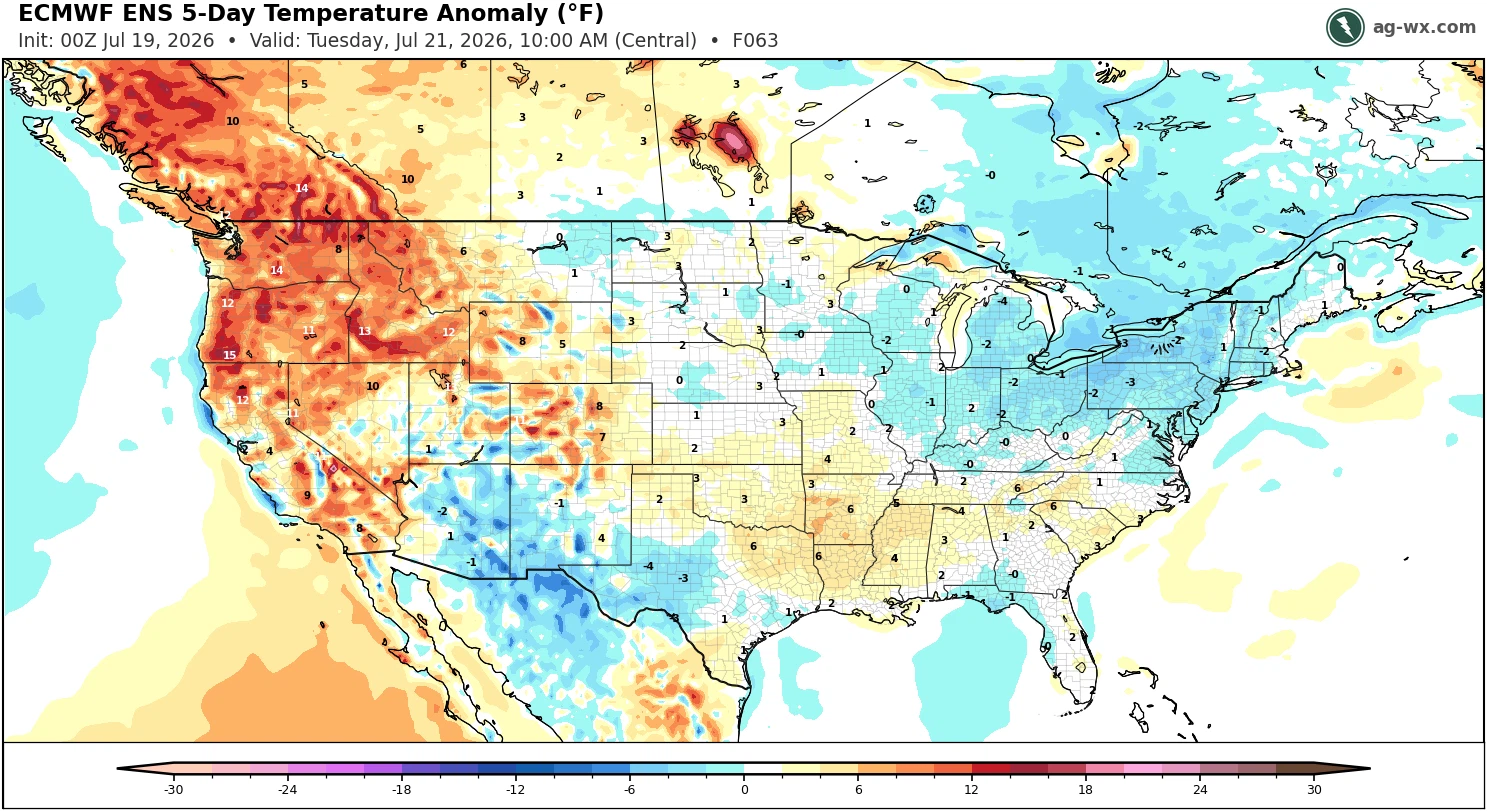
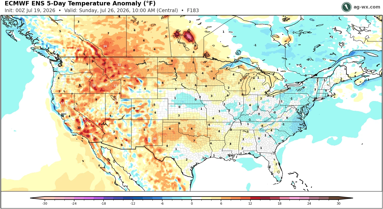
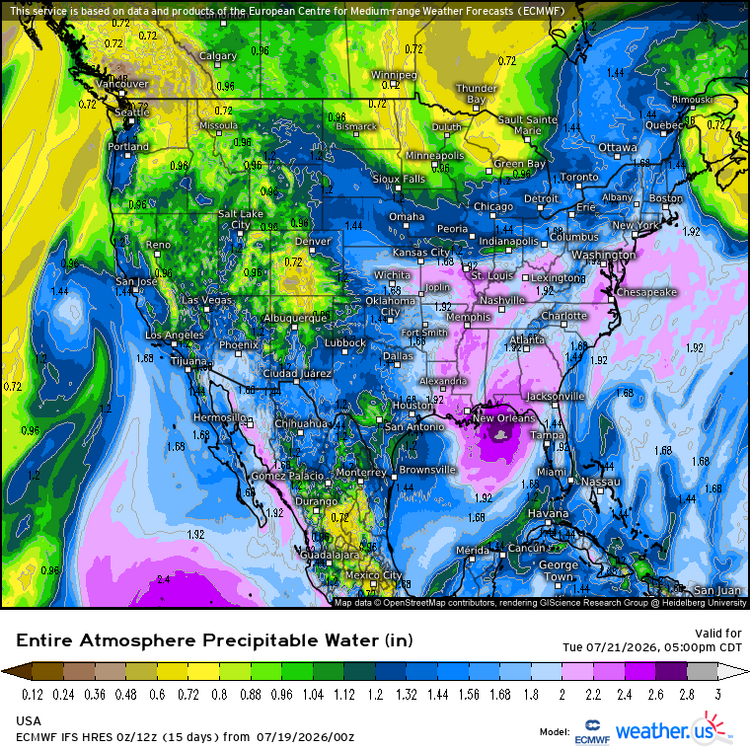
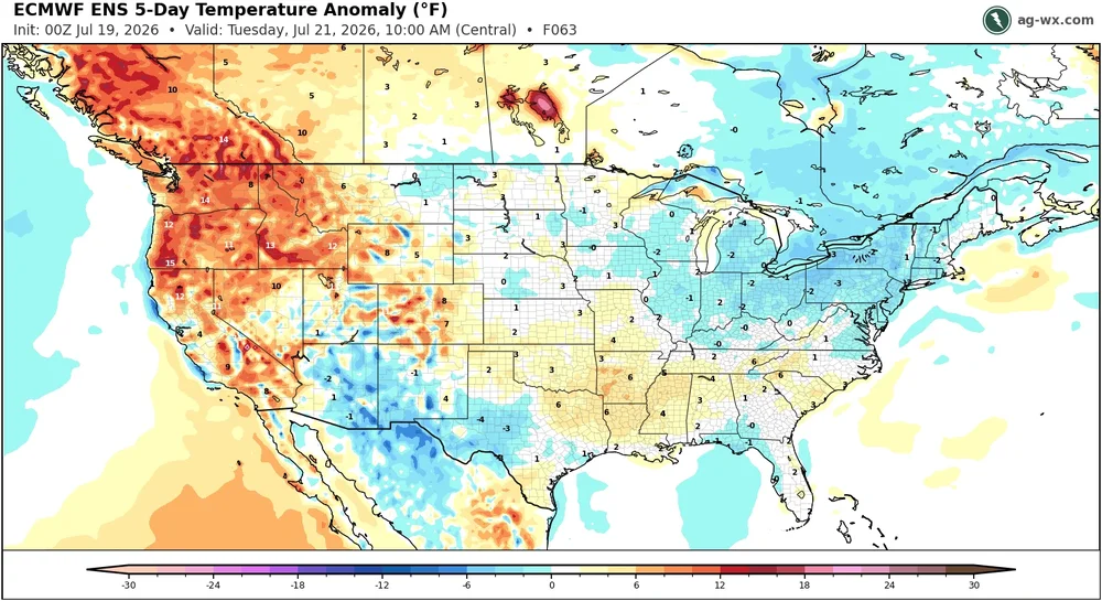
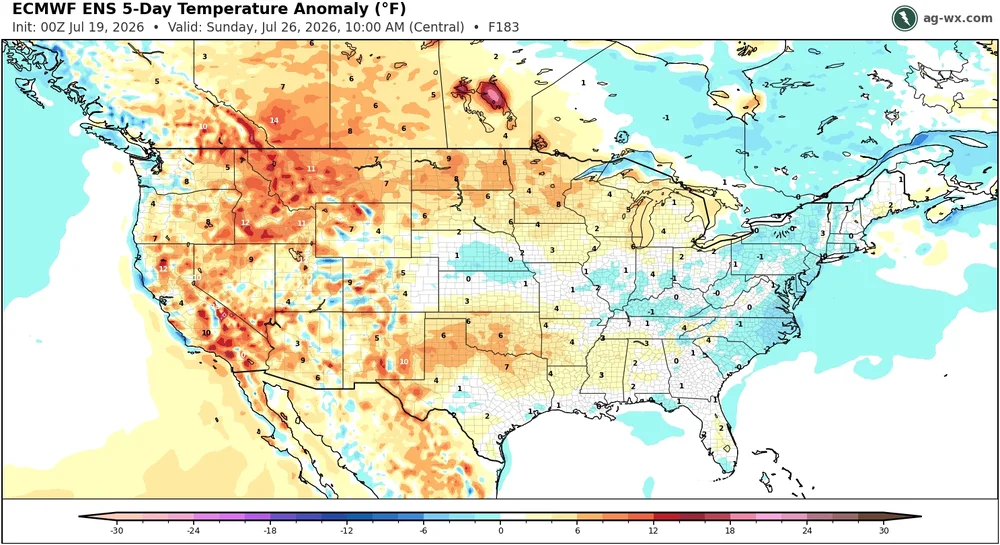
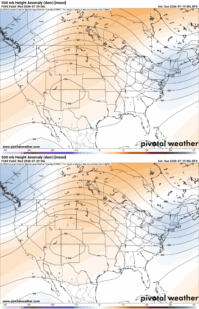
Another opportunity for a soaking rain event Tuesday into Wednesday. A PRE-like feature could develop from the tropical system in the Gulf. Generally cooler conditions the rest of the month with a trough in the East. Possibly more rainfall chances during this period. So multiple stations are on track for their wettest month in a while. Then we wait and see what pattern emerges after this as we head into August.
-
.thumb.jpg.6a4895b2a43f87359e4e7d04a6fa0d14.jpg)
Central PA Summer 2026 Discussion/Obs Thread
Yardstickgozinya replied to Voyager's topic in Upstate New York/Pennsylvania
This video has some really fascinating info on the geology of eastern Pa and the Susquahanna river. I had no idea that many of us were living on a piece of Africa that returned after the breakup of Pangaea or that the Little Atlas Mountains in Morocco and the Appalachian mountains were once the same chain. -
Went back and got last years July total to compare to this July so far. July 2025 2.73” July TD 2026 7.76” I know that Frederick seems to be the rain magnet to some but it usually is the Northern part of the county that gets the big totals. The Southern part, especially the SW portion has hit the jackpot this summer though.
-
 Not even .2 yesterday. The Stein rages on.
 -

Central PA Summer 2026 Discussion/Obs Thread
mahantango#1 replied to Voyager's topic in Upstate New York/Pennsylvania
.68 rain yesterday. -
Central PA Summer 2026 Discussion/Obs Thread
Yardstickgozinya replied to Voyager's topic in Upstate New York/Pennsylvania
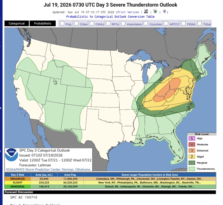
Day 3 Convective Outlook NWS Storm Prediction Center Norman OK 0210 AM CDT Sun Jul 19 2026 Valid 211200Z - 221200Z ...THERE IS AN ENHANCED RISK OF SEVERE THUNDERSTORMS ACROSS THE OHIO VALLEY... ...SUMMARY... Numerous severe thunderstorms are expected across a broad region from the Ohio Valley into the Mid-Atlantic and Northeast on Tuesday. All severe hazards are possible, but swaths of damaging wind gusts should be the primary severe risk Tuesday afternoon into the nighttime hours. ...Ohio Valley to the Mid-Atlantic/Northeast... A vigorous upper trough will spread across the region on Tuesday. A broad area of strong deep-layer flow, especially by July standards, will overlap a very moist airmass ahead of an eastward progressing surface cold front. Widespread dewpoints in the upper 60s to low 70s are expected. While some uncertainty exists regarding potential morning convection in the form of a remnant MCS from the Day 2/Monday period across parts of MI/IN/OH, pockets of stronger heating should occur, and given rich moisture/continuous warm advection ahead of the surface front, strong destabilization is forecast. While boundary layer moisture will begin the day somewhat muted across parts of the Northeast, strong warm advection and increasing southerly low-level flow across the Mid-Atlantic into the Northeast will also result in northward transport of richer boundary layer moisture through evening. While instability may be somewhat less further east into the Mid-Atlantic/Northeast, strong deep-layer flow will envelop this region as well. Supercell wind profiles are evident across the broad warm sector, with 40+ kt westerly flow common above 850 mb. Where supercells can develop and be maintained, all severe hazards will be possible. However, given the strong flow field, and the progressive trough and surface front, one or more bowing segments will quickly develop and spread eastward. Swaths of damaging winds will be the primary concern during the afternoon and into the nighttime hours. ..Leitman.. 07/19/2026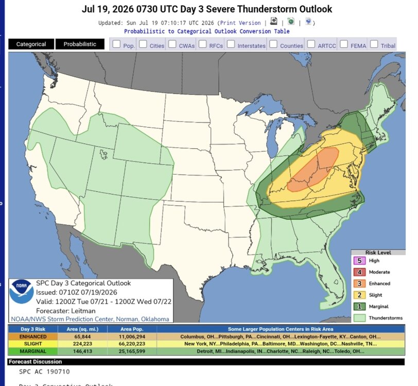
-
Saturday, July 18, 2026 Thunderstorm/Severe Weather Potential
CoastalWx replied to weatherwiz's topic in New England
Stein and fail -

Saturday, July 18, 2026 Thunderstorm/Severe Weather Potential
Damage In Tolland replied to weatherwiz's topic in New England
.39. Stein Onto next Steiner on Tuesday -

Central PA Summer 2026 Discussion/Obs Thread
pawatch replied to Voyager's topic in Upstate New York/Pennsylvania
65 degrees this morning…Little bit better day! I picked up .43” of rain yesterday, we lucked out on the wind. We didn’t hardly have any of that. The highest wind gust was 20 miles an hour. There was a whole lot of thunder and lightning. I got mow number 18 in for the year yesterday, before the rain yesterday. -
1.16” total imby/Columbia on July 18. —0.11” during pre-dawn t-shower —1.00” for late afternoon t-storm —0.05” Saturday evening after t-storm 4.44” so far in July.
-

2026-2027 Super El Nino
bluewave replied to Stormchaserchuck1's topic in Weather Forecasting and Discussion
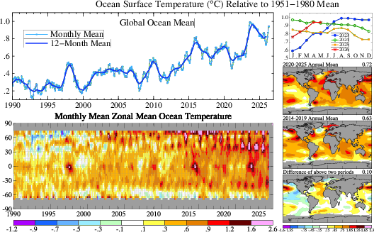
It temporarily removes warmth from around the equator in the ENSO regions. But the heat release following each super El Niño finds its way into the adjacent oceans and land areas. You can see how the oceanic and atmospheric heat increases following each El Niño back to 1997-1998. This is why the global baseline temperature sets a new record during each super El Niño. The temperatures pullback slightly in the following years but a well above the previous years which were neutral or La Niña. The 1997-1998 event below was followed by warming in the Arctic. The heat release from the ENSO regions in 2015-2016 founds its way into the 30N to 60N mid-latitude regions. This is the persistent -PDO that we have seen since around 2019. Also notice how the Nino 1+2 and other regions didn’t fully release all the heat following the 2023-2024 before recharging with more heat only 3 years apart. So this is a first in our modern climate era. That’s why when I saw the record WWBs in the spring it wasn’t a surprise when the ENSO forecasts started showing another super El Niño so soon. So the big to watch story going forward following this strongest event on record is what areas will see the greatest temp jumps in the late 2020s?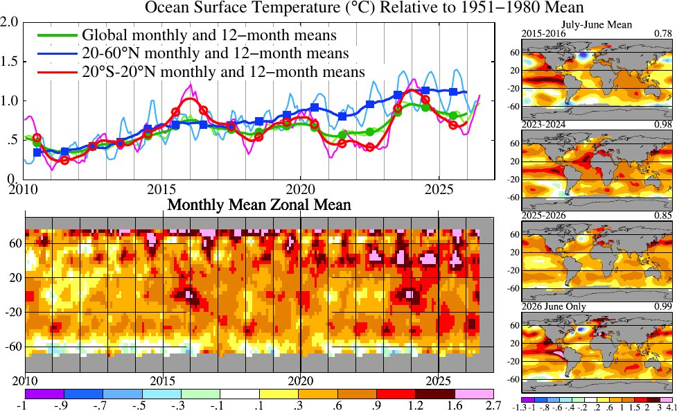
-

Saturday, July 18, 2026 Thunderstorm/Severe Weather Potential
BrianW replied to weatherwiz's topic in New England
Another good drenching for the coast. 1.87 here and 5.46 mtd.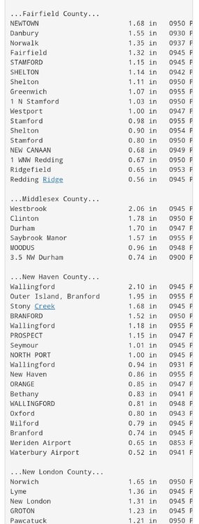
-

Saturday, July 18, 2026 Thunderstorm/Severe Weather Potential
Baroclinic Zone replied to weatherwiz's topic in New England
Maybe 0.4” here. Take it. -

2026-2027 Super El Nino
mitchnick replied to Stormchaserchuck1's topic in Weather Forecasting and Discussion
This is December. Loop through it. They're not bad thanks to lower heights. Edit: NNE is obviously warmer as in most moderate or strong Niños https://www.tropicaltidbits.com/analysis/models/?model=cfs-mon®ion=eus&pkg=T2ma&runtime=2026071818&fh=5 2nd Edit: Here's the link to 850 temps starting December https://www.tropicaltidbits.com/analysis/models/?model=cfs-mon®ion=us&pkg=T850a&runtime=2026071818&fh=5 -
The luck of the draw also dealt me a losing hand yesterday but this was a model loser since Thursday, therefore, I was not surprised. NWS high probs. really don't count anymore. Monterey received .92" and Marlinton W.Va. got 1.59".
- Today
-

2026-2027 Super El Nino
SnoSki14 replied to Stormchaserchuck1's topic in Weather Forecasting and Discussion
The lower heights doesn't mean it will be cold given the super Nino. -
2026-2027 Super El Nino
mitchnick replied to Stormchaserchuck1's topic in Weather Forecasting and Discussion
I'll say this: Cfs2 continues to advertise a decent with pattern in the east this winter, including the illusive, albeit displaced at times, Aleutian Low. This is the link starting December. Loop through it and you'll see what I mean. https://www.tropicaltidbits.com/analysis/models/?model=cfs-mon®ion=namer&pkg=z500a&runtime=2026071818&fh=5 P.s. April looks near perfect too! -

Saturday, July 18, 2026 Thunderstorm/Severe Weather Potential
SouthCoastMA replied to weatherwiz's topic in New England
1.00" on the dot looks like 2-3" for ewb, Falmouth, mvy -

Chester County PA - Analytical Battle of Actual vs. Altered Climate Data
chubbs replied to ChescoWx's topic in Climate Change
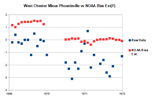
Your AI isn't very well informed about the changes with time at the Chester County COOP stations. That's on you. Garbage in, Garbage out. The raw data clearly shows that Coatesville, Phoenixville, and West Chester cooled by roughly 2F after station moves in the 1946-70 period.. As discussed above, The roughly 2F cooling at the 3 Chesco COOPs matches the 2F cooling relative to ABE. The station move cooling isn't a small change. Very easy to see in the raw data.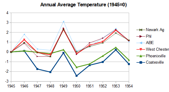
-
Day 3 Convective Outlook NWS Storm Prediction Center Norman OK 0210 AM CDT Sun Jul 19 2026 Valid 211200Z - 221200Z ...THERE IS AN ENHANCED RISK OF SEVERE THUNDERSTORMS ACROSS THE OHIO VALLEY... ...SUMMARY... Numerous severe thunderstorms are expected across a broad region from the Ohio Valley into the Mid-Atlantic and Northeast on Tuesday. All severe hazards are possible, but swaths of damaging wind gusts should be the primary severe risk Tuesday afternoon into the nighttime hours. ...Ohio Valley to the Mid-Atlantic/Northeast... A vigorous upper trough will spread across the region on Tuesday. A broad area of strong deep-layer flow, especially by July standards, will overlap a very moist airmass ahead of an eastward progressing surface cold front. Widespread dewpoints in the upper 60s to low 70s are expected. While some uncertainty exists regarding potential morning convection in the form of a remnant MCS from the Day 2/Monday period across parts of MI/IN/OH, pockets of stronger heating should occur, and given rich moisture/continuous warm advection ahead of the surface front, strong destabilization is forecast. While boundary layer moisture will begin the day somewhat muted across parts of the Northeast, strong warm advection and increasing southerly low-level flow across the Mid-Atlantic into the Northeast will also result in northward transport of richer boundary layer moisture through evening. While instability may be somewhat less further east into the Mid-Atlantic/Northeast, strong deep-layer flow will envelop this region as well. Supercell wind profiles are evident across the broad warm sector, with 40+ kt westerly flow common above 850 mb. Where supercells can develop and be maintained, all severe hazards will be possible. However, given the strong flow field, and the progressive trough and surface front, one or more bowing segments will quickly develop and spread eastward. Swaths of damaging winds will be the primary concern during the afternoon and into the nighttime hours. ..Leitman.. 07/19/2026
-
That escalated quickly for Tuesday...
-
 Yes. The smoke after the rain was very noticable.
 -
 Whenever you require safe shipping, this international supplier is the best bet.
 -
Woke up to a thunderstorm rolling over right now. Had 3 rounds of rain yesterday that put down half an inch or so. This one is small but it's pouring down. Looks like another, bigger one lined up behind this one if it doesn't die out.