All Activity
- Past hour
-

“Cory’s in LA! Let’s MECS!” Jan. 24-26 Disco
Damage In Tolland replied to TheSnowman's topic in New England
Anyone want to guess ground zero for zr / damage / outages? Yesterday I thought Aiken, SC. Today maybe Nashville ? -
Europe does have every reason to stick it to us from their view point * not political .
-

January 25/26 Jimbo Back Surgery Storm
NorthHillsWx replied to Jimbo!'s topic in Southeastern States
Yep and that’s in line with most predictions. Even conservative WRAL is going with 0.5-1” here in Raleigh which is pretty wild for them -

Central PA Winter 25/26 Discussion and Obs
Storm Clouds replied to MAG5035's topic in Upstate New York/Pennsylvania
When is the supposed start time Saturday night for western PA? Asking for a friend haha… -
Speaking of the hurricane hunters data now contained in the models…….I don’t remember where I saw this, but it said that GFS would incorporate the data from the dropsondes, and that the data would be made available to the other global programs. , and it would be up to them if they wanted to include it in their model runs. Maybe…..just maybe Euro said “no thanks” and that’s why it’s sticking to the same solutions over and over??? Somebody please correct me if I’m wrong or have additional insight. .
-

Possible Record Breaking Cold + Snow Sunday 1/25 - Tuesday 1/27
EasternLI replied to TriPol's topic in New York City Metro
Just get that 850 low to transfer south of us. Cuts off the warming and keeps the moisture feed going. I'd like to see more of that on the 00z runs. -

Possible Record Breaking Cold + Snow Sunday 1/25 - Tuesday 1/27
NJwx85 replied to TriPol's topic in New York City Metro
Yes, but the Euro used to be way ahead the rest of the pack so you could trust it more. I’m not arguing that model skill hasn’t improved, just that it’s harder to decipher what’s more correct at any given range, especially when the differences between the GFS and Euro are significant. This particular setup though is much easier to handle than a miller A that we might get next week. -

Pittsburgh/Western PA WINTER ‘25/‘26
Ahoff replied to Burghblizz's topic in Upstate New York/Pennsylvania
Went up again to 13"? -
Not really seeing it myself. What you see as a slight step I see as slight run to run noise. The snowfall maps are worse other than places NW of I-95, whether you choose to use the 10:1 or Kuchera. Not a massive difference but this run is not a move towards the GFS in a sensible weather context, and that's all that matters at this point.
-

January 24-26: Miracle or Mirage JV/Banter Thread!
Paleocene replied to SnowenOutThere's topic in Mid Atlantic
Can't believe we have to do another day of model watching all day tomorrow. Then radar hallucinations and short range cliff jumping on Saturday. Some may not survive -

2025-2026 ENSO
donsutherland1 replied to 40/70 Benchmark's topic in Weather Forecasting and Discussion
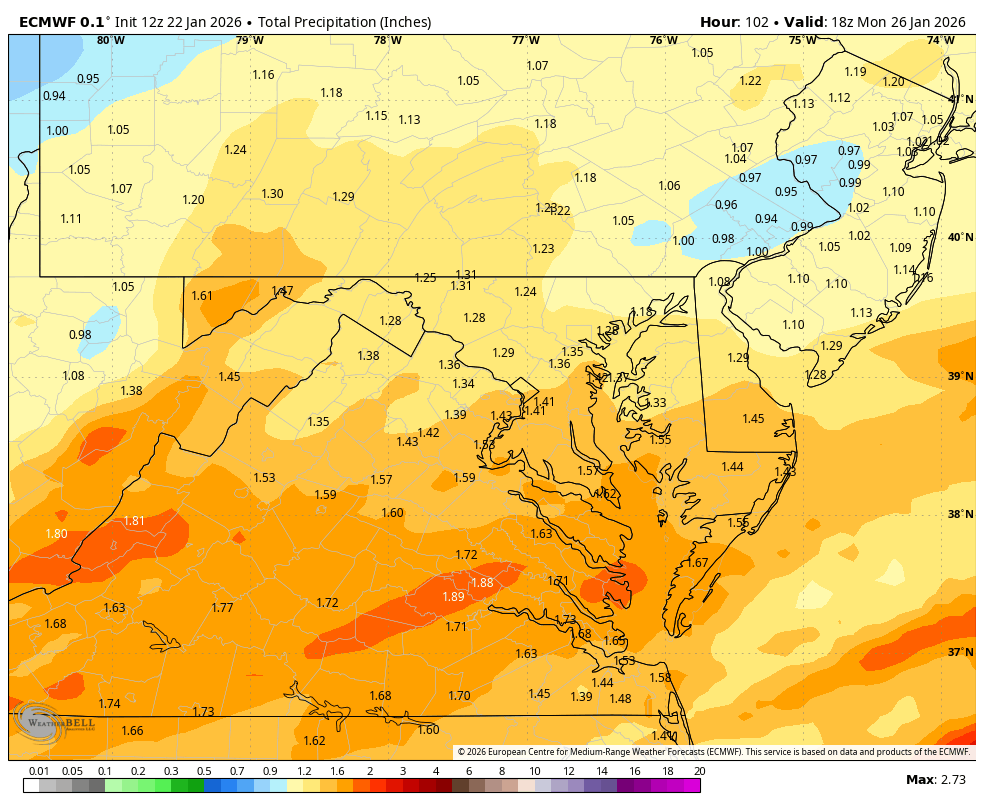
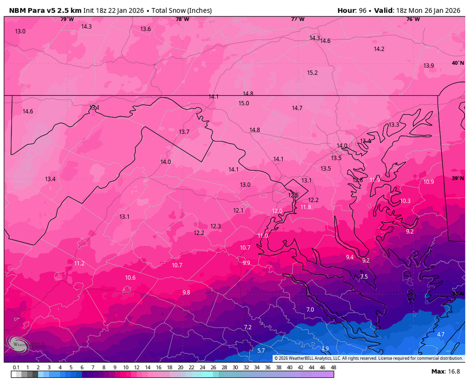
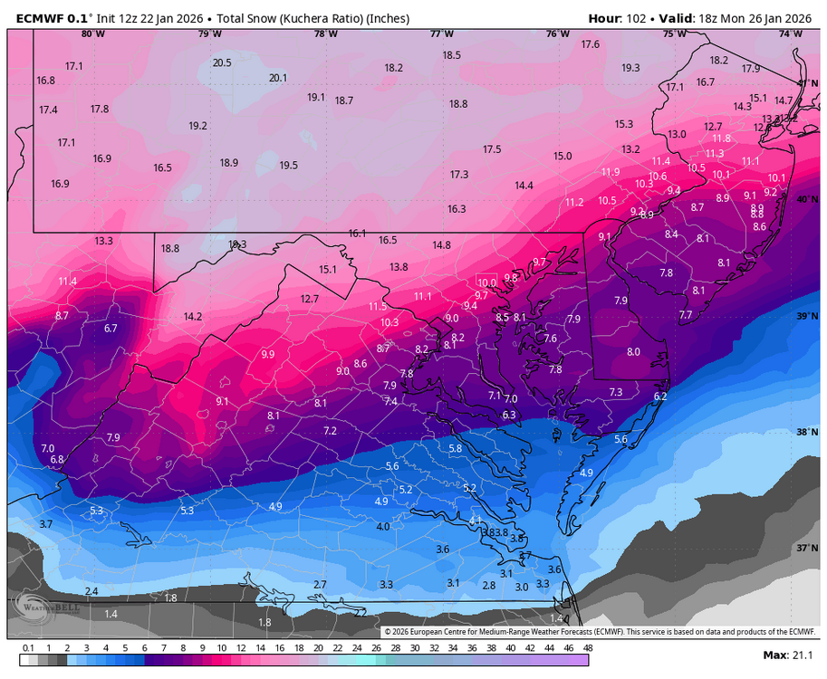
Although these maps sometimes overstate snowfall by a category, the below map illustrates just how expansive the impacts of the storm that will ultimately bring the Northeast its biggest snowfall in perhaps nearly five years will be.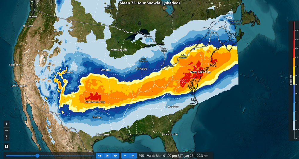
-

Possible Record Breaking Cold + Snow Sunday 1/25 - Tuesday 1/27
Franklin0529 replied to TriPol's topic in New York City Metro
You do realize the euro AI has been the #1 skilled model so far this winter correct? The euro isnt what it used to be. It folded like a cheap suit to the GFS just 5 days ago. Come on -
Actually, really, really close to these old eyes. Generally speaking, of course.
-
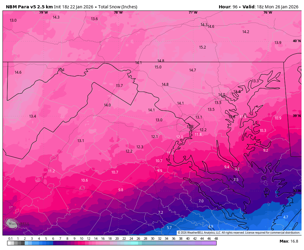
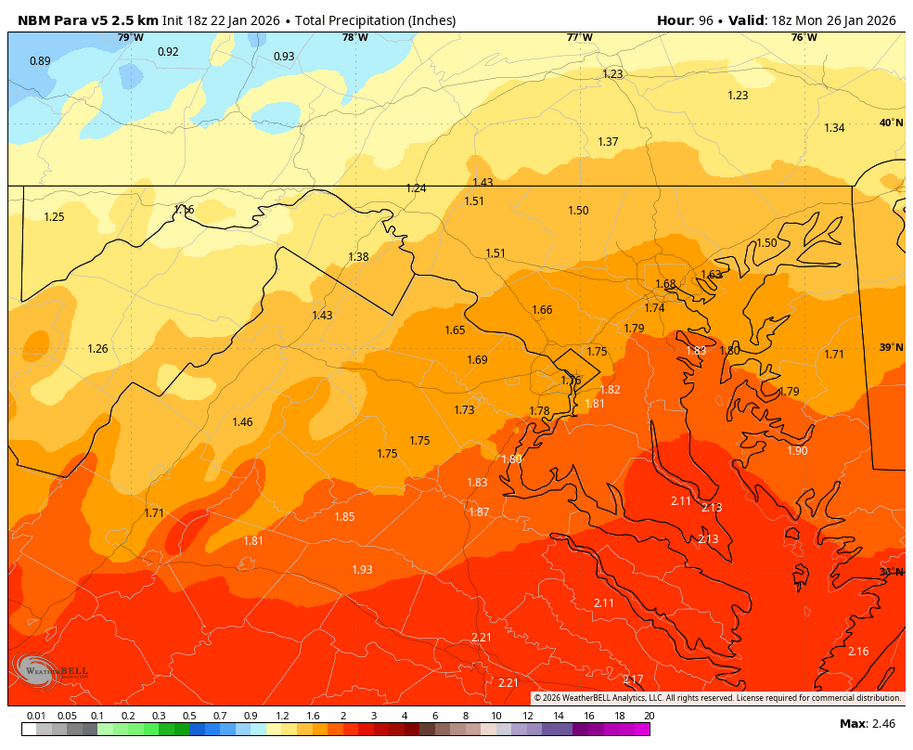
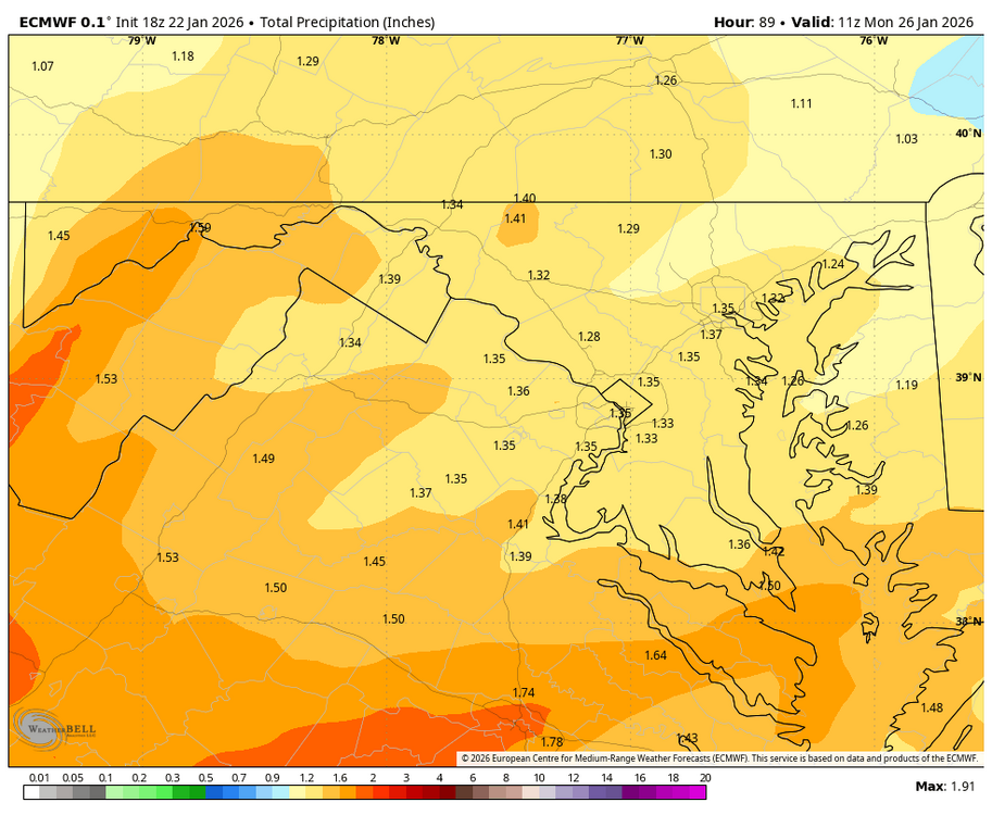
WB 21Z NBM

-
Btw NWS not backing down with their snowfall maps
-

Possible Record Breaking Cold + Snow Sunday 1/25 - Tuesday 1/27
SI Mailman replied to TriPol's topic in New York City Metro
The shop rite by me was mobbed and the shelves were empty. Ended up going to Aldi and was able to get what I needed. -

January 24-26: Miracle or Mirage JV/Banter Thread!
MDScienceTeacher replied to SnowenOutThere's topic in Mid Atlantic
Disaster -

Central PA Winter 25/26 Discussion and Obs
Superstorm replied to MAG5035's topic in Upstate New York/Pennsylvania
Wow! That would be awesome to see. . -

January 2026 regional war/obs/disco thread
George001 replied to Baroclinic Zone's topic in New England
Looks like I nailed it besides the blizzard thing (good chance the winds aren’t strong enough). Regardless, since this post the storm has trended hundreds of miles north on the models. This is going to be a burial, and I don’t think we are done. February is the snowiest month of the year for my area in terms of average monthly snowfall. If we do get a polar vortex split like @40/70 Benchmark has been talking about, March could be interesting too. -
Why am I getting crap?
-
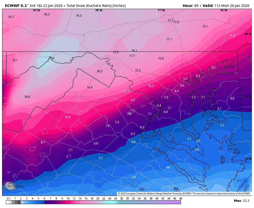
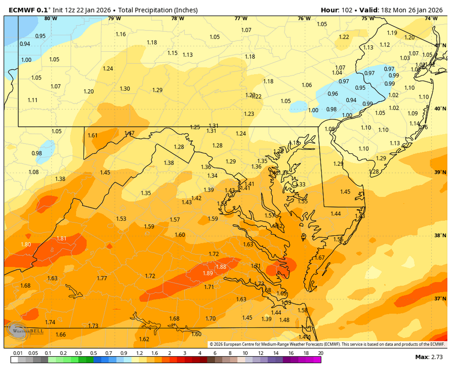
WB 18Z to 12Z EURO for comparison:


-

Central PA Winter 25/26 Discussion and Obs
canderson replied to MAG5035's topic in Upstate New York/Pennsylvania
I don’t thiiiiink so BUT my parents might get thunder freezing rain. -
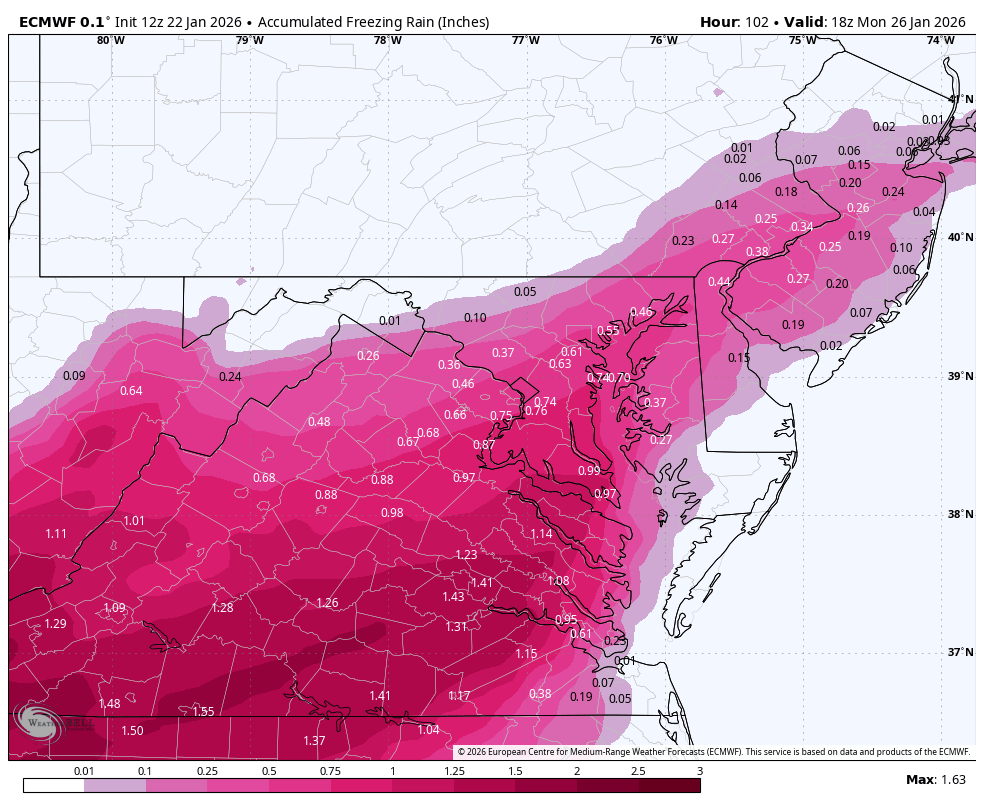
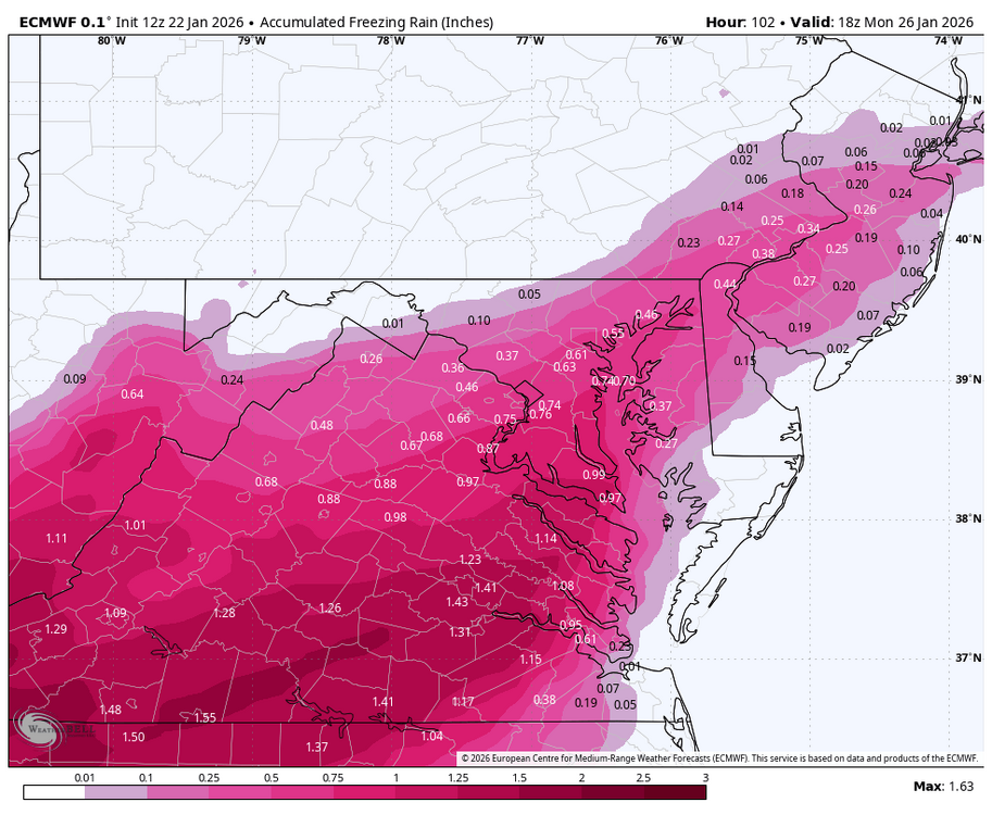
With the 20 degree F freezing rain the NWS has forecast for Saturday night, I guess the top of Mt Mitchell will be having a tropical rain.
-
1/24-1/25 Major Winter Storm - S. IL, IN, MI and OH
TheRegionRat replied to A-L-E-K's topic in Lakes/Ohio Valley
Going with 6" here. I'm wondering how that fresh snowpack will affect temperatures? I'm wondering if the forecasted lows are too high? -
Yeah I should've specified for the 2024 system. I never saw any models from it lol.