All Activity
- Past hour
-

-

2026 Mid-Atlantic Severe Storm General Discussion
George BM replied to Kmlwx's topic in Mid Atlantic
Mr. Blue Box coming out until 11pm EDT. -
https://twitter.com/tim_grooms/status/2066243886733742497?s=46&t=JYOHM881b6groqc0-RqtxA
-
Falls apart next frame
-

2026 Mid-Atlantic Severe Storm General Discussion
SnowenOutThere replied to Kmlwx's topic in Mid Atlantic
Thanks for responding/correcting me. I suppose my main take was based on assuming the storm initiation method would be the same. To my knowledge Friday and Thursday had storms due to the Lee trough and intense heating generating cape and basically hitting convective temp around 3pm. I didn’t realize today was more synoptic based for storm development. I suppose I haven’t had practice with these yet. Though, I never thought that if storms popped they wouldn’t be nasty with the increased, especially considering WxUSF mentioning we are now 2000+ CAPE. -
Anything that will have the potential to be severe needs to pop off between now and sunset. "Squall" line comes in too late. Sea breeze storm euthanasia is well inland here.
-
Brown water effect. It’s been wet in the Miss River Valley recently.
-
2026 Mid-Atlantic Severe Storm General Discussion
SnowenOutThere replied to Kmlwx's topic in Mid Atlantic
You got a link to that? Preferably the height temp dep point sheet. I still have some full page skew-T sheets I took from my lab at UVA and would love to do a hand written analysis -
I’ll always root for Big East players/teams, glad to see Brunson/Bridges/Hart win.
-
Yep. Tropical storm at landfall before regaining TS strength over OK. Hard to imagine a not even TD organizing and strengthening over land except perhaps crossing over swampland
-
Late to the party but wow, what a win! Excited for next Friday’s game…go USA!
-
2550 j/kg surface based cape on the 18z iad sounding. Seems good
- 688 replies
-
- 2
-

-
- severe
- thunderstorms
- (and 7 more)
-
Yep. Might as well head towards Pontiac to Kankakee and camp out there until the event lol.
-
It was TS Erin in 2007 over Oklahoma. I have to check but I thought Erin formed around the same spot S of TX as this to-be ghost of Erin but higher intensity over OK than the gulf.
-
I can remember some night squall lines just like that back in the 90s. .
-
92/67/100 10th 90 plus of year but not a heatwave as yesterday only got to 89. Have only 1 3 day heatwave thus far
-
.thumb.jpg.6a4895b2a43f87359e4e7d04a6fa0d14.jpg)
Central PA Summer 2026 Discussion/Obs Thread
Yardstickgozinya replied to Voyager's topic in Upstate New York/Pennsylvania
I completely agree, chances are this will be sporadic at best and that's perfectly fine. However, the one thing that all the top dogs have in common is the presence of the EML. It seems to be the main deciding factor between more of the same and a true widespread sig/svr weather when other enhanced indices are present. -
I’m trying to recall, was it Ivan that become such a beast over middle America as a hybrid low? Memory fails me. .
-
Word, ready to comma head mcs tho
-
92/64 split today... 4 day heat wave .
-
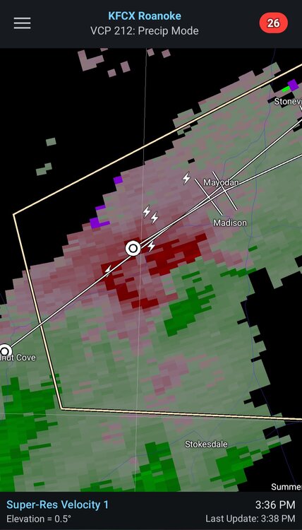
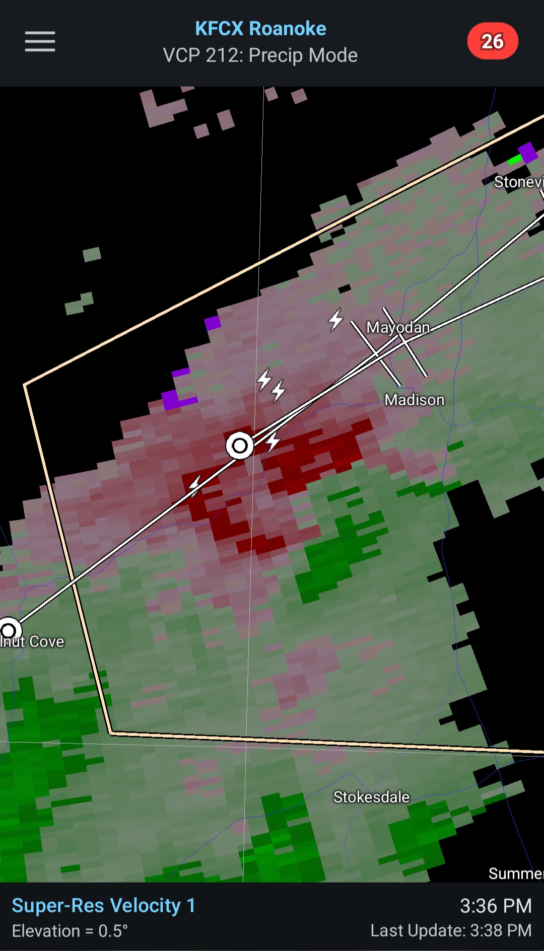
Some rotation showing between Madison and Stokesdale NC.
-
gonna go ahead and call a miss north/west here, and will hopefully be proven wrong
-

Pittsburgh PA Summer 2026 Thread
jwilson replied to TheClimateChanger's topic in Upstate New York/Pennsylvania
Severe Watch until 9 PM, but it has been pretty cloudy around here today, so I imagine that caps some of the potential. NWS did mention a possible tornado watch to come, but TBD. -
When all is said and done, Peoria to NWI gonna be the hot spot again.
-
It's been raining down your way. Looks like you're getting more today. It's been dry up here.


.thumb.jpeg.f5c6ba9d911ec96b3b124f8606aee58e.jpeg)


.thumb.jpg.a628c2147efdff1c820341d5143d9237.jpg)

.thumb.jpg.ad3a2e31d30aff035044689b311a0540.jpg)

