All Activity
- Past hour
-
Its got work to do here too
-
Nice crisp morning. Accuweather shows either 1 or 7 degrees.
-
You are the man!!! So so awesome and thanks for your hard work. This is awesome we have access to data many don't. You rock
-

Arctic Hounds Unleashed: Long Duration Late January Cold Snap
CoastalWx replied to WxWatcher007's topic in New England
Maybe tonight will get near 0. Otherwise kind of pedestrian, just prolonged. -

Possible coastal storm centered on Feb 1 2026.
Kitz Craver replied to Typhoon Tip's topic in New England
I was holding out hope for at minimum a scrape 1-3” but this could be a clean whiff for the region, possibly including the cape -

The “I bring the mojo” Jan 30-Feb 1 potential winter storm
RaleighNC replied to lilj4425's topic in Southeastern States
To paraphrase Braveheart: "My Dad says we'll get some snow out of this mess, but he's pretty sure you're $*%$ed." -

2025-2026 Fall/Winter Mountain Thread
ncjoaquin replied to Buckethead's topic in Southeastern States
Good assessment! I agree with all of this. -
You are in the sweet spot on this one. 12+ very possible
-
4 degrees
-

Arctic Hounds Unleashed: Long Duration Late January Cold Snap
HoarfrostHubb replied to WxWatcher007's topic in New England
-5F on my home thermometer, but lots of nearby Wunderground stations are -10 to -14. relentless -
Looks like everything is a go with the overnight models. This morning NAM looked wonky but the gfs looked good except for the shadow over Buncombe county but the more west the low forms the better out moisture will be from the East. The border counties have no problem at all. Forcing and moisture will be abundant. Honestly I don't think GSP is really catching that but a foot plus along the border. I'd go with a general 5 to 10 inches closer to the border and a general 4 to 8 inches away here in the mountains. Heck 4 inches is still a heck of a storm that most haven't seen in years and back to back winter weather events is awesome! Not to mention the Euro suddenly is showing something else for next Thursday.... So we are off to the races.
-

E PA/NJ/DE Winter 2025-26 Obs/Discussion
Duca892 replied to LVblizzard's topic in Philadelphia Region
GFS sticking with its 7th-9th range at the next shot it seems. Boring boring until then and frigging cold -
The 0z has temps briefly sneaking up above freezing on the 7th.
-

Richmond Metro/Hampton Roads Area Discussion
RVASnowLover replied to RIC Airport's topic in Mid Atlantic
Yeah. Let’s root that they get another potential blizzard while RIC gets edged. Sorry just frustrating -
Would you rather live through this two week long stretch of zero degree temps or read 100 pages of our Michigan posters talk about winter and snow?
-

Central PA Winter 25/26 Discussion and Obs
Voyager replied to MAG5035's topic in Upstate New York/Pennsylvania
I have very light snow falling here in Tamaqua. What the hell??? -
Possible coastal storm centered on Feb 1 2026.
CoastalWx replied to Typhoon Tip's topic in New England
Glue factory -

Possible coastal storm centered on Feb 1 2026.
Chrisrotary12 replied to Typhoon Tip's topic in New England
Too bad it’s probably real and we’re cooked. -

The “I bring the mojo” Jan 30-Feb 1 potential winter storm
olafminesaw replied to lilj4425's topic in Southeastern States
Ensembles still looking solid.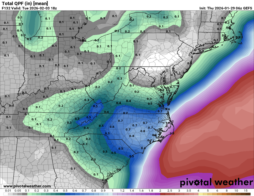
.thumb.png.645768bea6d004f1283e3c70db41d071.png)
-

2025-2026 Fall/Winter Mountain Thread
strongwxnc replied to Buckethead's topic in Southeastern States
Look at that KCLT bulls eyes on the map above. Wow. Both the GFS and EURO are solid. Hope to continue these today for sure. -
17 this morning and Winds at 5 mph. It’s chilly! Waiting for tomorrow’s forecasted snow.
-
Dulles stuck at 14. Still no mention of the blown low temp predictions in the AFD. But the "no longer an obvious coldest night" bit has been copied and pasted into every AFD for *days on end*. That's just plain lazy.
-
Possible coastal storm centered on Feb 1 2026.
Kitz Craver replied to Typhoon Tip's topic in New England
Every models has this stupid appendage/second low that forms way NE and it just chases right behind it out to sea. lost that dumbbell Fuji look from yesterday that pulled us all in. -

The “I bring the mojo” Jan 30-Feb 1 potential winter storm
SnowHabit replied to lilj4425's topic in Southeastern States
When a commenter asked about the lower totals on the WRAL map than those included in the Winter Storm Watch, WRAL’s Grant Skinner responded: ”Very good question! We decided to go more conservative with the totals since there’s still model uncertainty. Our team talked about the latest model guidance and overall pattern yesterday and early this morning. It’s not clear where a heavier band of snow will set up. It’s just a first look; we’d rather trend higher if needed than say a bunch of snow and then not have near as much.” -

Possible coastal storm centered on Feb 1 2026.
moneypitmike replied to Typhoon Tip's topic in New England
SE Mass might still score......but enjoy the cirrus everyone else. Congrats Nova Scotia.


.png.92391d43bc52466fb65efd4a9ee54be6.png)