All Activity
- Past hour
-
How about no storm thread until 72 hours out... I hate to see yall weenies crash out.
-
Another storm I felt like locked in a long time out was the big foothills crusher of Dec 18th 2009. Felt like it didn't change much and the Jan 30 2010. Man what a winter that was!
-
So out of the 10 opportunities for snow in the next 16 days how many will actually pan out?
-

First Legit Storm Potential of the Season Upon Us
Damage In Tolland replied to 40/70 Benchmark's topic in New England
Normally I’m hype and positive. I feel neither as of now . Honestly . Going into this as depressed as can be. Good luck out east -

January 2026 regional war/obs/disco thread
CoastalWx replied to Baroclinic Zone's topic in New England
Let’s not get that here since that means congrats RDU for snow -
Ah, crap. Our transmission went out on the old washer. It was more expensive to replace than it was to by a new one. We installed the new one yesterday...modeling was good today. I am not saying it is the new washer, but if we get two new washers in the forum....could be epic. Maytagmegeddon.
-
Yep that would be something. I think im going out tonight in it. @Bucketheaddid get some Thundersnow the other night.
-
The NWS is focused on the threat for Saturday with the advisories that have just been issued. Model support for the Saturday event is greater than the potential one for Sunday.
-
First Legit Storm Potential of the Season Upon Us
CoastalWx replied to 40/70 Benchmark's topic in New England
You always do this and then pull something out of your ass. -

January 2026 regional war/obs/disco thread
Torch Tiger replied to Baroclinic Zone's topic in New England
how do you plan on making that happen? -
That’s been the one I’ve been interested in
-
That Dec 2018 storm was the most relaxed I had ever been ahead of a storm. It was absolutely locked in with zero budging for a week straight and every single model was on board as well as ensembles. Our flow right now is just not slow enough to make that possible.
-
Yeah it's been some years but I remember that ice storm caused a ton off power outages and downed power lines across a large part of the region.
-
Unlink the Christmas storm in 2010. That was probably the most fun/twists of any storm I remember.
-

E PA/NJ/DE Winter 2025-26 Obs/Discussion
RedSky replied to LVblizzard's topic in Philadelphia Region
Nice run now that you brought it up, I never look at the 6z -
First Legit Storm Potential of the Season Upon Us
Damage In Tolland replied to 40/70 Benchmark's topic in New England
The writings on the wall. I started sensing it this morning and then Will just cemented it . Something about MLK and snow here. They don’t mix -
Mt. Holly has just issued a WWA for their part of northern and western NJ and NE PA for 2-4” of snow.
-

January 2026 regional war/obs/disco thread
WxWatcher007 replied to Baroclinic Zone's topic in New England
Let’s get that here. -

First Legit Storm Potential of the Season Upon Us
Supernovice replied to 40/70 Benchmark's topic in New England
Call me crazy but if this doesn’t work out and the AI models don’t verify… wouldn’t this be a point for @Typhoon Tip? Hear me out. The AI models are looking at historical data vs current at initialization and running it through (it’s not learning despite what people think), at a very basic level. So 20, 30, yrs ago- whatever, given current ingredients we would be looking at a plowable snow. But fast flow, gradient etc… it ends up weak ( that has been the theme for yrs) and east. -

Storm potential January 17th-18th
wishcast_hater replied to WeatherGeek2025's topic in New York City Metro
WWA here. I got you all beat. I never seen this before - ever. . -

Storm potential January 17th-18th
sussexcountyobs replied to WeatherGeek2025's topic in New York City Metro
Yup. I don't get why all the focus is on Sunday, when there is a more imminent threat of snow from late tonight thru Saturday? -
WWA up for orange Putnam and passaic counties for 2-4" of snow tomorrow I wonder if these will be expanded later
-

Winter 2025-26 Short Range Discussion
Snowstorms replied to SchaumburgStormer's topic in Lakes/Ohio Valley
definitely screw holed. after the main bands overnight, this band set up across the northern parts of the city for a couple hours.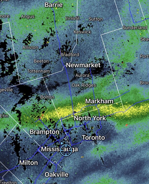
-
That and Dec 18, 2009 were pegged a week+ out. Always a few wiggles in amounts but both events locked in and stayed in modeling.
-

Southern MD / Lower Eastern Shore weather discussion
AlexD1990 replied to PrinceFrederickWx's topic in Mid Atlantic
Just to confirm/clarify, you are speaking of the Sunday(1/18) system?


