All Activity
- Past hour
-

The “I bring the mojo” Jan 30-Feb 1 potential winter storm
Regan replied to lilj4425's topic in Southeastern States
6.4in Raleigh is fine with me after the my break up with Brad. -

The “I bring the mojo” Jan 30-Feb 1 potential winter storm
NorthHillsWx replied to lilj4425's topic in Southeastern States
That’s better than it was looking. -

Central PA Winter 25/26 Discussion and Obs
sauss06 replied to MAG5035's topic in Upstate New York/Pennsylvania
I've waited 3 years to get Hockey Tickets for a game my daughter didn't have a bears game at same time. I like hockey, but her and my girlfriend are both rabid fans. Its fun listening to them, a Caps fan arguing with a Pens fan -

February 2026 Medium/ Long Range Discussion: Buckle Up!
MDSnow93 replied to Weather Will's topic in Mid Atlantic
In 10+ years of reading this forum I've never seen such low morale for seemingly no reason. We've got snow pack that's not going anywhere. We've got more cold air than I can remember seeing in a while. People are locking on to model runs 5+ days out just because it doesn't show what they want. It's pretty pathetic if I'm honest. We have smaller storms to track, and if you want a big dog, I'm no met, but in my experience those tend to come as the cold air retreats and we transition to a warmer period. Just my (worthless) 2 cents. -
The “I bring the mojo” Jan 30-Feb 1 potential winter storm
NorthHillsWx replied to lilj4425's topic in Southeastern States
This storm gonna test the sanity of triangle folks -

The “I bring the mojo” Jan 30-Feb 1 potential winter storm
eyewall replied to lilj4425's topic in Southeastern States
At this point the forecast is a crap shoot but here is the 12z Euro: -
Let's trend the Wednesday wave north. That's the easiest way to score some snow next week. Ensembles had been improving but took a step back beginning overnight. I don't think we've had a plowable snow event this winter when the ECM-AI was not showing it 6 days out.
-
-

1/30-1/31 Lake Effect Snow Threat - SE WI, NE IL, and NW IN
Chicago916 replied to A-L-E-K's topic in Lakes/Ohio Valley
Idk.. to me too much hopium. But I'm obviously rooting for the higher end outcome. -

1-30/2-1-26 Arctic Blast, ULL Snow Event
fountainguy97 replied to John1122's topic in Tennessee Valley
I think it's partly because the sun is bright right now. You can see high cirrus here but just above the mountain ridge you can see the hazy/fog layer I'm talking about.
- 659 replies
-
- 2
-

-
- extreme cold
- snow
- (and 1 more)
-
lovely Euro run. Someone near @strongwxncis getting 10+ out of this
-
The “I bring the mojo” Jan 30-Feb 1 potential winter storm
NorthHillsWx replied to lilj4425's topic in Southeastern States
EURO not great for triangle… EDIT: gets better -

1-30/2-1-26 Arctic Blast, ULL Snow Event
BlunderStorm replied to John1122's topic in Tennessee Valley
It started off milky here. The first flakes fell from a pale blue sky. I haven't seen defined clouds today haha. Granted it was just after dawn. -
-

Richmond Metro/Hampton Roads Area Discussion
overcautionisbad replied to RIC Airport's topic in Mid Atlantic
What would be the most reliable short range model to use now? Btw your 12z Euro.thumb.png.17aadd1945f34a8288be2ccdb501c500.png)
-

1-30/2-1-26 Arctic Blast, ULL Snow Event
Daniel Boone replied to John1122's topic in Tennessee Valley
Cloud layer has thinned; still solid stratiform but transparent enough the Sun is coming through pretty good. A few small flakes still falling but nothing like it started. Current Temperature is up to 28. Jumped 2 degrees last 45 Minutes. -
despite the chilly temps, sun angle really doing a number on the pack. Wow
-

February 2026 Medium/ Long Range Discussion: Buckle Up!
Cobalt replied to Weather Will's topic in Mid Atlantic
a bit IMBY-centric but it did juice up compared to 6z. 50 miles North or so? vs 6z Doesn't end up meaning much for DC-North but it did go further South which at least opens up future possibilities. Very early in the game.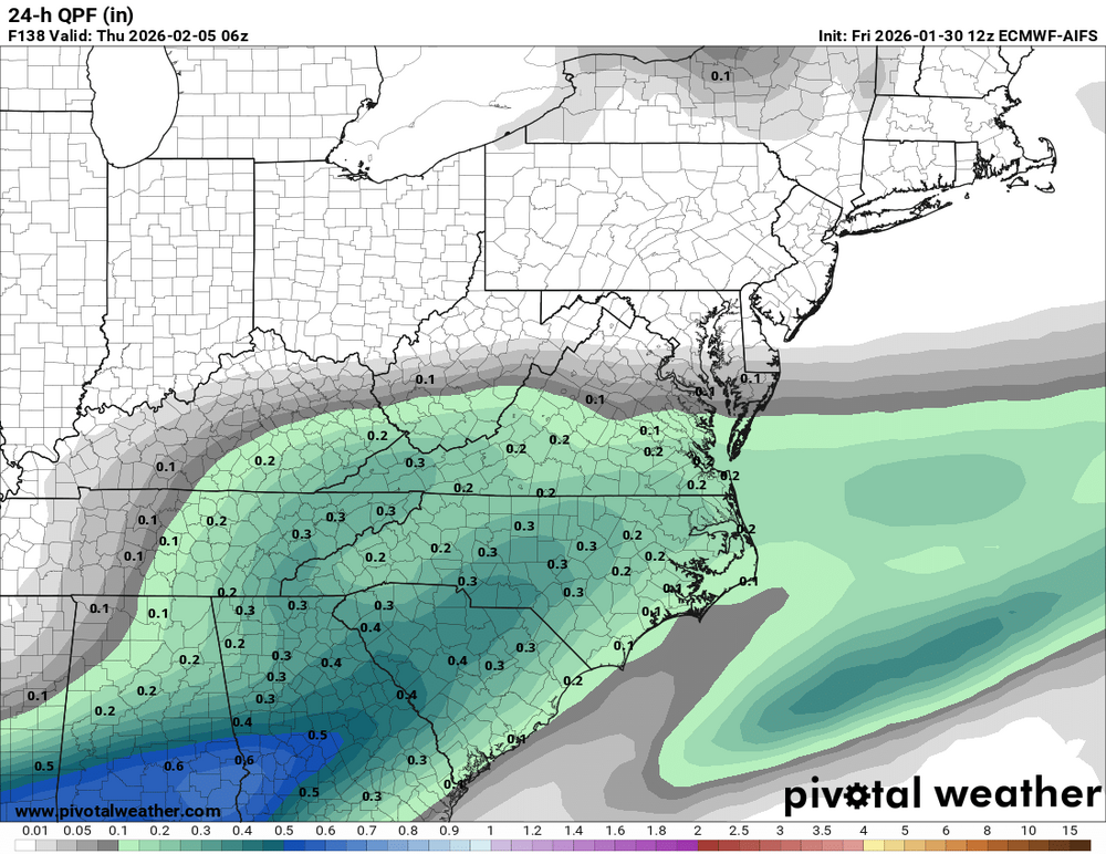

-

The “I bring the mojo” Jan 30-Feb 1 potential winter storm
CaryWx replied to lilj4425's topic in Southeastern States
Following weather models is a 'what have you done for me lately' exercise -

February 2026 Medium/ Long Range Discussion: Buckle Up!
TSSN+ replied to Weather Will's topic in Mid Atlantic
It’s ok the clipper at 264 will save us! Till it ends up over Atlanta. lol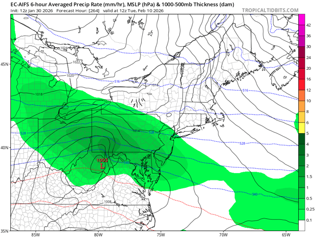
-
1-30/2-1-26 Arctic Blast, ULL Snow Event
fountainguy97 replied to John1122's topic in Tennessee Valley
I might be going crazy but the returns on radar are strange. Off in the distance here I don't really see many clouds but it's more of a fog. Just a weird observation. Complete blue sky here with the sun out with a white fog off in the distance.- 659 replies
-
- 2
-
-
- extreme cold
- snow
- (and 1 more)
-

1/30-1/31 Lake Effect Snow Threat - SE WI, NE IL, and NW IN
Chicago Storm replied to A-L-E-K's topic in Lakes/Ohio Valley
The headlines in place have high “bust” potential. The WWA will likely “bust” for most areas with the round this morning/afternoon just due to the fact that the higher accumulations will be very localized. For the round between this evening through tomorrow evening, it’s very clear that the best accumulations will be from Downtown/Eastern Cook County on east into northwest Indiana. So, due to how headlines have to be issued, most of the warning will “bust” for much of Cook County. -

Possible coastal storm centered on Feb 1 2026.
Damage In Tolland replied to Typhoon Tip's topic in New England
https://x.com/bigjoebastardi/status/2017268971561500751?s=46&t=dhcbvkjmRcyBVQtDxJ3lRg -

February 2026 Medium/ Long Range Discussion: Buckle Up!
North Balti Zen replied to Weather Will's topic in Mid Atlantic
bouncing around the back of the car like it is the 1970s... -

February 2026 Medium/ Long Range Discussion: Buckle Up!
NorthArlington101 replied to Weather Will's topic in Mid Atlantic
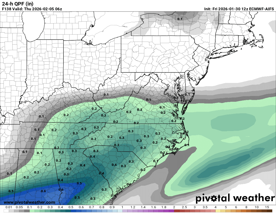
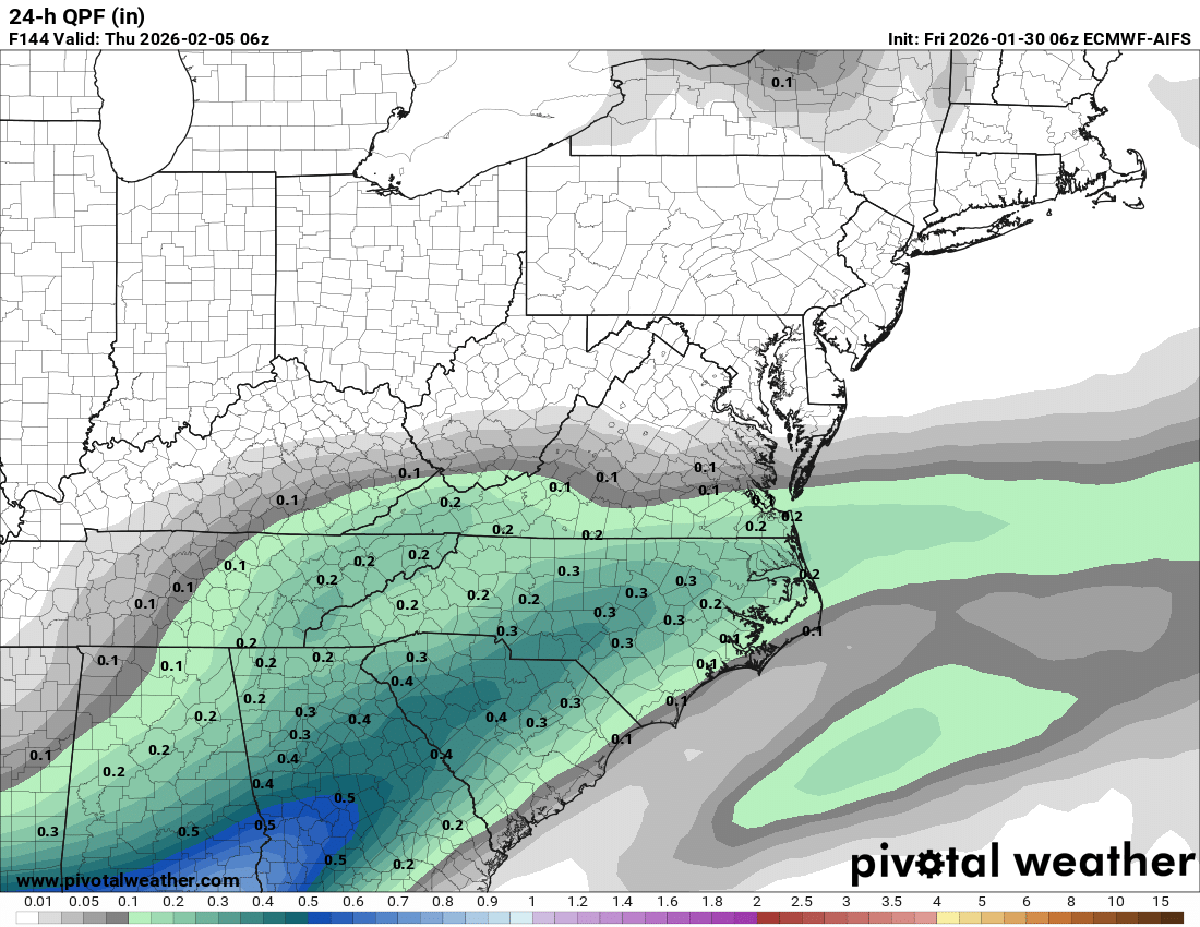
Juiced up a little bit, yeah. Still fairly fringed. Belongs in the other thread really but AIFS ticked better for our southern folks for Saturday. Somewhat decent tick given its usual stubbornness in the last few hours. Might mean an extra inch for someone. But if you buy it verbatim really only a super cool storm for eastern NC/barrier islands at this point.


.png.37d6fcf4283fb3e4858a9da2fb00a432.png)