All Activity
- Past hour
-
Yeah, it's too disturbingly unpleasant for a profile photo. Could give the kids nightmares. (If you want a nightmare, just go back and read through one of our winter storm threads.)
-
Of course it rained here a bit this AM., when probs were low, now I can't the lawn. Lets see if the flood watch delivers for later. Mount Holly states the highest threat for severe is South of Philly. Large area of cloud cover at this time.
-

Central PA Summer 2026 Discussion/Obs Thread
Jns2183 replied to Voyager's topic in Upstate New York/Pennsylvania
Pure swamp ass outside Sent from my SM-S731U using Tapatalk -
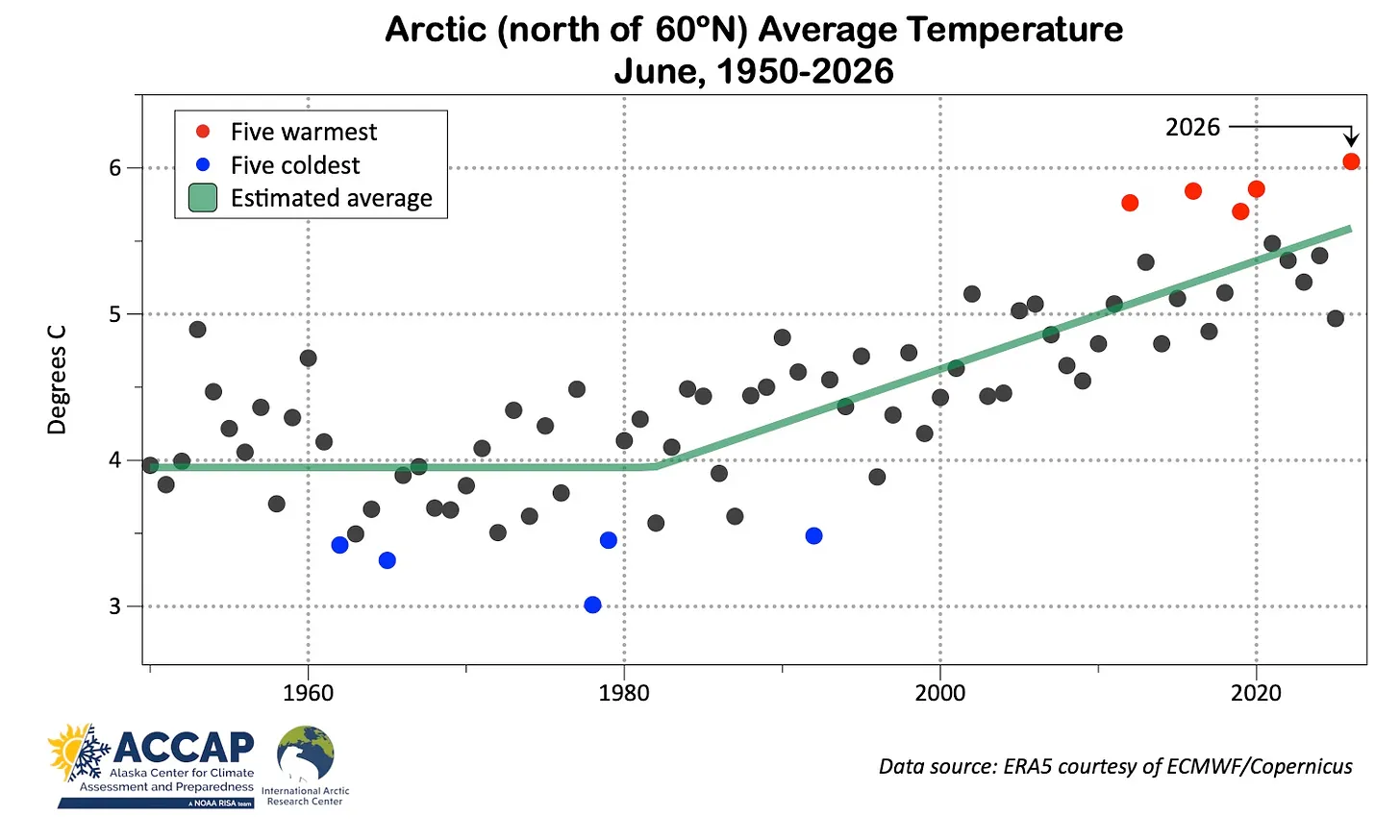
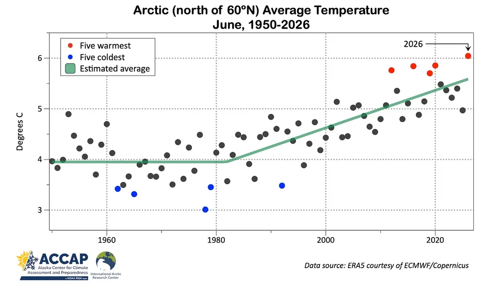
Even though the areas north of 60N had their warmest June on record, a small area of the Arctic to the north of Alaska had their coldest June on record. This Beaufort Sea region is a key area in determining what the annual sea ice minimum in September will be. Early season weak dipole patterns which are colder in this region have been common since 2013. It indicates locally fewer melt ponds and a better pattern for sea ice retention toward the Pacific side of the Arctic. Seasons like 2012 and 2020 had very strong dipole patterns which preconditioned the ice for a big melt out by August and September. Most seasons since 2013 have finished in the 4.0 to 4.9 million sq km range for extent. Only 2012 and 2020 finished below 4.0 million sq km due to extreme dipole patterns and early record melt ponding. Climatologist49 @climatologist49.bsky.social Follow For the combined area poleward of 60N, this was the warmest June on record - despite the fact that a portion of the area north of Alaska had its coldest June on record (since 1940). @alaskawx.bsky.social 10:51 PM · Jul 6, 2026 Arctic Temperatures https://alaskaclimate.substack.com/p/june-2026-arctic-and-alaska-climate June was very mild over a large part of the Arctic. About 70 percent of the Arctic (land and seas poleward of 60°N) had a warmer than average June relative to the 1991-2020 baseline (Fig. 1). But almost 85 percent of Arctic land areas were milder than normal. About 12 percent of the Arctic had the warmest June since 1950 in ERA5 reanalysis, while only 1 percent had the coldest June in the past 77 years. The warmth was most dramatic in western Siberia. For Yamalo-Nenets Autonomous Okrug this was by far the warmest June on record. For the third time in the past five years, Svalbard had the warmest June on record. Parts of the Northwest Territories and southern Nunavut, Canada also had the warmest June on record. Areas with below normal temperatures were more restricted. June was quite chilly north of about 75N over the Canadian Arctic Islands and westward into the Arctic basin east of the dateline as well as on Alaska’s North Slope. Of special note was the extreme warmth in northwest Siberia on June 25. Beliy Island (73.3°N), just offshore of the Yamal Peninsula, reached 28.3C (83F). According to M. Herrera on his “Extreme Temperatures Around the World” Bluesky account, this is (apparently) the highest temperature on record so far north anywhere in the world. This heat was concurrent with the late June western and central European heatwave but was entirely distinct, as Russia east of Ural Mountains was generally cooler than normal during this time. Since 1950, this was easily the warmest June on record for the Arctic overall (Fig. 2) and the mildest since 2020. Arctic lands also had the highest June average temperature.
-
 I guess they are relying on the "in or around" aspect to capture and inform the risk ... lol Synoptic parameterization throughout the day today do not appreciably differentiate eastern interior MA, nor S. ME, from that region. But, I have not read their AFD; I may be missing something
 -
Managed to get another 0.07 bringing July total to about 0.23". Many rain days, but little rain.
-
2026-2027 Super El Nino
Typhoon Tip replied to Stormchaserchuck1's topic in Weather Forecasting and Discussion
this illustration there is annoying... the arrow of the circulation eddy is pointed up demonstratively where they write "down" welling -
And only east if you are north or south This looks very familiar.
-
Not much value in a 35-60" range, which is why you shouldn't bother to issue a seasonal snowfall map in July.
-

Weather Station
40/70 Benchmark replied to Storm Clouds's topic in Weather Forecasting and Discussion
I had a Davis VP 2 years ago, as well.....agree that the maintenance is cumbersome and the data interface is not very user-friendly. Ambient is a nice alternative....not a huge step down in terms of accuracy and much less of a PIA. I've had it for about 7-8 years. -
And south and north too.
-
Central PA Summer 2026 Discussion/Obs Thread
Jns2183 replied to Voyager's topic in Upstate New York/Pennsylvania
I'm hoping we can get some steady rain. These fast downpours suck due to run off which does nothing to recharge groundwater Sent from my SM-S731U using Tapatalk -

Central PA Summer 2026 Discussion/Obs Thread
Mount Joy Snowman replied to Voyager's topic in Upstate New York/Pennsylvania
Low of 71 with a rounded-up .01” of rain from a brief early morning mini shower. Late this afternoon could get very interesting around here. -
Central PA Summer 2026 Discussion/Obs Thread
Jns2183 replied to Voyager's topic in Upstate New York/Pennsylvania
They all are going to be like that today. The AFD kept hammering how efficient the warm rain process will be today with tall skinny cape and warm clouds up to 11k ft. A little blob is going to put down a whole lot of rain. Someone is going to see 2"-5" today. Sent from my SM-S731U using Tapatalk - Today
-
Records: Highs: EWR: 104 (1993) NYC: 106 (1936) LGA: 98 (1993) JFK: 101 (1993) Lows: EWR: 56 (1963) NYC: 54 (1963) NYC: 57 (1963) JFK: 55 (1963) Historical: 1860 - A hot blast of air in the middle of a sweltering summer pushed the mercury up to 115 degrees at Fort Scott and Lawrence, KS. (David Ludlum) 1876: The minimum temperature of 80° or above on the 9th and 10th were the warmest two consecutive nights ever in Washington, DC.(Ref. Washington Weather Records - KDCA) 1882 - Ice formed on the streets of Cheyenne, WY, during a rare summer freeze. (David Ludlum) 1936 - The temperature hit an all-time record high of 106 degrees at the Central Park Observatory in New York City, a record which lasted until LaGuardia Airport hit 107 degrees on July 3rd in 1966. (The Weather Channel) 1938: A deadly, estimated F4 tornado moved east-southeast across the eastern edge of Andover, SD to north of Bristol, SD. 17 buildings were destroyed at Andover, and at least one home was completely swept away. An elderly person was killed at the western edge of Andover and a couple died in a home at the southern edge of town. About two hours later, another estimated F4 tornado moved east-northeast from two miles northeast of White, South Dakota in Brookings County to Hendricks, MN. (Ref. Wilson Wx. History) 1968 - Columbus, MS received 15.68 inches of rain in 24 hours to establish a record for the state. (The Weather Channel) 1979: Hurricane Bob was born in the Gulf of Mexico, becoming the first Atlantic Hurricane to be given a male name. 1982: Wind shear caused the crash of Pam Am flight 759 after takeoff from New Orleans International Airport in Louisiana. 145 people on the plane and 8 people on the ground were killed. (Ref. Wilson Wx. History) 1987 - Thunderstorms produced severe weather in Michigan. A tornado near Munising, MI, destroyed part of a commercial dog kennel, and one of the missing dogs was later found unharmed in a tree top half a mile away. (The National Weather Summary) (Storm Data) 1988 - Twenty-three cities in the eastern U.S. reported record high temperatures for the date. Alpena, MI, and Buffalo, NY, suffered through their sixth straight day of record heat. The percentage of total area in the country in the grips of severe to extreme drought reached 43 percent, the fourth highest total of record. The record of 61 percent occurred during the summer of 1934. (The National Weather Summary) 1989 - Morning thunderstorms produced very heavy rain in southern Lower Michigan and northern Indiana. Up to 5.6 inches of rain was reported in Berrien County, MI. Sioux Falls SD reported a record high of 108 degrees. (The National Weather Summary) (Storm Data) 1992: Severe thunderstorms produced a swath of very large and damaging hail and damaging winds. Golf ball-size hail and 60 mph winds were reported on the west side of Decatur, IL with numerous roofs and automobiles damaged by the hail. Hail grew to nearly the size of baseballs by the time the storms reached the Charleston/Mattoon areas. Total damage from the storms was estimated around $5 million dollars. (Ref. Wilson Wx. History) 1993: One of the strongest and most long-lived wind events of recorded history in the Midwest pounded portions of Nebraska and Iowa. The wind event, called a Derecho, actually started near Goodland, KS and raced across southern Nebraska and into Iowa traveling at 60 mph. In the Omaha metro area, tree and property damage was heavy as 70 to 100 mph winds caused $7 million dollars in damage. Also in Nebraska, power line damage alone totaled $30 million dollars and total property damage was estimated near $100 million dollars. This wind storm even spawned a tornado in the city of Lincoln, NE causing damage to the north end of town. As the derecho moved into southwest Iowa, 13 high-tension power line poles were downed on the east side of Council Bluffs. Winds continued in the 85 mph range as far as east as Fremont County, Iowa before finally subsiding in the central part of the Hawkeye State. 11 inches of rain fell overnight in Scranton, IA. Much of the downtown of Davenport, IA was under water as the Great Flood of 1993 raged on. 1993" record daily high temperatures were set at: Newark, NJ: 104°, NYC-Kennedy Airport, NY: 101°, Greensboro, NC: 101°, Atlantic City, NY: 100°, Wallops Island, VA: 100°, Dulles Airport, VA: 99°, NYC-LaGuardia, NY: 98°, Concord, NH: 95° and Islip, NY: 93°. (Ref. Wilson Wx. History) 2003: A new July maximum temperature record was set as Anchorage, AK hit 84°. (Ref. Wilson Wx. History)
-
76 / 68 partly - mostly cloudy with some showers and storms isolated into E PA and southern areas. In / out of the clouds - warm mid 80s with some scattered storms in the pm and evening. Similar but warmer Friday and with enough clearing, 90 i the hottest locals. The weekend looks mainly dry but still some isolated storms possible Sat. The western ridge is building the the NE trough lifts out - heat pushes east towards the 14th and beyond with overall warm - hot in the period, and next shot at widespread strong (95+) heat 7/14 - 7/16.
-
2026-2027 Super El Nino
40/70 Benchmark replied to Stormchaserchuck1's topic in Weather Forecasting and Discussion
Def. agree with raindance on volatility....probably going to be a potpourri of east-based, Modoki and MC forcing, with less emphasis on that latter relative to the past decade. -
2026-2027 Super El Nino
40/70 Benchmark replied to Stormchaserchuck1's topic in Weather Forecasting and Discussion
Probably a better shot than most of the past decade to be perfectly honest...it's been dry as hell. -
 ...I have neighbors who have been in their pool countless times during thunderstorms...some people are lucky ..if I did that I'd be fried like bacon at a fast food place..
 -

Central PA Summer 2026 Discussion/Obs Thread
Blizzard of 93 replied to Voyager's topic in Upstate New York/Pennsylvania
This morning shower was an over performer in Marysville with .60 of rain already today. -

2026-2027 Super El Nino
snowman19 replied to Stormchaserchuck1's topic in Weather Forecasting and Discussion
The models continue to show the WPAC, CPAC and EPAC waking up with TC’s. This is only going to keep the WWB train going and going…. -
 He’s just sittin and smilin looking at qpf charts thru day 14
 -
 Webbed hands hanging onto us.
 -
I read that article yesterday. I do agree that it is a worthwhile read. Within the last month I read the following 2 articles: both are worthwhile reads . https://fortune.com/article/gen-z-college-students-struggling-to-read-books-professors-forced-to-rethink-standards-warn-of-anxiety-lack-of-workplace-prepardness/ https://futurism.com/future-society/college-students-losing-ability-read It is very difficult to obtain an education without being able to read and to comprehend what is read. People who arent around kids don't realize how bad of an education many kids are receiving....and that includes many parents. At many schools the daily goal is " Let's not do anything that gets us on the 6 o'clock news"....serious issues are being swept under the rug.
-
people felt a 2.9?!