All Activity
- Past hour
-
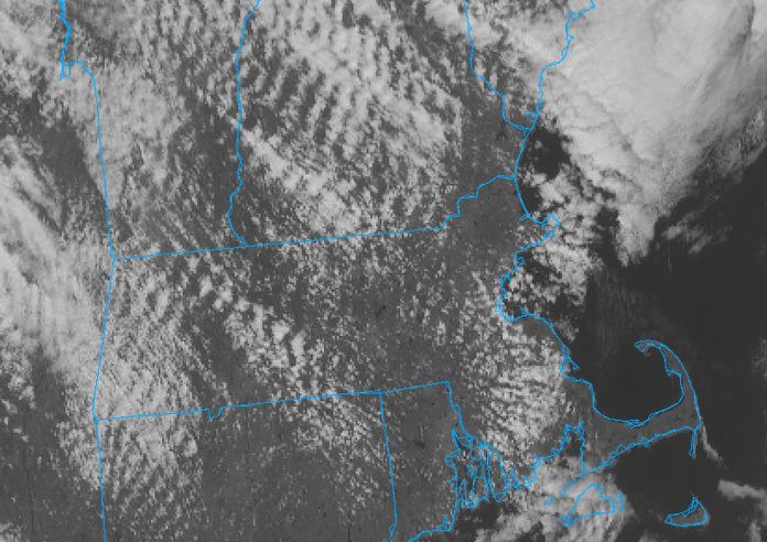
I have a small bit of Aspergers for shit like this ...whereby I remember things that are utterly useless haha... But it serves me once in while to see or sense patterns? I sense that you are probably located in a bad geographic circumstance in relation to elevation forcing - because every time you complain in that sort of same vein, it's a similar issue; this image looped shows that's actually trying to clear everywhere but those standing wave patterns are killing you
-
DTW is overcast and 35° at noon. What a way to run a nationwide torch day
-
Some models have an inv trough look on Monday in ern areas with decent instability 700 and below. Maybe a burst that coats the ground into the evening?
-
The middle post was sarcasm ofc ;p. Decent day
-
-
AWT. Some knew.
-
53-55F here gorgeous out
-
Don’t feel as good about Sunday-Monday as I did about Friday’s system. Looks pretty weak now.
-
48F and partly cloudy. Can't complain.
-
Absolute shit day. Overcast and haven't had a peek of sun yet. 34.7F
-
because you fucked around with the data to make it look that way
-
Time for Kev to check out of S Wey
-
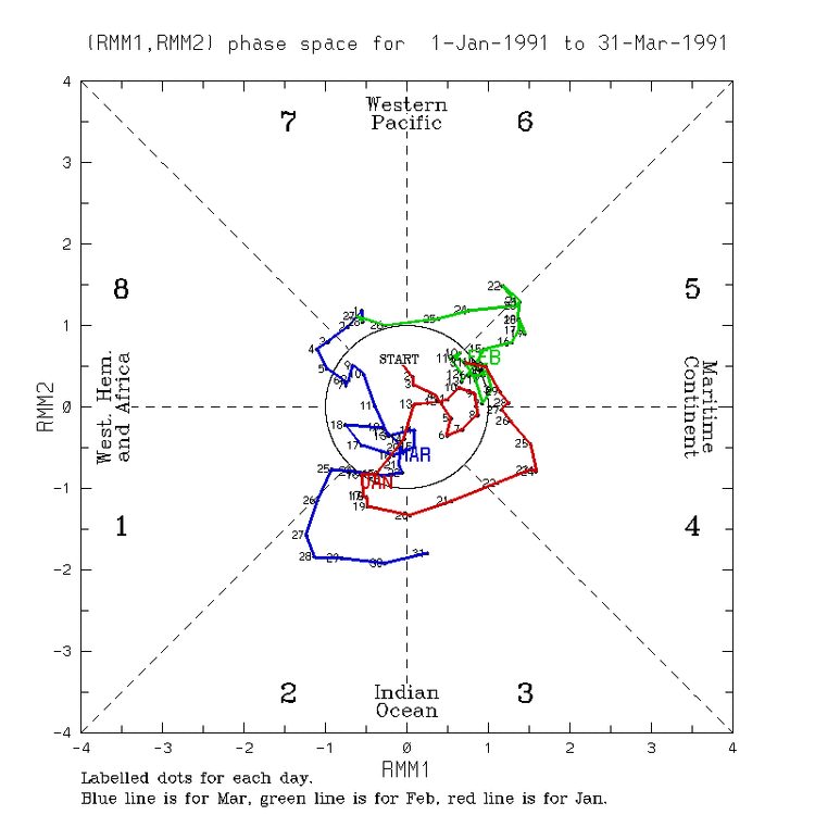
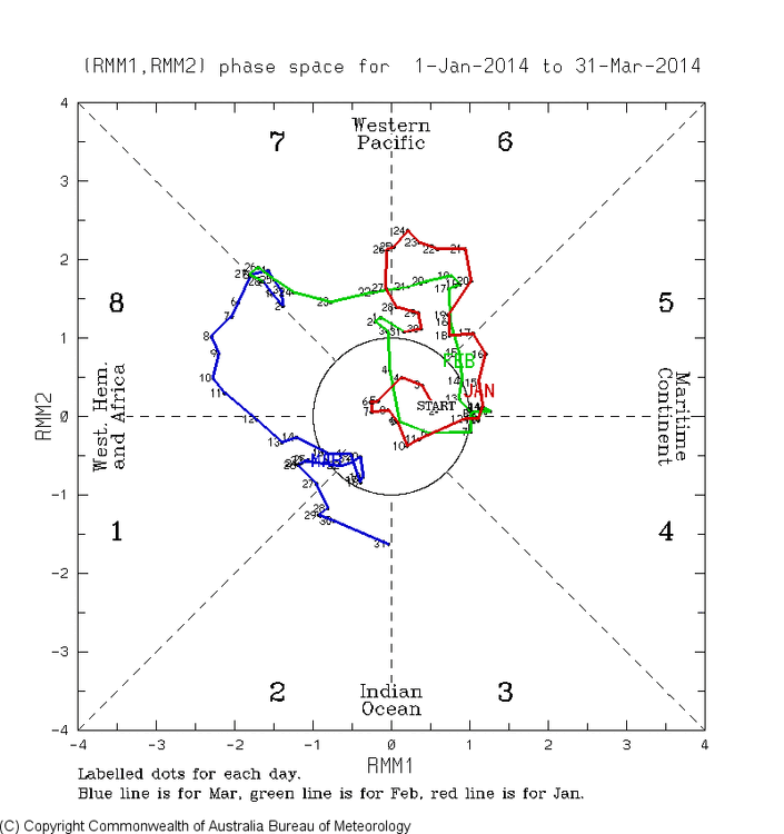
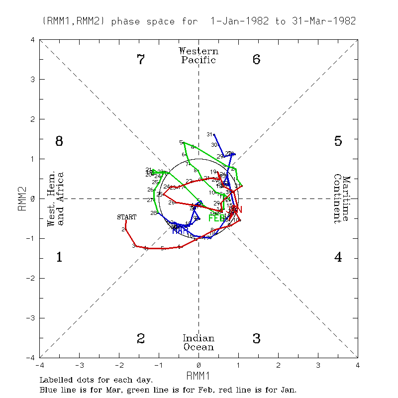
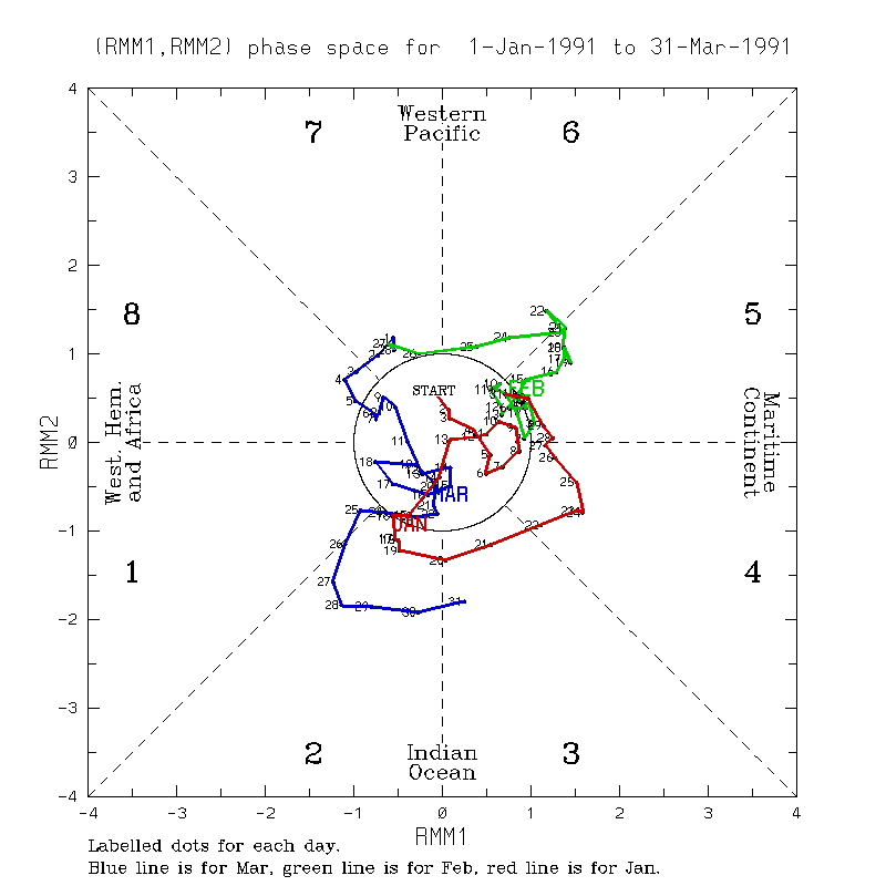
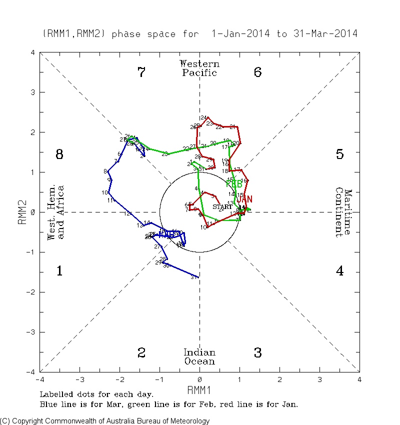
Interesting because 2015 and 1997 had similar strong 7/8 in March to 23. OTOH, the strong to super Ninos of 1982 and 1991 didn’t while the weak 2014 did: 2014 had strong 7/8 but ended up very weak Nino:

- Today
-

2026-2027 El Nino
roardog replied to Stormchaserchuck1's topic in Weather Forecasting and Discussion
Thanks for providing great information as to why a super Nino isn’t a slam dunk like twitter believes it to be. -
(002).thumb.png.6e3d9d46bca5fe41aab7a74871dd8af8.png)
Central PA Spring 2026 Discussion/Obs Thread
ChescoWx replied to Voyager's topic in Upstate New York/Pennsylvania
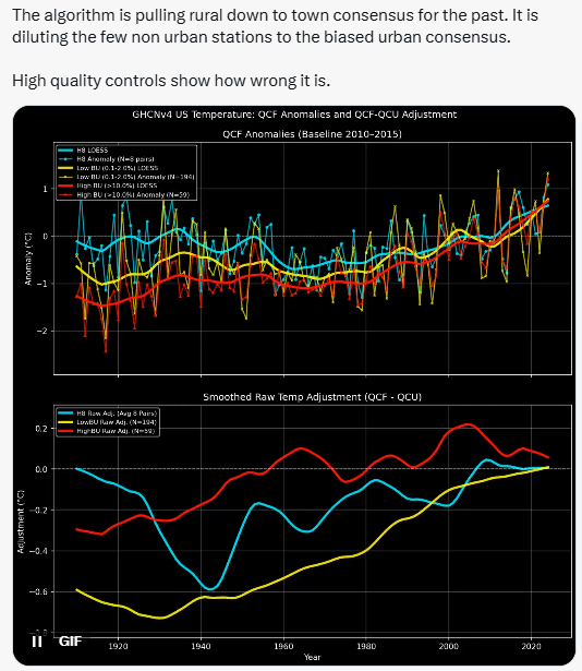
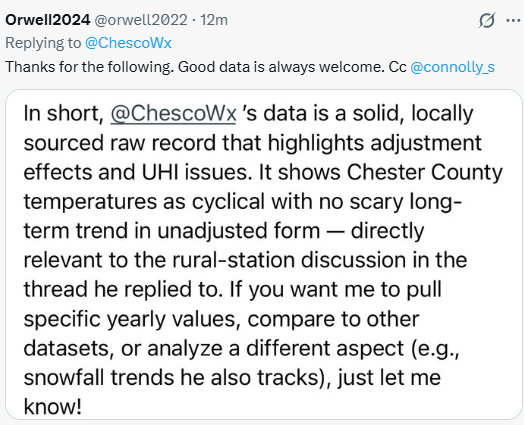
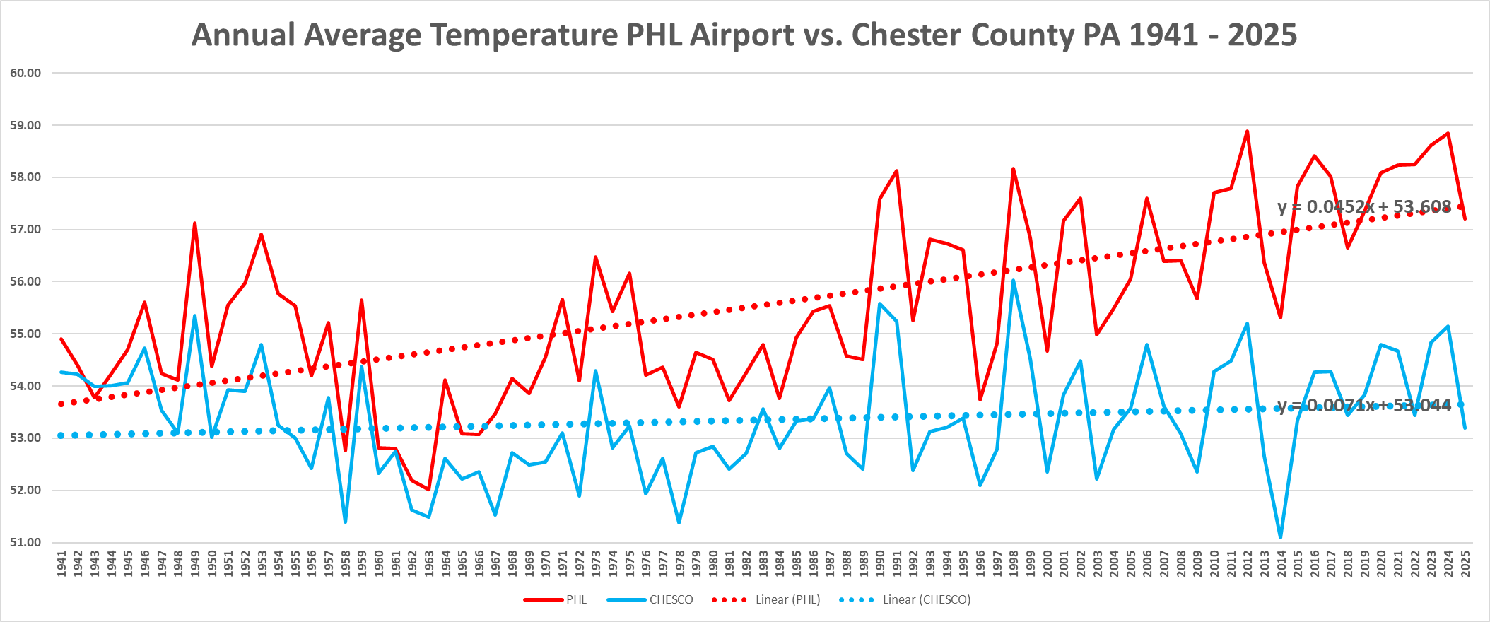
Updated annual average temperatures for suburban Chester County PA vs the PHL Airport....UHI FTW! -
Found this little sapling growing under my deck. I am guessing its eastern red cedar? Can any of you tree guys confirm? Think I am going to try and move it out into the yard somewhere if it is.

-
E PA/NJ/DE Spring 2026 Obs/Discussion
ChescoWx replied to PhiEaglesfan712's topic in Philadelphia Region
Updated annual average temperatures for suburban Chester County PA vs the PHL Airport....UHI FTW! In fact in analyzing the warming slope - PHL is now warming at a 6x faster rate than the Philly burbs!
-
Updated through 2025 - who knows why PHL is warming so much faster than non-UHI spots at airports?? In fact the PHL warming slope is now growing at 6 times the rate of Chester County Pa!

-
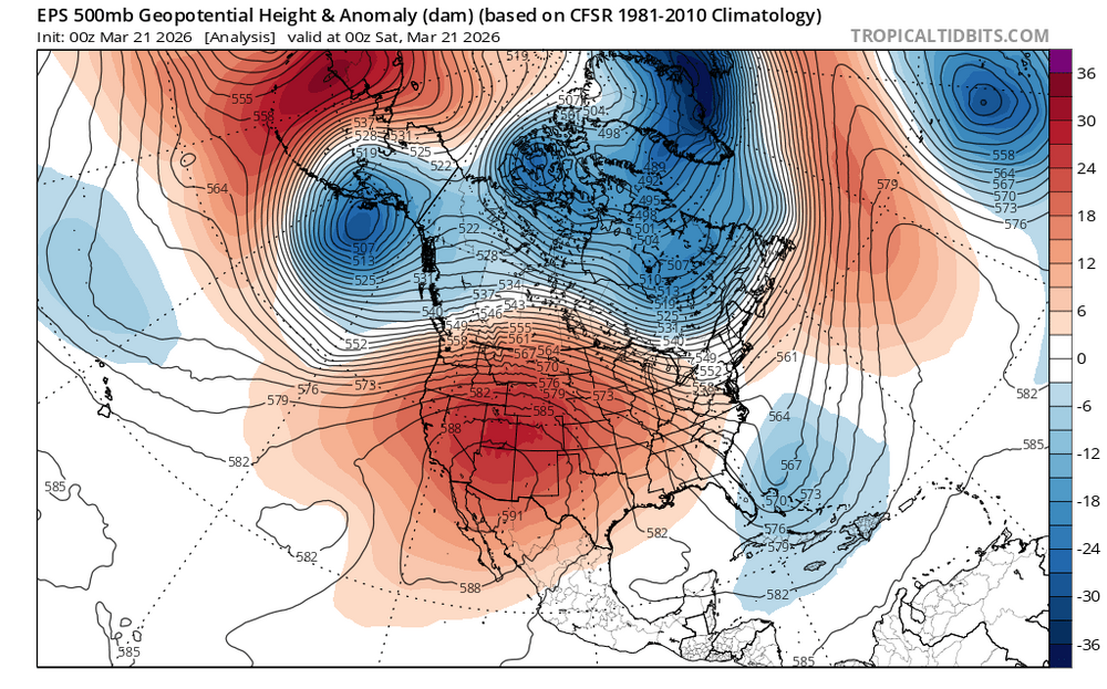
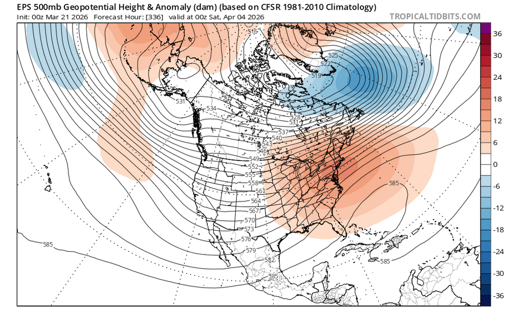
let's get one of those beastly western ridges to flex up this way
-
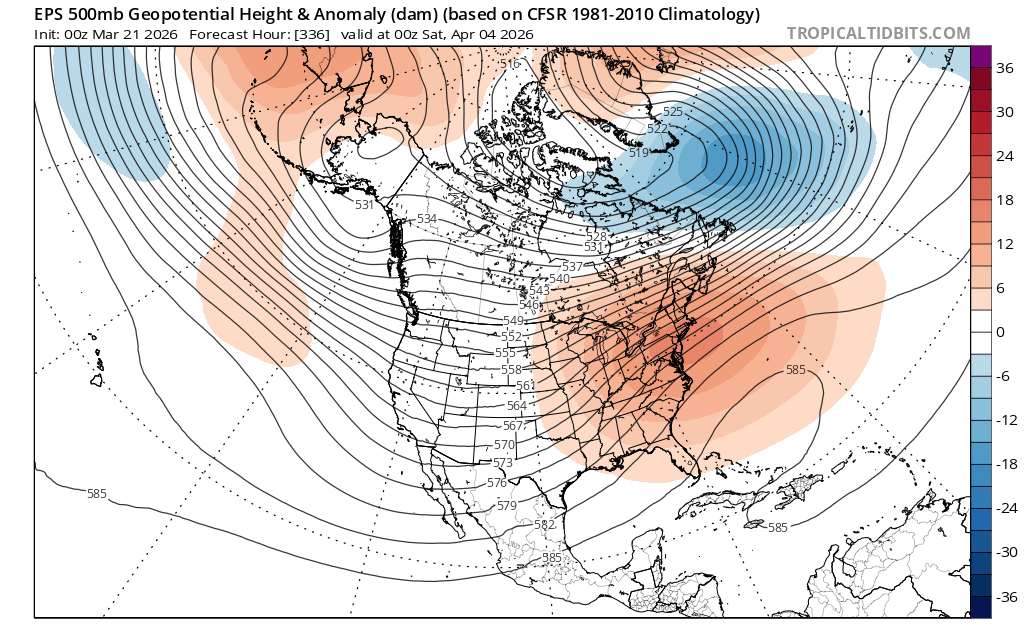
0z Euro still showing the noticable changes we talked about a few days ago.
-

2026-2027 El Nino
so_whats_happening replied to Stormchaserchuck1's topic in Weather Forecasting and Discussion
The strength of the of westerlies will fluctuate over the next week but it is more so the actual motion and presence that are the more important factors, showing things have at least started to change. As of now it looks like the MJO and the westerlies are not in tandem, MJO seems to be front running but if MJO slows or westerlies speed up they will be much more connected which could mean we have finally reached the point where things really start to get going with the Nino event. Time will tell -
Chilling our past will always helps support climate alarmism....
-
Yup, good until Labor Day.
-

2026 Mid-Atlantic Severe Storm General Discussion
high risk replied to Kmlwx's topic in Mid Atlantic
Definitely can! I think that the timing isn't good for most of us, although there appears to be a signal for some earlier storms dropping southeast into northeastern MD. -
March 21 1953: A tornado hits the northern St. Cloud area. High winds from thunderstorms are experienced from Martin to Stearns County. For Saturday, March 21, 2026 1932 - A tornado swarm occurred in the Deep South. Between late afternoon and early the next morning severe thunderstorms spawned 31 tornadoes in Alabama, Mississippi, Georgia and Tennessee. The tornadoes killed 334 persons and injured 1784 others. Northern Alabama was hardest hit. Tornadoes in Alabama killed 286 persons and caused five million dollars damage. (David Ludlum) 1952 - Severe thunderstorms spawned thirty-one tornadoes across Arkansas, Tennessee, Missouri, Mississippi, Alabama and Kentucky. The tornadoes killed 343 persons and caused 15 million dollars damage. Arkansas and Tennessee each reported thirteen tornadoes. The towns of Judsonia AR and Henderson TN were nearly wiped off the map in what proved to be the worst tornado outbreak of record for Arkansas. A tornado, one and a half miles wide at times, left a church the only undamaged building at Judsonia. (David Ludlum) (The Weather Channel) 1987 - A winter storm in the Northern High Plains Region produced blizzard conditions in western South Dakota. Winds gusted to 70 mph at Rapid City SD, and snowfall totals ranged up to 20 inches at Lead SD. The high winds produced snow drifts six feet high. (The National Weather Summary) (Storm Data) 1988 - Bitterly cold weather prevailed across the northeastern U.S. Portland ME reported their coldest spring day of record with a morning low of 5 above, and an afternoon high of just 21 degrees. Marquette MI reported a record low of 15 degrees below zero. (The National Weather Summary) (The Weather Channel) 1989 - Snow blanketed the northeastern U.S. early in the day, with six inches reported at Rutland VT. Morning and afternoon thunderstorms produced large hail and damaging winds from southwestern Mississippi to southwest Georgia. (The National Weather Summary) (Storm Data) 1990 - The first full day of spring was a cold one for the eastern U.S. Freezing temperatures damaged 62 percent of the peach crop in upstate South Carolina, and 72 percent of the peach crop in the ridge area of South Carolina. Elkins WV, which a week earlier reported a record high of 82 degrees, was the cold spot in the nation with a morning low of 16 degrees. (Storm Data) (The National Weather Summary)


.thumb.png.4150b06c63a21f61052e47a612bf1818.png)