All Activity
- Past hour
-

Pittsburgh/Western PA WINTER ‘25/‘26
ChalkHillSnowNut replied to Burghblizz's topic in Upstate New York/Pennsylvania
I’m under a WWA for 2-6 from 1pm today-1pm tomorrow….. -
The schtick from the same actors is tiresome. I know I've contributed to that discourse in the past, but I've tried to stop it as best I can.
-

Ice Ice Baby December 28-29 Storm Discussion
AstronomyEnjoyer replied to Baroclinic Zone's topic in New England
Dumping rain at 32.0°. Lovely.
-
How’s 2026/27 looking?
-
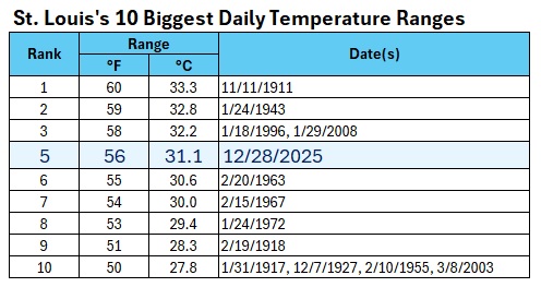
St. Louis had its fifth biggest daily temperature range on record yesterday, as the mercury plunged from a December monthly record 78F (25.6C) to 22F (-5.6C). That was the largest daily temperature range on record for December.
-

Pittsburgh/Western PA WINTER ‘25/‘26
colonel717 replied to Burghblizz's topic in Upstate New York/Pennsylvania
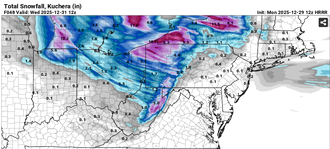
Looks like someone can pick up anywhere from an inch to 4 if they get in the right bands over next 2 days. Maybe slightly more in Cranberry and Butler Co.. 12z NAM suite is not as generous as the HRRR. A spotty inch or 2.
-

December 2025 regional war/obs/disco thread
SouthCoastMA replied to Torch Tiger's topic in New England
Doesn't include most of last storm in SNE -
Good update, Holston. I could be overly optimistic but it wouldn't surprise me if January fun 'n games continues into the first half of February. We've finally killed the heat dome in our state. Waking up to 20s never felt so good! On a separate note, I can't upload any media over 3.7 kb on this forum which essentially defeats the purpose. I'm not sure why my issues are confined to this site only. Anyone else having that problem? I'll see if I can clear some things to fix the issue. Not super tech savvy.
-
.thumb.png.4150b06c63a21f61052e47a612bf1818.png)
Ice Ice Baby December 28-29 Storm Discussion
HIPPYVALLEY replied to Baroclinic Zone's topic in New England
33° rain now, but it was quite icy this morning. Side roads were slick and sidewalks in downtown Greenfield are treacherous. -
Really good example of a NA ridge retrograding at mid latitude w/ the HL ridge also doing the same. If that is stable, that is game on and very tough to break down. If it traps a piece of the TPV, even better for winter weather. Bottom up strat splits....do they affect the troposphere immediately? Good overall trends continuing on modeling overnight.
-
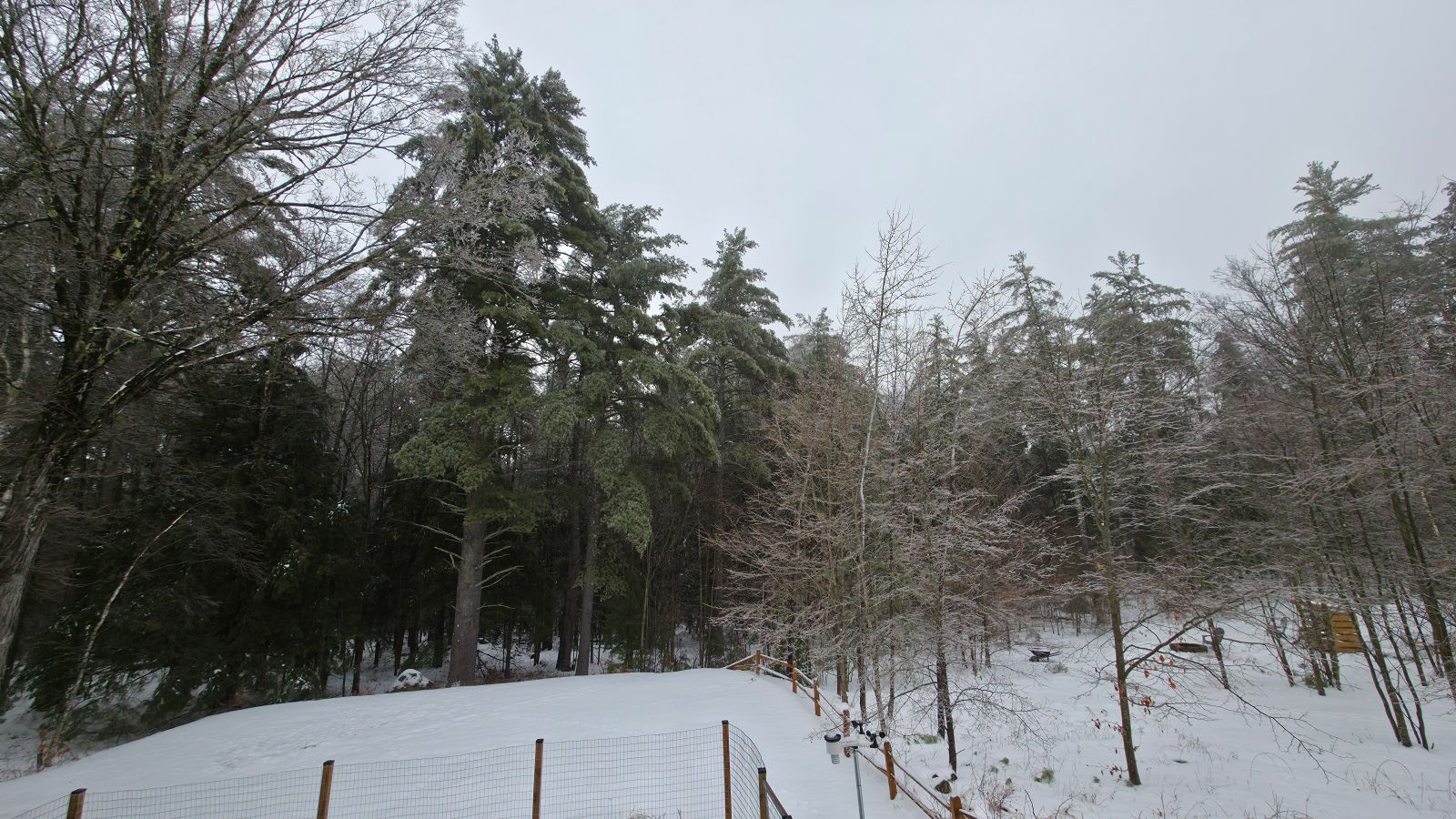
Finished with 4.4" here and have close to 12" for December. Not bad at all.
-
Looks like a colder than average December is a lock.
-
Figured this place would be hoppin' after reading the dismal long range thread... @WxWatcher007 This is your fault for retiring!!!
-

Ice Ice Baby December 28-29 Storm Discussion
dryslot replied to Baroclinic Zone's topic in New England
IP/ZR this morning 31°F -

Winter cancelled/uncancelled banter 25/26
North and West replied to Rjay's topic in New York City Metro
. -
GEFS shows a terrible pattern in the long range with the -PNA returning pretty much cooking winter for weeks. EPS looks better but still not a slam dunk pattern either. Some slight changes have led for it to be warmer for most in the 7 to 14 day period. Let's hope the-NAO can trend stronger. Still not confident the Pacific is going to help us at all this winter.
-

Ice Ice Baby December 28-29 Storm Discussion
CT Valley Snowman replied to Baroclinic Zone's topic in New England
33 here and rain. About 4 miles east it's 40-42. -

Ice Ice Baby December 28-29 Storm Discussion
QuietCorner replied to Baroclinic Zone's topic in New England
Foggy upon waking up this morning and we're at 39 degrees so far this morning. -

Ice Ice Baby December 28-29 Storm Discussion
dendrite replied to Baroclinic Zone's topic in New England
So latent heating works both ways. Everything trying to melt now is acting to help cool the air. I always think of it as like a conservation of thermal energy. The ice is trying to go to a higher energy state now (solid to liquid) so it needs to gain heat for the phase change…hence it’s “taking” it from the air around it. That’s why we tend to rot at 32° so often or frequently see isothermal 0°C layers aloft. So even though the diabatic heating quickly warmed us up to 32°, the melting now is trying to help us stay there. So we’ll see how long the wedge can hold now before the cold fropa blows through later. -

January 2026 Medium/Long Range Discussion
SomeguyfromTakomaPark replied to snowfan's topic in Mid Atlantic
I like the potential around day 10 on the EPS, 0z euro op close to something too. -
Slightly above even works for us too.
-
I got 1"/27mm of rain yesterday. With the intense LES of 8"/20cm and awesomely my new years eve was charged up to 10"/25cm, will be the most intense winter wx for the final days of any year I've ken. Tomorrow 7cm and still breezy has a sum of 20" in the next 72 hr!! Consensus still giving me snow every day til Jan 6.
-

2025-2026 ENSO
40/70 Benchmark replied to 40/70 Benchmark's topic in Weather Forecasting and Discussion
Completely reasonable take. -

Ice Ice Baby December 28-29 Storm Discussion
Lava Rock replied to Baroclinic Zone's topic in New England
32.5F. Was plain rn when I left for work. No need for sand to get out of driveway, but backs roads weren't great. Met a guy backing his lumber delivery truck down Tenny Hill thinking he was going to make it up the 15% grade. I told him to wait it out at the bottom at least 30min and try again as it was starting to slowly warm up. -
MSP recorded 5.8” of snow yesterday. Not sure how much if any was recorded after midnight to add to the final total. Roads are a sheet of ice this morning.