All Activity
- Past hour
-

February 2026 Medium/ Long Range Discussion: Buckle Up!
wasnow215 replied to Weather Will's topic in Mid Atlantic
West Chesterfield/Magnolia Green area got hit hard on December 9 or whatever that Monday was. 5 inches here -

Winter 2025-26 Medium/Long Range Discussion
TheClimateChanger replied to michsnowfreak's topic in Lakes/Ohio Valley
Some light at the end of the tunnel, especially for our western friends. -

Pittsburgh/Western PA WINTER ‘25/‘26
colonel717 replied to Burghblizz's topic in Upstate New York/Pennsylvania
Looks like we get a relaxation next week and wait to see how this polar vortex disruption affects us. I hope we stay snow covered until May... Polar vortex to lock brutal cold over eastern US for most of February Brutal midwinter cold is settling in across the eastern United States, and forecasters say it is not leaving quickly. A disrupted polar vortex is expected to keep Arctic air locked over the region through much of February, turning what is already a harsh stretch into a prolonged test of infrastructure, energy systems, and basic winter preparedness. Instead of a quick cold snap, the pattern shaping up points to repeated waves of frigid air, severe wind chills, and frequent storms tracking along the boundary between deep cold and milder air to the south. I see a setup that blends complex atmospheric science with very down-to-earth consequences, from higher heating bills to dangerous commutes and stressed power grids. At the heart of this pattern is a weakening and splitting of the Polar Vortex high above the Arctic, a process that specialists link to sudden stratospheric warming. High in the atmosphere, a rare burst of warmth is disrupting the typically tight ring of westerly winds that circles the pole, a structure that High Arctic winds Typically keep the coldest air bottled up. When that ring weakens or breaks, lobes of frigid air can spill south into midlatitudes, opening the door for the kind of persistent cold now aimed at the eastern United States. Meteorologist By Andrej Flis has described how New model guidance points to a Polar Vortex split and collapse in midmonth, following a Strato event that is already underway. That breakdown is expected to send major ripples through the jet stream, favoring blocking patterns that keep cold air parked over North America and Europe well into late winter and early spring, a scenario detailed in Polar Vortex research. Closer to the surface, the practical takeaway is simple: Additional cold surges through February are likely, and the odds of Much below normal temperatures across the eastern United States are high. Long-range outlooks highlight a corridor from the Great Lakes and Ohio Valley to the Mid-Atlantic and New England where the freezer will stay open, a trend underscored by guidance that points to Additional surges of Arctic air. For residents from Atlanta to Boston, that means fewer thaws and more days when high temperatures struggle to climb out of the teens or 20s. Forecasters are also watching how this entrenched cold will interact with storm systems tracking along the jet stream. A much larger storm that expert Pastelok has flagged for just before midmonth could tap into Gulf and Atlantic moisture while running into entrenched cold, a combination that often produces heavy snow, ice, and strong winds. That potential high-impact system is already being scrutinized in February outlooks, which emphasize that the stormy start to the month may only intensify as the Polar pattern matures. Forecasts suggest that the polar pattern will not flip quickly. The polar vortex will keep the frigid pattern locked over the eastern US through much of the month, with cold air repeatedly reloading behind passing storms instead of retreating north. Meteorologist Alex Sosnowski has described how this setup effectively leaves the freezer door ajar, allowing frigid air to escape southward again and again, a dynamic laid out in Alex Sosnowski analyses. Parallel guidance from dedicated winter pattern outlooks reinforces that the Polar configuration favors sustained cold rather than a quick thaw. Even as the stratospheric event evolves, surface impacts will unfold in waves, not all at once. While the surface impacts usually lag the initial stratospheric warming by a week or more, the breakdown now underway has already been flagged in Typically delayed discussions of the event. Additional seasonal outlooks stress that Much below normal temperatures should persist across the eastern United States into early spring, with Additional cold surges through February reinforcing the chill, a message repeated in Additional outlooks. For now, the science points in one direction: the polar vortex is faltering aloft, and the eastern United States is squarely in the path of the cold that follows. -
Evap cooling
-

E PA/NJ/DE Winter 2025-26 Obs/Discussion
Birds~69 replied to LVblizzard's topic in Philadelphia Region
31F @ 3pm/Sunny...hanging tight. -
2025-2026 ENSO
TheClimateChanger replied to 40/70 Benchmark's topic in Weather Forecasting and Discussion
Wow! Those were legitimate cold months. Surprised 2015 isn't on that short list as well! -
The HRRR isn't even as good as a broken clock. I've never seen it do well outside of six hours. SREF's same
-
SE ridge develops on most models.
-

Central PA Winter 25/26 Discussion and Obs
Jns2183 replied to MAG5035's topic in Upstate New York/Pennsylvania
We seem to be losing the magic. 5 hours without a post is criminal Sent from my SM-S731U using Tapatalk -
All the models are dry and then 2 rainstorms Valentine’s Day weekend… plenty of time for they to change though hopefully it does
-
36F The individual ice chucks are now going to melt into big mountains of ice chunks that will still be around come June.
-

2025-2026 ENSO
donsutherland1 replied to 40/70 Benchmark's topic in Weather Forecasting and Discussion
I'm not sure what data was used to for the run-up in the price, much less the plunge. I suspect that the dramatic shift in the CFSv2 started the sell-off. The latest ECWMF weeklies were not yet available. In the larger scheme of things, this was not looking like a Top 3 coldest February since 2010 nationwide. Using AmWx's Top 10 forecasters from 2025, here were the expected February numbers: IMO, that consensus consistently beats most of what is posted on Social Media for long-range ideas, perhaps because there is no incentive to hype for clicks, views, etc. Here are the Top 5 coldest Februaries since 2010: #1: 2021 #2: 2010 #3: 2019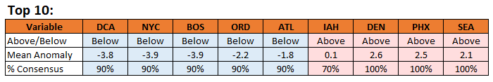
-
My home weather station is up to 38.1 degrees. Melt!!!!
-
35.8, blew away the forecast high of 31. Typical for around here.
-
Blizzard season. Where exactly can one experience this weenie wonderland? Tug hill maybe? UP of Michigan? Blizzard season.
-
2025-2026 ENSO
TheClimateChanger replied to 40/70 Benchmark's topic in Weather Forecasting and Discussion
-

E PA/NJ/DE Winter 2025-26 Obs/Discussion
BBasile replied to LVblizzard's topic in Philadelphia Region
Just hit 32F for the first time in 9 days. -
Hit 34° so far today. Feels balmy out there
-
I shoveled during the storm, but I’m not sure how much difference it made in the end. I think I probably ended up expending more energy than if I’d just shoveled once, but the bright side I guess is that I was able to drive out the morning after the storm without re-shoveling the driveway. Car handled 4 inches of compacted sleet just fine. When I got around to actually shoveling (like you, that meant breaking it up and THEN shoveling) was when I started second-guessing my choices, hehe.
-
why is Newark 36 and Millville 30 at 2 PM ? RWR from KOKX
-

WxUSAF's weak ass frontal passage thing.
NorthArlington101 replied to dailylurker's topic in Mid Atlantic
HRRR still pretty juiced but it shifted things south this run. Not gonna worry about this one much til tomorrow... would really just like a dusting -
At this point we all at least experienced a solid period of real winter with a decent snowstorm and sustained cold. Would have been nice if a couple of additional snow events panned out? Absolutely! But at this point all I'm looking for is one more solid storm to bookend an acceptable winter.
-
Who said we are going to waste it ?
-
He’s the biggest moron I’ve ever come across in my life. Hands down. If you put his brain in a bird it would fly backwards and upside down
-
It feels almost worse than December 2000 did in some ways. I am sorry that happened to you for sure.


