All Activity
- Past hour
-

2026-2027 Super El Nino
bluewave replied to Stormchaserchuck1's topic in Weather Forecasting and Discussion
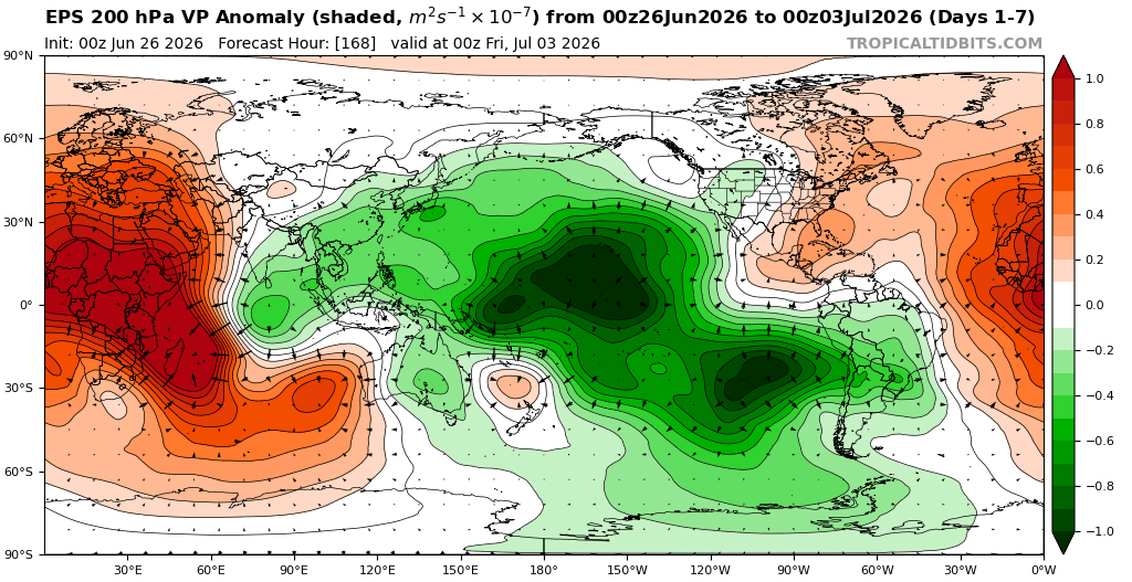
Our last two super El Niños had at least 33% of the time forcing during DJF near the Maritime Continent. December 2015 Maritime Continent forcing transitioned to El Niño forcing in January and February. This was the strongest El Niño on record. 2023-2024 also had the 30% of the time Maritime Continent forcing in January. -
Evergreen posts in this subforum.
-

super el nino banter thread
snowman19 replied to forkyfork's topic in Weather Forecasting and Discussion
I see the usual delusional weenie suspects are peddling the wishcasted fantasy that this is going to somehow magically become a full blown Modoki. Same clowns, same circus. Every year like clockwork, you can set your watch to it with them. Soon, the 57-58, 65-66, 76-77, 77-78, 02-03, 04-05, 09-10 and 14-15 “analogs” will be flying…….. -
Happy Birthday @stormtracker
-
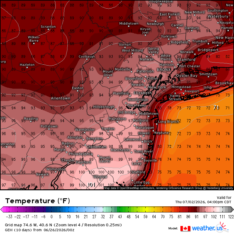
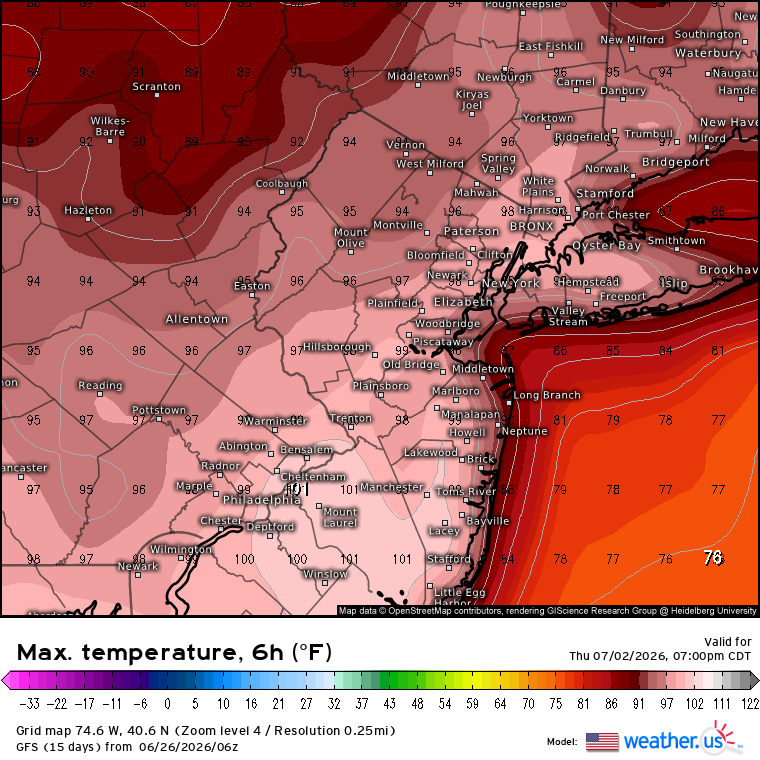
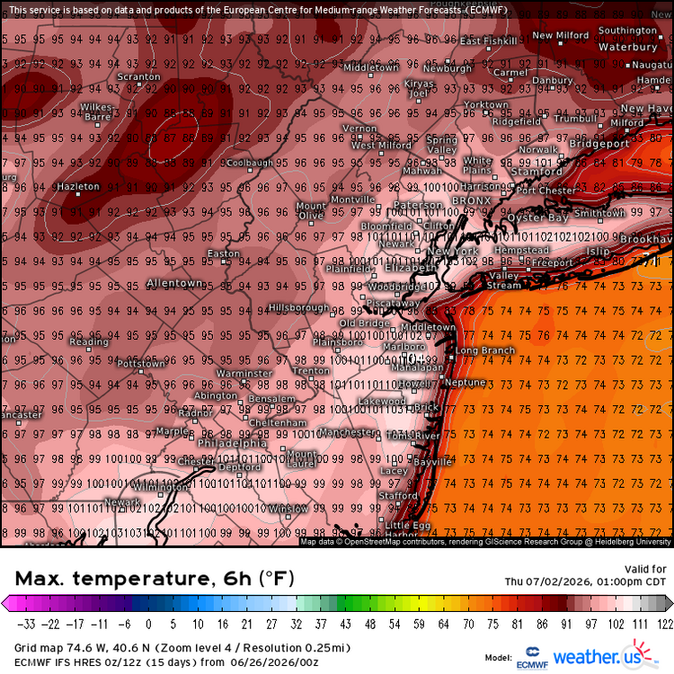
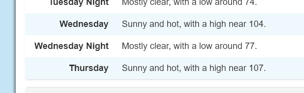
Right now 95°-99° like the GFS and GEM looks like the floor. The ceiling is probably around 100°+ like the Euro has. Unfortunately, this will continue to dry things out.


-
This is the highest I have ever seen in my point and click:
-
2026-2027 Super El Nino
snowman19 replied to Stormchaserchuck1's topic in Weather Forecasting and Discussion
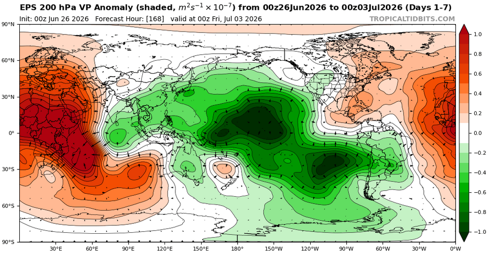
Typhoon season in the PAC is about to explode. Powder keg setup. More WWBs in their wake to come….. -
Need the remnants of a tropical system at this point
-
2026-2027 Super El Nino
bluewave replied to Stormchaserchuck1's topic in Weather Forecasting and Discussion
As the globe keeps warming the +30C areas will become 31C and eventually 32 C etc…Right now once we approach 30 C, that is were the forcing tends to gravitate toward. The coming heatwave will have a combination of forcing from the Maritime Continent to the Nino regions. So at this time the more westward forcing will be driving the bus so to speak.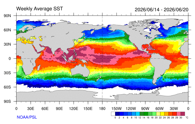
-
Another couple of hundredths. Congrats to everywhere north of the south shore and central nj .
-
61/64 .19" so far.
-

2026-2027 Super El Nino
GaWx replied to Stormchaserchuck1's topic in Weather Forecasting and Discussion
Yep. This is fantastic news for prospects to relieve the terrible SE drought! Couldn’t have better prospects. Nearly the exact opposite of last fall/winter’s drought inducing La Niña. -
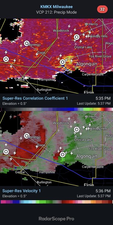
EARLY IN THE WEEK, THERE LOOKS TO BE LITTLE RELIEF FROM LAKE BREEZES OR UPSTREAM CONVECTION AS SUBSTANTIAL CAPPING AND THE STRENGTH OF THE RIDGE DEFLECT MOST ACTIVITY WELL TO THE NORTHWEST OVER MINNESOTA AND NORTHERN WISCONSIN.
-
Thinking about work bullshit woke me up at 4. Gonna be almost as longgggg a day
-

Occasional Thoughts on Climate Change
donsutherland1 replied to donsutherland1's topic in Climate Change
Excerpts from World Weather Attribution concerning Europe's record-breaking June heatwave: Fossil fuel emissions have rapidly worsened European heatwaves in just a few decades Over the region studied this heatwave is the most severe ever recorded. In 1976, when some of the previous European records were set, the 2026 temperatures would have been virtually impossible to occur in June, while also highly unlikely at any time of the year. In 2003, the first major heatwave of this century, daytime heat like this would still have been very rare, about 10 times less likely than today, while nighttime temperatures such as this June would have been more than a hundred times less likely in 2003. Across large parts of Western Europe, June is warming faster than any other month. In addition, daily maximum temperatures are warming faster than night time temperatures, though both are warming much faster than global warming. The hottest daily temperatures are warming at about triple the rate of global warming and night time temperatures at about twice the rate. Many capital cities are experiencing not only their hottest June 3-day period but also the hottest three-day period since 1950, according to the ERA5 dataset. However, due to global warming, these very high temperatures are now expected regularly during the summer months in many capitals. This means that a similar heatwave in June would have been about 3.5°C cooler during the day in 1976 and about 2°C cooler in 2003. The nighttime temperatures would have been about 2.4°C cooler in June 1976 and about 1.3°C cooler in June 2003. This June 2026 heatwave occurred under a circulation pattern broadly similar to historical analogues – Southerly Flow. However, a similar circulation pattern now produces significantly hotter temperatures than it did in the mid-20th century because the climate baseline has warmed... This summer shows that at 1.4°C of global warming, extreme heat is already reaching the limits of our societies’ ability to cope. Our analysis here shows that intense heat is increasing rapidly even in living memory, with such events tens to hundreds of times more likely since only 2003 and virtually impossible just 50 years ago. A rapid phase-out of fossil fuels is critical if we are to avoid even higher temperatures and their consequences in the future. https://www.worldweatherattribution.org/fossil-fuel-emissions-have-rapidly-worsened-european-heatwaves-in-just-a-few-decades/ - Today
-
Summer
-
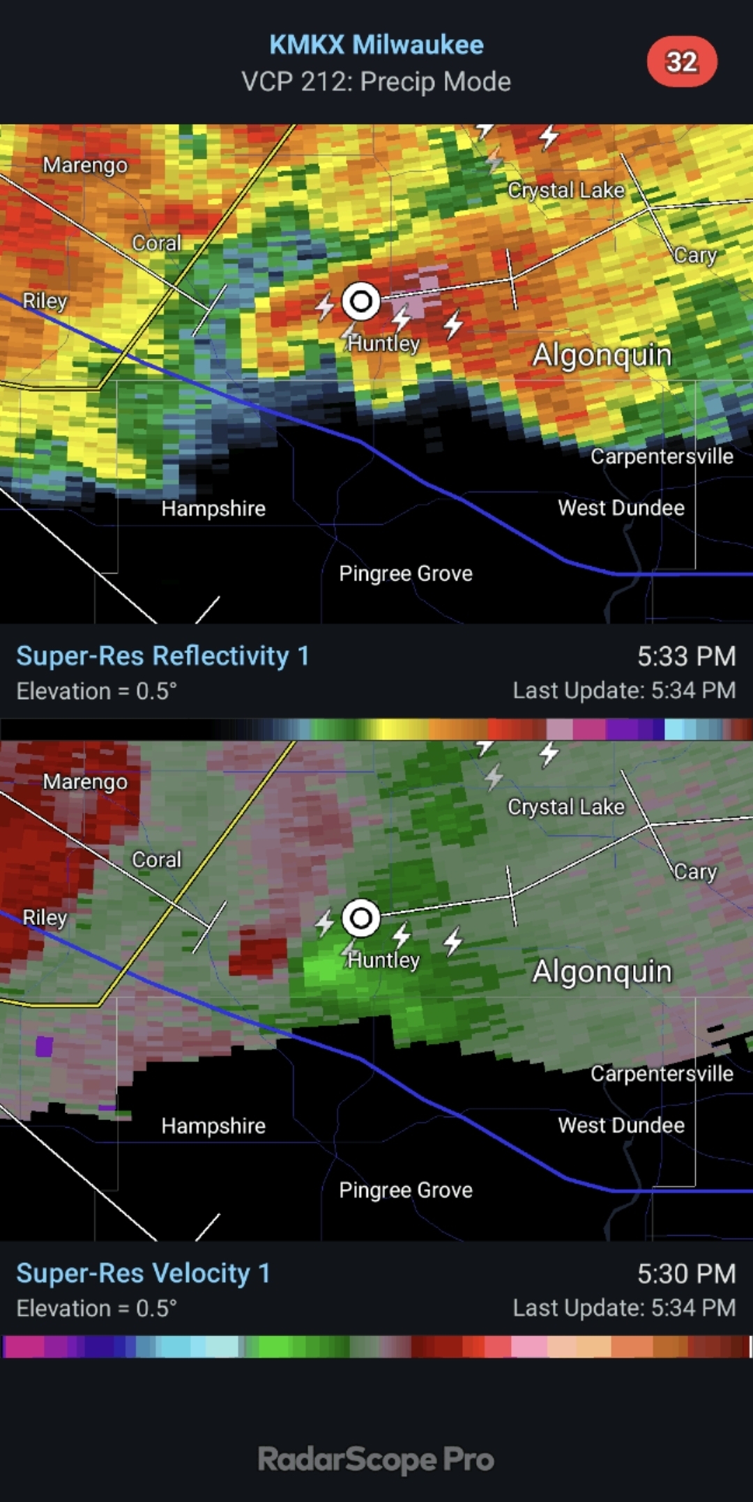
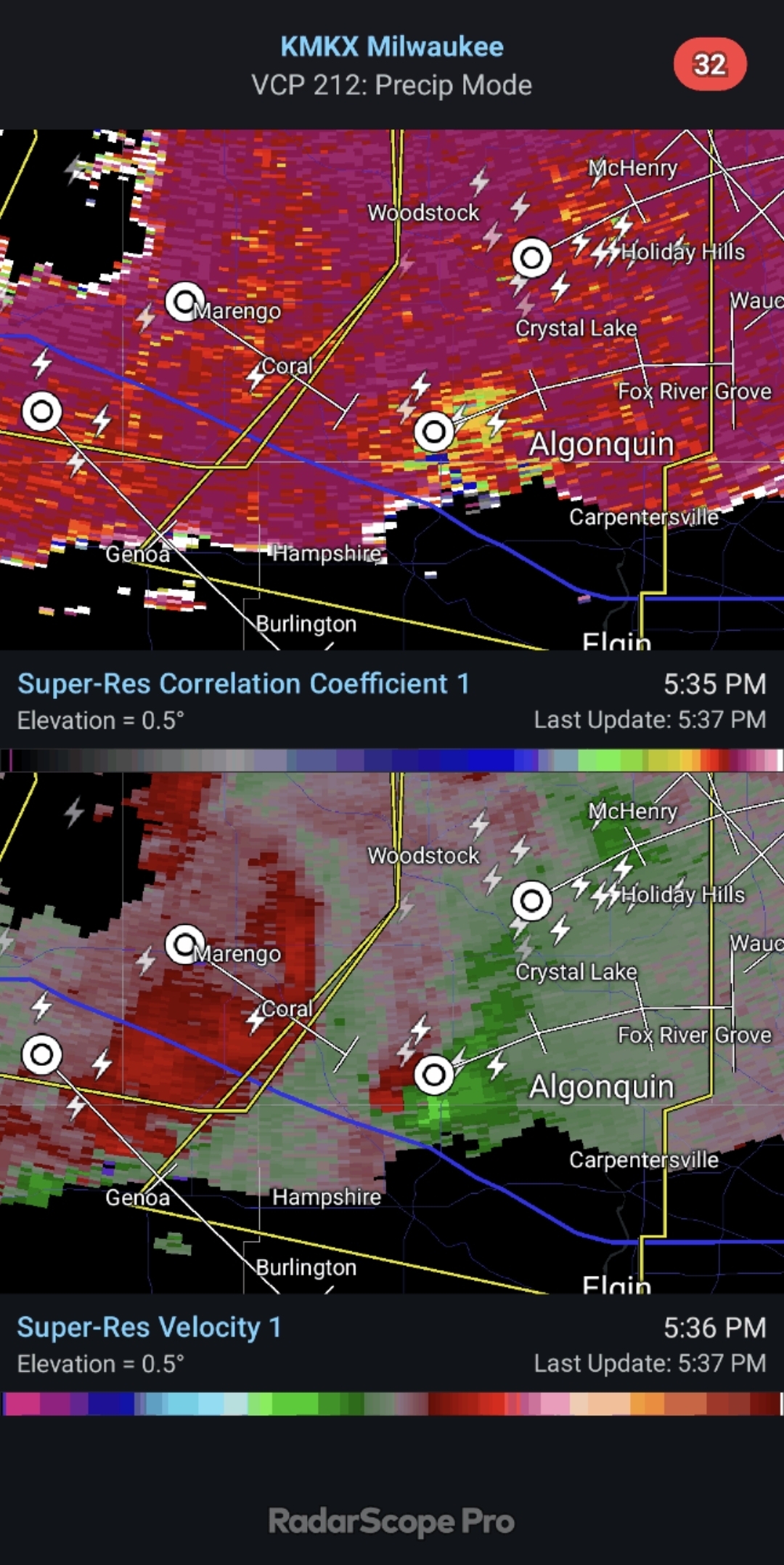
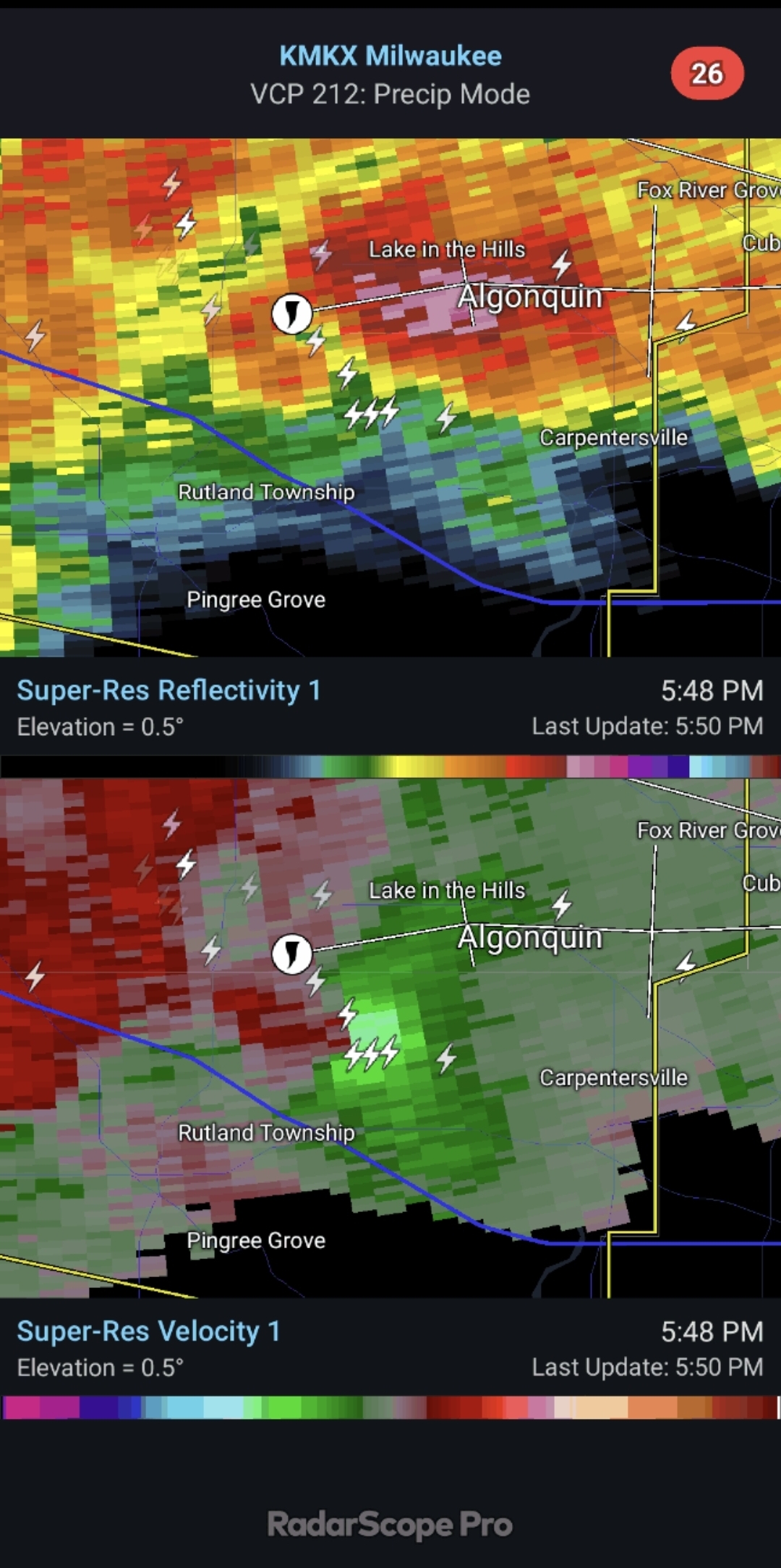
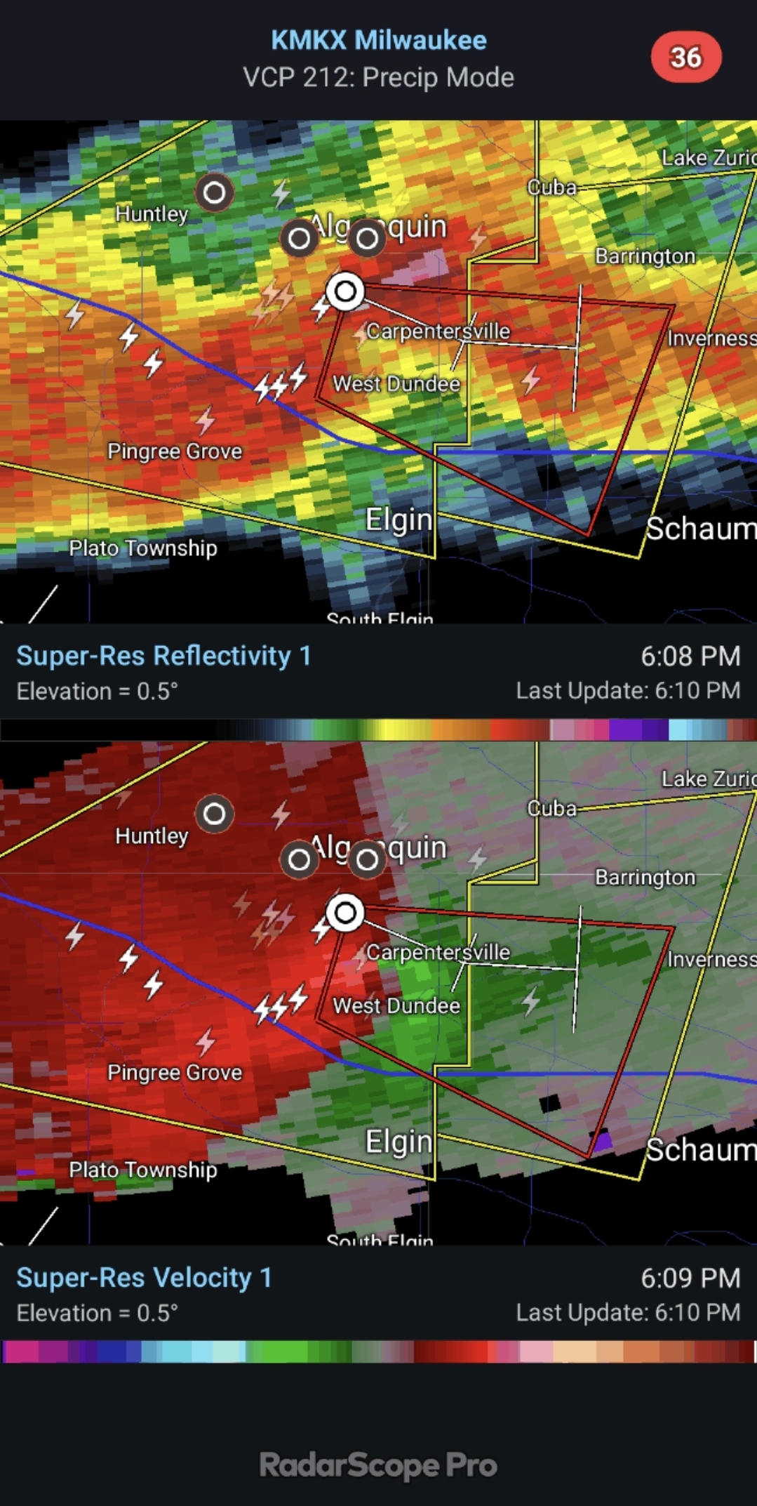
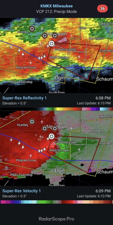
https://www.shawlocal.com/northwest-herald/2026/06/25/why-were-there-no-sirens-when-tornado-hit-huntley-wednesday/


-
This is not going to relieve any drought for many. Scattered blobs isn’t going to cut it.
-
Got drenched here last night, about 1.5" or so. Definitely filled the pool up and won't need to add water. I'm okay if tomorrow misses up here.
-
Triple digits next week?
-
Rain and thunder woke me up at 2. Gonna be a longgggg day lol
-
Finished just a bit under 2”. Some of the hardest rain we’ve had in a long time. Too bad it was so isolated.
-

Junorch obs and discussion 2026
Damage In Tolland replied to Damage In Tolland's topic in New England
It’s been slow to load for several weeks. I’ve had an iPhone longer than your ponytail is -
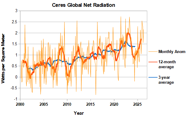
April was another month with very high global net radiation. The running 12-month average is getting closer to the 2023 peak, which occurred in August.
-
Temps in Marquette County this morning ranging from upper 30's inland to upper 40's near shore, 42 here at the house. Probably the last sub-50 morning for a while. Hot and stormy looking good next week.