All Activity
- Past hour
-
Round #2 moving in with a bunch of lightning. Woohoo
-
Early congrats to lower MoCo and points south and east. The light shower earlier had chunky raindrops. Someone down in that batch of precip is gonna score a gully washer.
-

E PA/NJ/DE Summer 2026 Obs/Discussion
Birds~69 replied to PhiEaglesfan712's topic in Philadelphia Region
Rotation?
-
0.77” in the bucket so far today.
-

2026-2027 Super El Nino
snowman19 replied to Stormchaserchuck1's topic in Weather Forecasting and Discussion
Yes. It is extremely well coupled….SOI, OLR/standing wave convection, WWBs/westerlies and GLAAM. Once the +IOD really going the coupling is only going to increase more Record high GLAAM: -
0.77” in the bucket so far today. Well needed.
-
I hope the retiring nam isn't right for my backyard tomorrow
-
.thumb.jpg.6a4895b2a43f87359e4e7d04a6fa0d14.jpg)
Central PA Summer 2026 Discussion/Obs Thread
Yardstickgozinya replied to Voyager's topic in Upstate New York/Pennsylvania
Just to be clear, i'm speaking of tornado genesis, not of severe weather itself.That possibility is very much still there. -

Junorch obs and discussion 2026
Damage In Tolland replied to Damage In Tolland's topic in New England
Yup and there’s nothing but a few showers overnight / early morning . I’m sure you picked one model that shows different -
Glorious in N. Arlington. It’s been steady for at least 30 min, and dumping for the last 15. Heaviest of this particular storm right now. When clean gutters can’t handle the intensity, you’ve generally got a good thing… especially if you grow food. The intensity died down tremendously while writing that post - gutters functioning as intended. Hope for many more of these events. I prefer an inch over a few hours vs. over two days.
-
Congrats central NJ
-
Central PA Summer 2026 Discussion/Obs Thread
Yardstickgozinya replied to Voyager's topic in Upstate New York/Pennsylvania
There's still time for things to happen. The overlap of surface vorticity and cape that they spoke of yesterday looks to be in jeopardy, to me.
-

E PA/NJ/DE Summer 2026 Obs/Discussion
mattinpa replied to PhiEaglesfan712's topic in Philadelphia Region
Moved from my house and am temporarily in Collegeville. Very heavy rain and some wind and thunder but fortunately nothing worse here. -

2026 Mid-Atlantic Severe Storm General Discussion
George BM replied to Kmlwx's topic in Mid Atlantic
A big wind threat might be developing for areas south of I-66 and Route 50 w/ that squall line in VA. -

Wet late Monday 6/22 or another Fizzle?
MN Transplant replied to Weather Will's topic in Mid Atlantic
About an inch from that cell. I’ll still complain if we whiff tomorrow, but not as much. -
Hmm, might get interesting soon on the upper Eastern Shore.
-
If I am guessing your exact location correctly, it appears that some crazy ass storms are on the way from your WSW
-
Visibility down to about 1/2 mile in the downpour near DCA. edit: now more like 1/4 mile.
-
https://x.com/commoditywx/status/2069101636929142827 Eastern heat ridge next week begins to retrograde west and north by holiday weekend, favoring cooler East for July 6th workweek.
-
If it makes you feel any better it’s only lightly raining here and not enough to cancel softball. I’m so sore and tired and could have used a night off
-
Did you look? It sure is
-
my yard is so happy lol
-
E PA/NJ/DE Summer 2026 Obs/Discussion
Birds~69 replied to PhiEaglesfan712's topic in Philadelphia Region
3 seperates blobs. Vegas odds are I miss all 3... 84F/DP 70F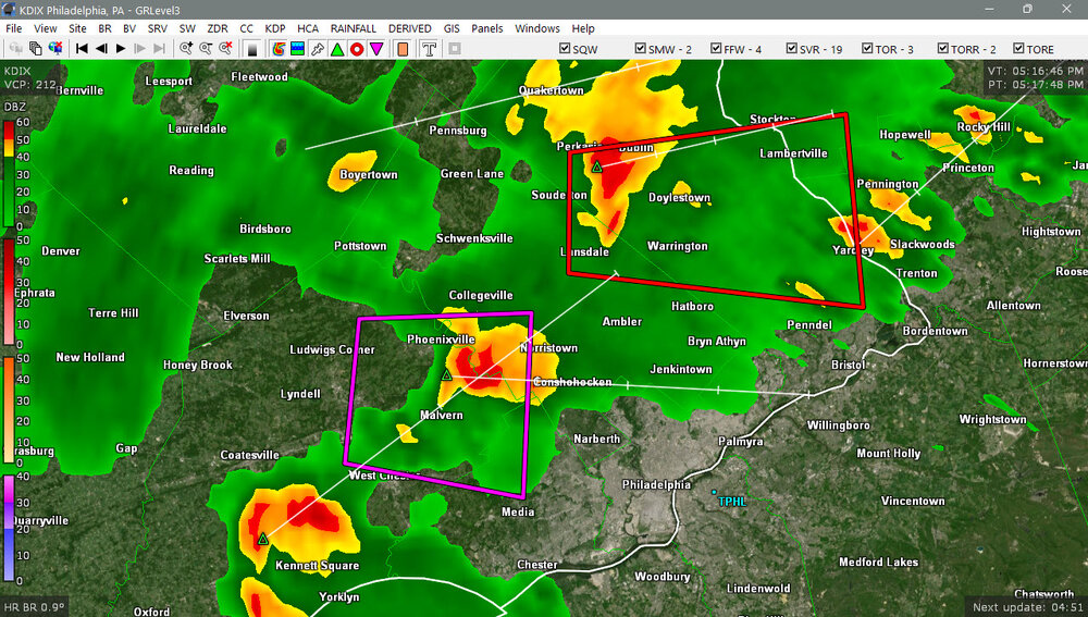
-
was picking up my daughter from camp on the bus and we missed it by about 10 min thankfully. DCA hit 95F before this started coming through, so another 95F+ day in the books.
-

2026 Mid-Atlantic Severe Storm General Discussion
SnowenOutThere replied to Kmlwx's topic in Mid Atlantic
No visible rotation from my vantage point. Massive downdraft/microburst visible though.


