All Activity
- Past hour
-
63F for SST’s off coast of NH https://www.ndbc.noaa.gov/station_page.php?station=44098 For the date that’s normal for south shore Long Island…
-

2026-2027 Super El Nino
snowman19 replied to Stormchaserchuck1's topic in Weather Forecasting and Discussion
-
UNH buoy east of NH already up to 63 degrees…. That’s a month ahead of schedule… https://www.ndbc.noaa.gov/station_page.php?station=44098
-
Looks to hold off til at least 9
-
It seems no enhanced with the 1630z outlook.
-

2026 Mid-Atlantic Severe Storm General Discussion
SnowenOutThere replied to Kmlwx's topic in Mid Atlantic
Interesting how tight the gradient is between Louden county and the DC border. Do you think it’ll fill in west or no? Visual sat shows some clearing. -
Love the 90 degree day tracking. Who's tracking 70+ degree dew point days? Yesterday was a nice respite but back over 70 here inside the beltway. Yuck. Slightly more tolerable with cloud cover and a breeze
-
Some of the best lightning shows I've had have come from nighttime elevated cape events! Not a lot of CGs but lots of CC / CA.
-

2026 Mid-Atlantic Severe Storm General Discussion
Eskimo Joe replied to Kmlwx's topic in Mid Atlantic
Yea buddy! -
This has the one of the most bizarre Euro runs I've ever seen. Develops a tropical storm inland? There's not even a closed low prior to the energy coming ashore. Must be some kind of hybrid thing, but seems mostly warm core. Not even way out in fantasy land!
-
-
Going back to day 2 of All Good Now at Merriweather- hot as hell yesterday but when the sun dropped below the tree line at 7:30 evening was fantastic. Whole day was even with the heat. already 88 as we head over there.
-
81.7/63 Meh on storms. Can't wait for my 2 rumbles and 0.05" to pass through around midnight while 10 miles north gets 1"+.
-
As @high risk indicated I am watching dewpoints like a hawk. The HRRR really mixes things out which it is prone to do - but even some models that keep things moist don't produce much today. We'll see - but I still think somebody is in for decent storms.
-

2026-2027 Super El Nino
roardog replied to Stormchaserchuck1's topic in Weather Forecasting and Discussion
It seems like everything is expected to be permanent anymore(droughts,floods,etc)until they aren't. -
SE MA the thunderstorm capital of eastern MA
-

2026 Mid-Atlantic Severe Storm General Discussion
NorthArlington101 replied to Kmlwx's topic in Mid Atlantic
Rumor is that we are perhaps getting a bump to ENH next outlook. Guess we’ll see. -
We're def getting widespread rain and at least embedded thunderstorms. Just a matter of whether there will be any embedded strong/severe storms, and if so, is it rather localized or more scattered?
-
2026 Mid-Atlantic Severe Storm General Discussion
SnowenOutThere replied to Kmlwx's topic in Mid Atlantic
If we get a bit more clearing then I’m feeling it today. Last week I got back to back days of legit severe storms. One of which was stronger than anything in the past couple years. Something to remember from both days is some CAMs were anemic the day of, so I’m not too worried about them. Additionally, both days last week produced that in spite of no shear. -
Mesoanalysis showing strong CAPE tongue building into the areas east of Frederick or so.
-
I thought for sure last night that cell coming from chapel hill would get western wake but alas nothing! One bright side with the drought is that I don’t think I’ve had to kill a mosquito yet this year. From that perspective it’s been really awesome
-

E PA/NJ/DE Summer 2026 Obs/Discussion
JTA66 replied to PhiEaglesfan712's topic in Philadelphia Region
Trash night, let’s see what happens. 87F/DP 64F -
It’s pretty sultry out there. I’d be shocked if storms hold off too long.
- Today
-

2026 Atlantic Hurricane Season
WxWatcher007 replied to Stormchaserchuck1's topic in Tropical Headquarters
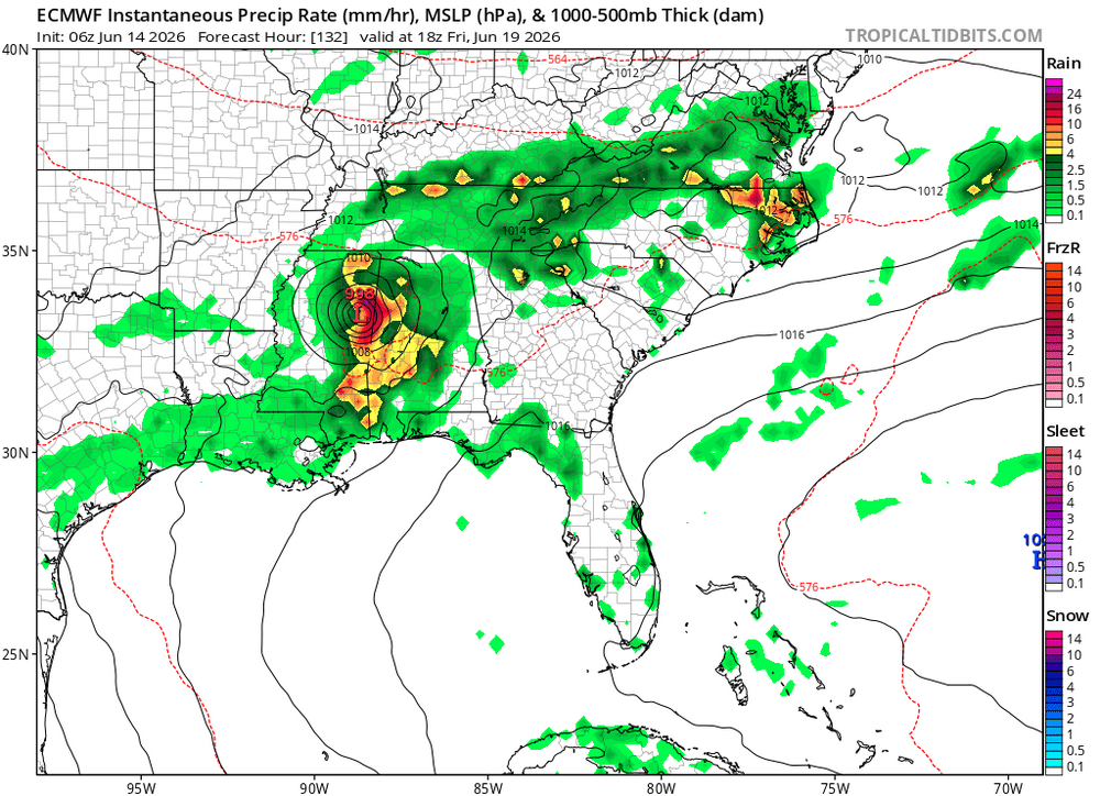
For those still watching, the last two Euro runs do something very weird with our area of interest. It tries to organize it well inland and treks it across the south. Can't say I've seen that before lol. Still a chance for some marginal development later in the week as a front tries to get involved in the NW Gulf. -

Central PA Summer 2026 Discussion/Obs Thread
Voyager replied to Voyager's topic in Upstate New York/Pennsylvania
Despite a few camera malfunctions, I got some video of the Union Pacific Big Boy in Nesquehoning this morning. When I get them edited and uploaded to YouTube, I'll share them here.


