All Activity
- Past hour
-

2025-2026 ENSO
so_whats_happening replied to 40/70 Benchmark's topic in Weather Forecasting and Discussion
Nice 90 day loop -
Looks like a 2nd band sets up further SW at some point later today-that's the only way I'm getting anything
-
HRRR already shit itself. So even a NAM/HRRR compromise is good.
-
This is great for the kids starting school next week. My son walks and his school was having AC issues in June.
-
Do we know where it’s going to rain yet? Lol
-

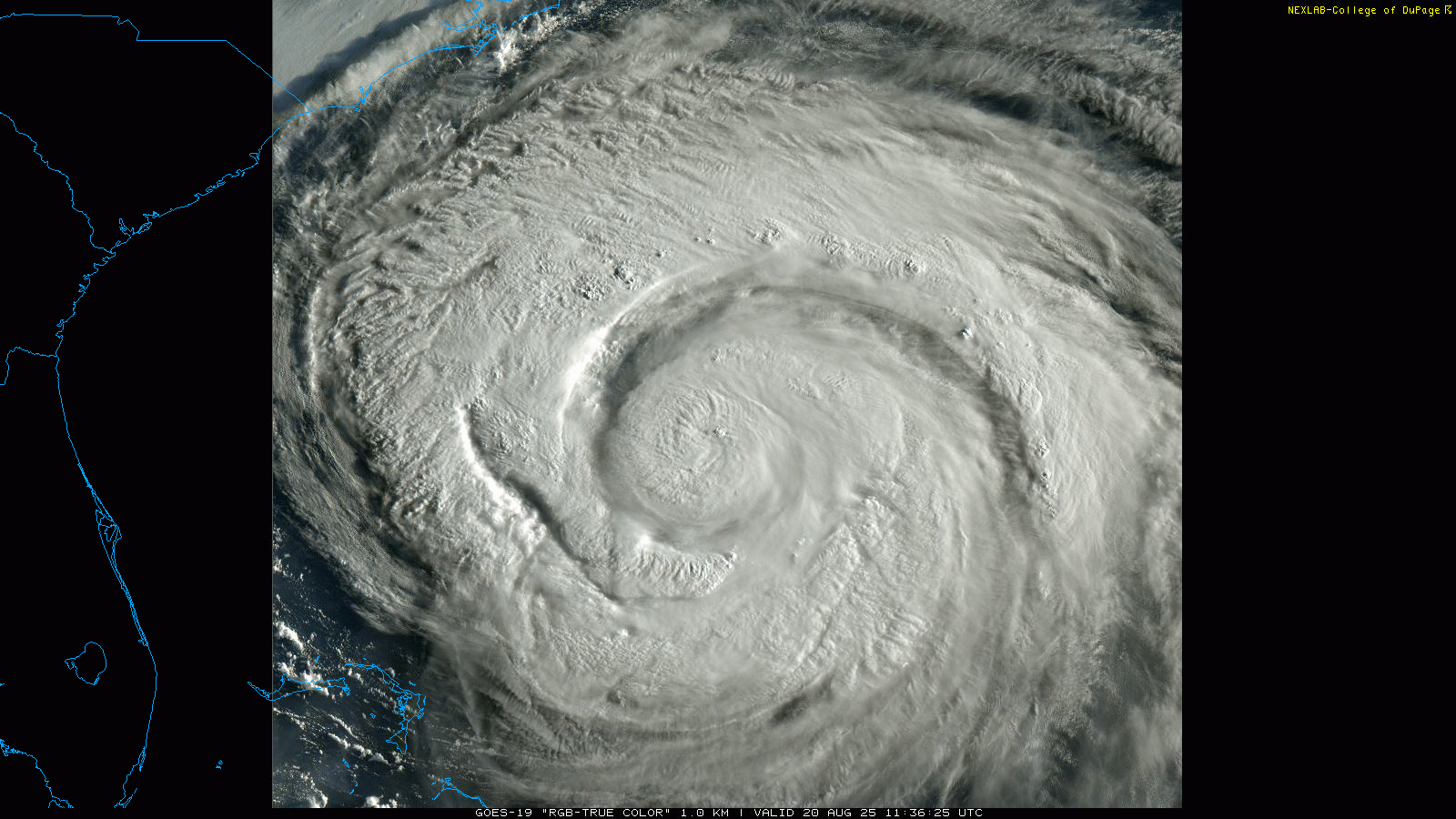
Hurricane Erin: 100 MPH - 954 mb - NNW @ 13
Wannabehippie replied to BarryStantonGBP's topic in Tropical Headquarters
Tropical systems will always grow in size as they gain latitude. -
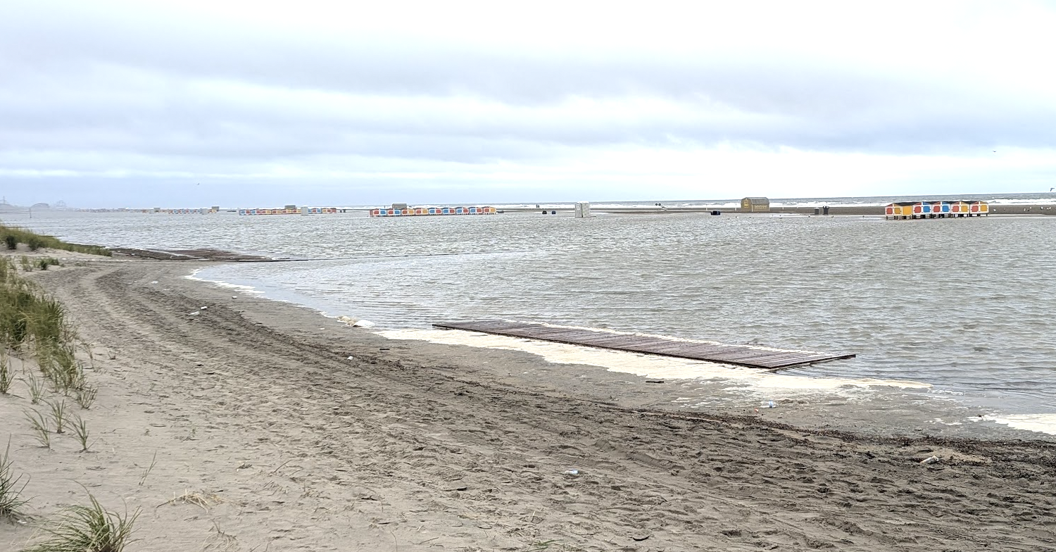
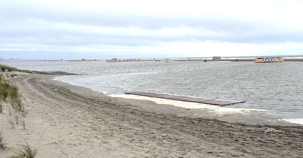
Sustained onshore wind already causing some overwash in wildwood crest, nj; not yet feeling the effects of the 'cane
-
Next week will be a mid-to-late beautiful sky (assuming no wildfire smoke). Looks like we swing some cold pools through. So we could have a scenario of blue sky to begin the day with crisp and bubbly TCUs developing by mid-to-late morning. Moisture is limited but probably see isolated showers/thunder (particularly high terrain).
-
64, an east wind and drizzle. Never a better August day Sent from my SM-G970U1 using Tapatalk
-
Completely agree here ... I said this myself yesterday or the day before. Consideration of straight up climatology, we've topped the curve thus we must be descending. You know it's my fault? ha. Seriously though, I'm the one that first coined that expression like 15 years ago ...'summer's back is broken,' and now I hate it. Mainly because its use is abused. Perfect. However, I don't take anything in here 'literally', nothing from the social media-sphere for that matter. Most of the time I pass over it and let it be/choose not to involve in it. There's no one to defend someone in here - no one comes to anyone's rescue. So I'm saying this shit in my own defense: I post vastly more with Meteorological information, and/or attempt substance worth the time ( for some..) in here in general, compared to the amount of ongoing back-and-forth semantic chicanery that wastes it for most... So once in a while, when reading someone pushing across a concept as fact , when it's merely what they want/bias, it's hard to resist responding - if that's a failing, meh. There are far worse representations and examples out there amongst humanity, too many of them. And if for nothing else, it's just fun to shatter illusions. Although, it's probably a delusion to think it's making any difference.
-
 Drove north through the rain starting in Lavalette; ended south of New Brunswick. Hoping to get something in Chester as it is very dry.
 -
0.19” overnight. Brings us to 4.11” on the month. Moisture from all the rain recently is causing a good deal of morning fog
-

Hurricane Erin: 100 MPH - 954 mb - NNW @ 13
NorthHillsWx replied to BarryStantonGBP's topic in Tropical Headquarters
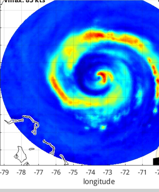
Check out the lighting aligning with the dry slot. Notice there isn’t any around the core. Incredible shot! -
1-2" here seems possible, but I'll go with .75 based on how the last month has gone.
-

E PA/NJ/DE Summer 2025 Obs/Discussion
BBasile replied to Hurricane Agnes's topic in Philadelphia Region
Up to 0.23" of rain this morning. Still a steady drizzle. 65.5F -

Hurricane Erin: 100 MPH - 954 mb - NNW @ 13
olafminesaw replied to BarryStantonGBP's topic in Tropical Headquarters
Wide view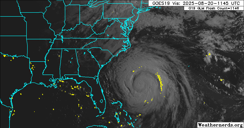
-

Hurricane Erin: 100 MPH - 954 mb - NNW @ 13
GaWx replied to BarryStantonGBP's topic in Tropical Headquarters
The minimum SLP has dropped as the models predicted. It’s down to 948 mb SUMMARY OF 800 AM EDT...1200 UTC...INFORMATION ---------------------------------------------- LOCATION...29.6N 73.7W ABOUT 560 MI...900 KM WSW OF BERMUDA ABOUT 400 MI...645 KM SSE OF CAPE HATTERAS NORTH CAROLINA MAXIMUM SUSTAINED WINDS...100 MPH...155 KM/H PRESENT MOVEMENT...NNW OR 345 DEGREES AT 13 MPH...20 KM/H MINIMUM CENTRAL PRESSURE...948 MB...28.00 INCHES Erin is a large hurricane. Hurricane-force winds extend outward up to 90 miles (150 km) from the center and tropical-storm-force winds extend outward up to 265 miles (425 km). The minimum central pressure reported by the Air Force Hurricane Hunter aircraft is 948 mb (28.00 inches). -

Hurricane Erin: 100 MPH - 954 mb - NNW @ 13
Kevin Reilly replied to BarryStantonGBP's topic in Tropical Headquarters
I think this is 3 years in a row with a Category 5 Hurricane breaking records for date / time / location that to me is enough for pause and wonder as we track hurricanes. Tracking Hurricanes is more than just watching them barrel onshore if it comes to that, but rather learning from them to see how they track, what most effects their track and how it is connected to the overall world climate picture, weather patterns, and even ocean currents. - Today
-
Hurricane Erin: 100 MPH - 954 mb - NNW @ 13
NorthHillsWx replied to BarryStantonGBP's topic in Tropical Headquarters
That dry air entrainment will cap any potential strengthening but with shear low and pressure falls this thing is continuing to grow in size -
Hurricane Erin: 100 MPH - 954 mb - NNW @ 13
olafminesaw replied to BarryStantonGBP's topic in Tropical Headquarters
Just uniquely stunning this morning.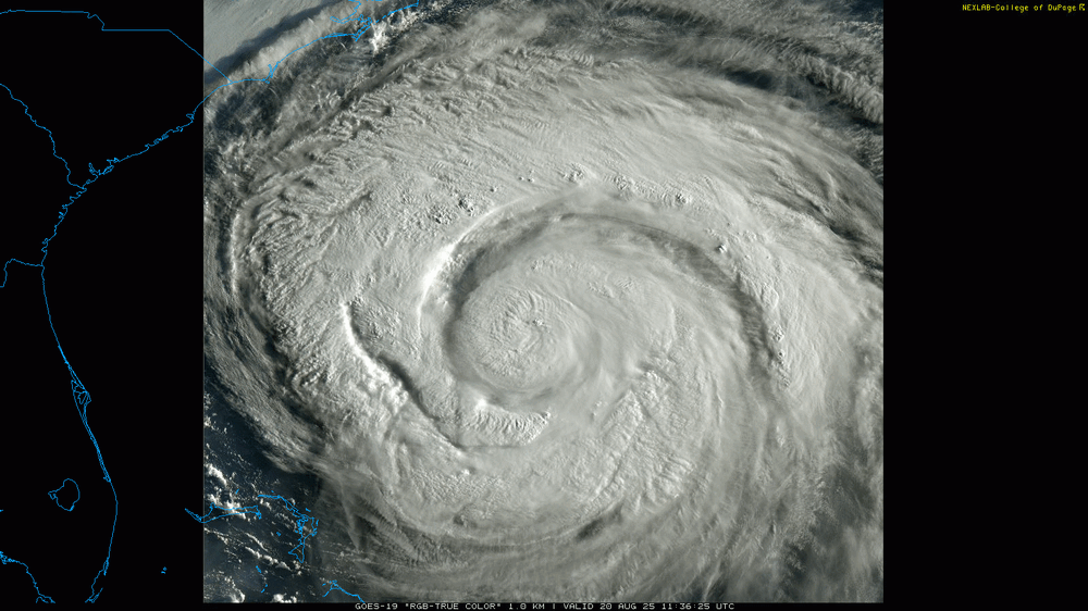
-
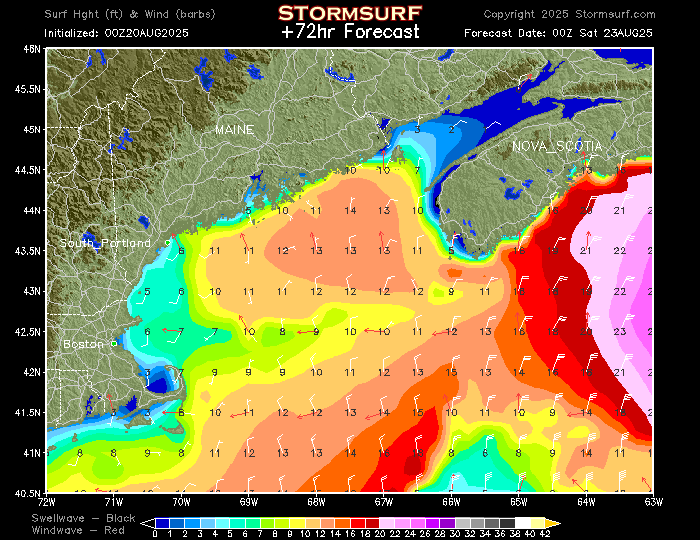
Any Maine surfers here? I know there are other surfers/snowboarders, etc., fishing and boating people. I am mostly in Rhode Island, but also have/will all over Cape Cod, North Shore Mass., South Shore, Mass. Here is the NOAA wave/wind model for a couple of days hence...simply doesn't get any better, at least over past 30 years (and no, I am not worried about "jinxing" or attracting people to certain spots...the ocean will take care of itself):
-
Heaviest is Sop. Maybe near pike as farther north I think. But even NoP gets decent drink.
-
Seems like most places get .50 or so and some narrow strip north of pike into SNH sees 2-3”
-
Hurricane Erin: 100 MPH - 954 mb - NNW @ 13
NorthHillsWx replied to BarryStantonGBP's topic in Tropical Headquarters
To be quite honest, other than Erin not being an annular cat 5 truck tire monster like Isabel, there are a lot of similarities. Its post-peak progression has been about the same and other than slamming headfirst into obx it’s swinging wide right by 150 miles. Current structure reminds me of Isabel a lot when it came into NC -
Hopefully today is the start of some cooler temperatures because the last week has been brutal. The Heat this past 3-5 days has been downright disrespectful!!! On a positive note, the 10-day outlook does look good with low temps in the low 60's next week and highs in the low 80's. It's almost football time in Tennessee!