All Activity
- Past hour
-

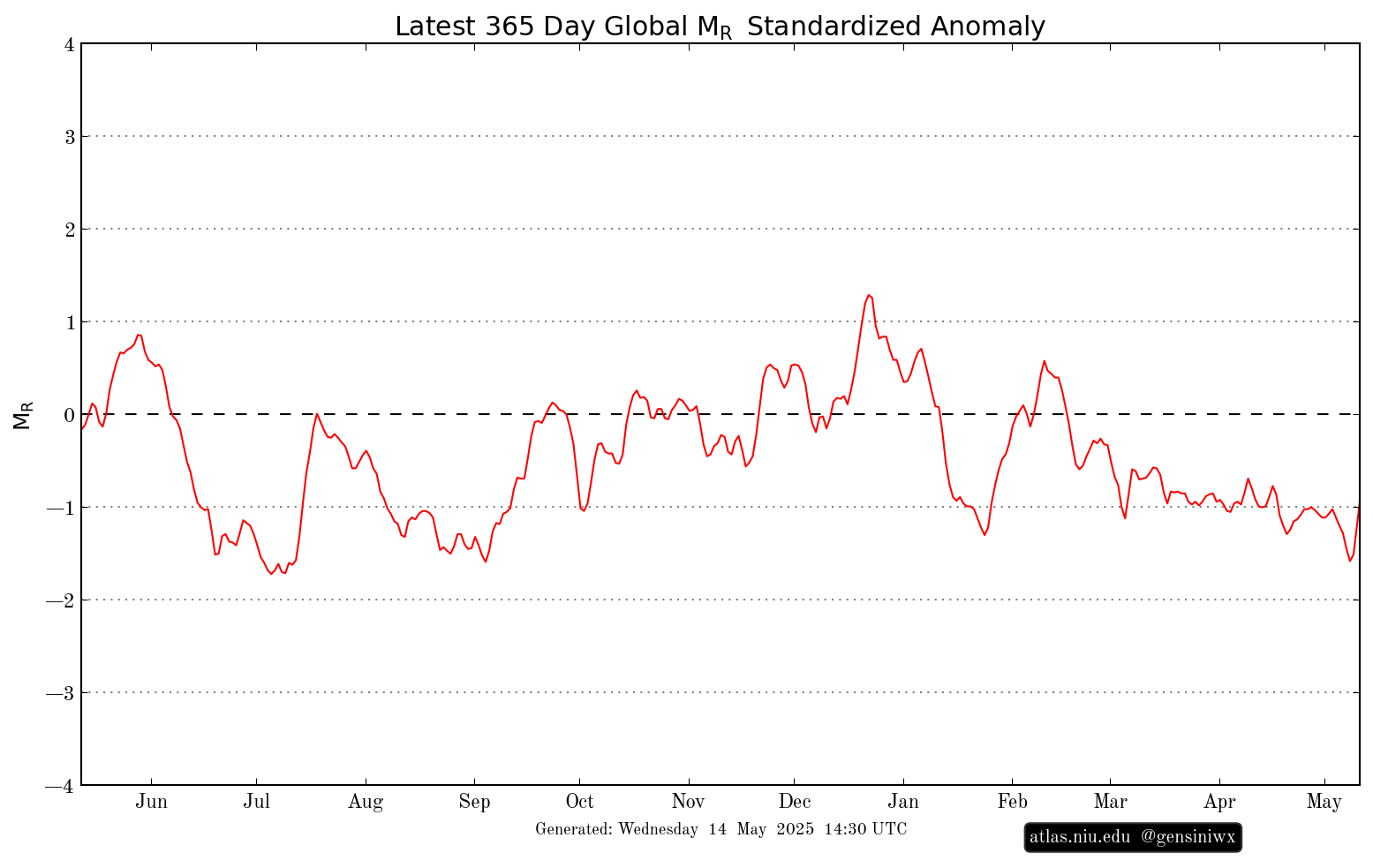
2025-2026 ENSO
so_whats_happening replied to 40/70 Benchmark's topic in Weather Forecasting and Discussion
Yea big reason I feel we see a brief warm neutral state arise by winter time I do not believe the atmospheric state will have enough tipping to allow a Nino like atmosphere throughout but it could very well be a back forth scenario just as we experienced this year. Unless we start to see some pretty drastic reversals occur within the subsurface over the next two or so months. -AAM in full swing which would indicate at least atmospherically there should be a La Nina signal still well about. This will be important in the coming few months for the hurricane season. As others have mentioned, with a -AAM, we should still be seeing a pretty decent PV as we get into winter although it will be interesting to see what happens if we do indeed flip the QBO state by fall/winter. I would not expect record levels like we saw this past year. I do want to see how the pacific typhoon season sets up have yet to see a storm in the WPAC so we may very well see a record again for the latest system to form. The monsoon looks to be rather weak but starting up toward the end of the month across SE Asia. It looks like we continue with the cool tongue/ -PDO look from the Baja to the central Pac with brief bout of warming into Nino 1+2 and 3. Been awhile since I have looked but thoughts a modoki/ west based la Nina pattern trying to setup?
- Today
-

E PA/NJ/DE Spring 2025 Obs/Discussion
RedSky replied to PhiEaglesfan712's topic in Philadelphia Region
1.20" total for Wednesday -
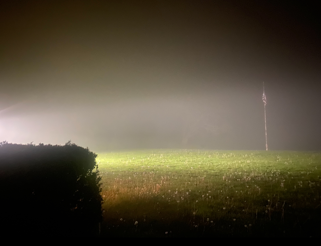
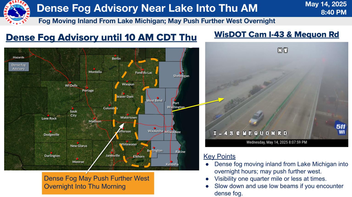
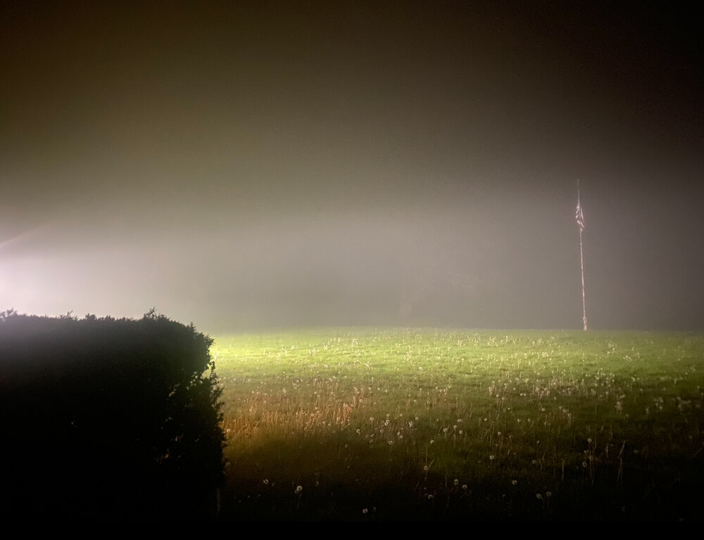
Another fairly impressive marine layer next to the lake again today/tonight. I’d guesstimate about 1/4-1/2mi visibility right now. Go just a few miles inland and it’s clear. Am I weeny enough when fog gets me excited? (And don’t give me shit about my lawn I’m a renter lol) Edit: Way below even 1/4mi now just before midnight. This is really isolated to very close to the lake but pretty impressive. Can’t see the flag at all now in my original pic.

-
 edit your original post to change the title.
 -
Damn I’m good.
-
that whole run had barely any warm days
-
ya I really don't get how some think its a massive job that takes hours to do
-
Shut em down, airtight, AC, and spawn children you have to take to the emergency room with one whiff of peanut butter.
-
 MODS, given the increasing severe weather threat on friday across the southern portion of the subforum, can we add 5/16 to the title?
 -
I was thinking about this earlier. We've put them in later, but I agree, usually they'd be in by now. Considering how next week looks, we might make it to June without them.
-
Even if we lower the dew points, it's the lapse rates that are driving the huge instability. Some sort of remnant EML appears likely to advect into our area overnight Thursday - there is really good, continued model agreement this evening about that. (Toss the GFS/HiResW FV3 which are known to underdo lapse rates.) The impressive lapse rates will allow some sort of MCS to survive into our area early Friday and then enhance whatever severe threat exists Friday afternoon. I'm still not totally sold on a trigger (yeah, a leftover boundary from a morning MCS could help a lot), and we might have some downsloping subsidence to suppress convection, but the shear/instability profile would favor splitting supercells with a wind and very large hail threat if any storms can form. (The tornado shear profile shown in the forecast sounding above is not supported in this evening's guidance which generally shows more westerly surface winds.)
- 509 replies
-
- 2
-

-

-
- severe
- thunderstorms
- (and 2 more)
-
.35" for the day. 6.57" for the month
-
My event is now up to 2.36”. Just had a small batch of moderate rain come through.
-

E PA/NJ/DE Spring 2025 Obs/Discussion
MGorse replied to PhiEaglesfan712's topic in Philadelphia Region
Finally cashed in! Two day total of 3.05 inches of rain, most of which fell today. -
Forecasts for the main stem rivers in this area have now been upgraded from minor to moderate flooding, and with a longer duration, per the NWS update at 9:30 this evening.
-

2025-2026 ENSO
Stormchaserchuck1 replied to 40/70 Benchmark's topic in Weather Forecasting and Discussion
I definitely expect the PDO to start changing, maybe because of this more active solar period. One "bone" with this is, +3-6 years after a Strong Nino and +2-5 years after 4/5 La Nina's, we see El Nino's happen over La Nina's about 2:1.. I think we have a higher likelihood for El Nino in 26-27 and/or 27-28.. that may help to change the PDO, ideally. I do think this La Nina cycle that we have been in since 98-99 won't last much longer. We had near record winds in the Northern Hemisphere this Spring.. that is +pdo How impressive is the global temperature though with 14 La Nina's and 8 El Nino's in the last 27 years.. if ENSO was more even, it would probably be an even higher global temperature over that time (and it's already kind of gone exponential). -

2025-2026 ENSO
40/70 Benchmark replied to 40/70 Benchmark's topic in Weather Forecasting and Discussion
No, I agree with all of this...I wasn't trying to imply that I expect to enter the -NAO muiltidecadal cycle around the next solar min...I meant literally maybe one season that averages more negative. My larger point concerning solar min is that if we don't see a good winter through the next solar min, then I will start to consider CC as a larger contributor. I do not expect a flip in the NAO decadal cycle....PDO, I do. -
Can’t see that far east on this but I’m going to be in PEI that week. I really don’t want that bullshit.
-
Awesome
-
As north of the pike once said "A literal monkey can do it"
-
2025-2026 ENSO
Stormchaserchuck1 replied to 40/70 Benchmark's topic in Weather Forecasting and Discussion
Yeah, I'm just saying the cycle is long so it could take decades to fully change.. Since Winter 11-12, 83% of the Winter months have had +NAO [CPC]... Given that we are still near the peak and active Solar Max, I would say the odds right now are 70-75% that next Winter is +NAO (DJFM). I agree that it should start coming down after that, but it may take up to 20 years to leave the decadal +NAO state. The 1920s were very positive, and although the 1930s did see a substantial drop, the 1940s and early 1950s went back to positive.. if you smooth that all out, it's about 20 years after a peak phase for it to come down to neutral. I would say the Solar Min in the late 2030s is the big one. Also just being outside in the Winter.. I can feel the Atlantic subtropical jet, see it in the cloud cover and stuff. That's why I've kind of intuitively known that snowfall isn't big for the last 10 or so years. And I still feel that as strong, being near a peak, no change anytime soon. -
This might as well be written in mandarin Chinese to me
-
2025-2026 ENSO
40/70 Benchmark replied to 40/70 Benchmark's topic in Weather Forecasting and Discussion
Maybe so, but we should get thrown a bone around or shortly after solar min. -
 00z HRRR gets way too warm down south, outflowy/hail-driven mess if that's the case. Still has a few supercells in Wisconsin. Edit: And shows what would likely be a major severe weather outbreak on Friday across the OV/Mid South.
 -
Just shy of 2 inches... currently at 1.98 here in 21057