All Activity
- Past hour
-

January 2026 regional war/obs/disco thread
Damage In Tolland replied to Baroclinic Zone's topic in New England
1-3” NYE… 1-3” Sunday We’ll take it. Better than cold and dry -
Much better actually i think, I eat both, Cut the bodies, Cut off the heads clean and rinse, Recipe is simple for these, 2 tbl spoons Salt, 1c Flour, I place them in a zip lock, Shake them up and fry them in cooking oil, It makes them crispy, Supermarkets or fish mkts up here will carry them in season too. https://www.allrecipes.com/recipe/236481/fried-smelts/
-
All that H off the coast will do is screw us.
-
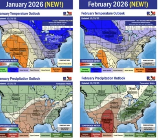
Bam is above normal for February
-

Winter 2025-26 Short Range Discussion
A-L-E-K replied to SchaumburgStormer's topic in Lakes/Ohio Valley
DAB classic -
Dumping snow in South Russell right now. Noticed that CLE bumped snowfall totals... ...LAKE EFFECT SNOW WARNING REMAINS IN EFFECT UNTIL 7 AM EST THURSDAY... * WHAT...Heavy lake effect snow. Additional snow accumulations of 1 to 1.5 feet. Winds gusting as high as 35 mph. * WHERE...Ashtabula Inland, Ashtabula Lakeshore, Geauga, and Lake Counties. * WHEN...Until 7 AM EST Thursday. * IMPACTS...Travel could be very difficult. The hazardous conditions could impact holiday travel. * ADDITIONAL DETAILS...The heaviest lake effect snow will persist near the lakeshore this evening into Wednesday morning. Another period of heavy lake effect snow will arrive Wednesday afternoon and overnight, impacting the entire area. Snowfall rates may reach 2 inches per hour at times Wednesday evening.
-

Pittsburgh/Western PA WINTER ‘25/‘26
TheClimateChanger replied to Burghblizz's topic in Upstate New York/Pennsylvania
Snow squall conditions possible tomorrow night, per NWS. URGENT - WINTER WEATHER MESSAGE National Weather Service Pittsburgh PA 104 PM EST Tue Dec 30 2025 OHZ039>041-049-050-059-069-PAZ013-014-020>022-029-031-073-075-077- WVZ001>004-012-021-509-310200- /O.NEW.KPBZ.WW.Y.0028.251231T1800Z-260101T1500Z/ Tuscarawas-Carroll-Columbiana-Harrison-Jefferson OH-Belmont- Monroe-Lawrence-Butler-Beaver-Allegheny-Armstrong-Washington-Greene- Westmoreland-Fayette-Indiana-Hancock-Brooke-Ohio-Marshall-Wetzel- Marion-Monongalia- Including the cities of Kittanning, Washington, Uniontown, Morgantown, New Philadelphia, New Castle, Malvern, Woodsfield, Weirton, Monaca, Canonsburg, Indiana, Salem, Monessen, Moundsville, Lower Burrell, Ellwood City, Waynesburg, Latrobe, New Martinsville, Beaver Falls, Aliquippa, Ford City, Murrysville, Wellsburg, Ambridge, Pittsburgh Metro Area, New Kensington, Butler, Follansbee, Martins Ferry, St. Clairsville, Cadiz, East Liverpool, Steubenville, Fairmont, Greensburg, Columbiana, Carrollton, Wheeling, and Dover 104 PM EST Tue Dec 30 2025 ...WINTER WEATHER ADVISORY IN EFFECT FROM 1 PM WEDNESDAY TO 10 AM EST THURSDAY... * WHAT...Snow expected. Total snow accumulations between 3 and 5 inches. Snow squall conditions will be possible during the evening and overnight. * WHERE...Portions of east central Ohio, southwest and western Pennsylvania, and northern and the northern panhandle of West Virginia. * WHEN...From 1 PM Wednesday to 10 AM EST Thursday. * IMPACTS...Plan on slippery road conditions. The hazardous conditions will impact the Wednesday evening and Thursday morning commutes. PRECAUTIONARY/PREPAREDNESS ACTIONS... Slow down and use caution while traveling. The latest road conditions can be obtained by calling 5 1 1. Please report snow or ice accumulations by calling 412-262-1988, posting to the NWS Pittsburgh Facebook page, or using X @NWSPittsburgh. && $$ 88 -
Interesting setup. Probably an inch or two type deal but nice refresher and possibly more with just a little better/sooner redevelopment.
-
How do they compare with sardines? I like sardines minus the heads. The chickens get those.
-

New Years Day 2026 - 1st snows of the new year possible
dendrite replied to Baroclinic Zone's topic in New England
12z euro has a weak, brief inverted trough setup across C NH/SW ME as that H5 vortmax passes through. -
https://x.com/bam_weather/status/2006077759941210284 BAM says it perfectly IMO. "Don't try to rush this. It won't work." This is NOT a can kick pattern yet. Jan 15 and onwards has been the timeframe the better posters have been honking their horns on.
-

January 2026 regional war/obs/disco thread
weatherwiz replied to Baroclinic Zone's topic in New England
The overall look isn't terrible, in fact, it's probably better to see than these "great looking patterns" that haven't seemed to materialize the last few winters. There will be multiple storm chances over the next 2-3 weeks, probably on the order of one system every 6-9 days. -

January 2026 regional war/obs/disco thread
Typhoon Tip replied to Baroclinic Zone's topic in New England
Frankly not really. I think the observations I elucidated/illustrated this morning are going to be more useful in setting expectations than the previous to be honest. There's a whip transition toward a -EPO occurring - rather unexpectedly, really. The previous paradigm/idea suggested we were going to move from the last several weeks of N. Pac, toward a +PNA of sorts. The former is breaking down over the next week. Ooo rah! the wicked witch is dead. Or at least in hiatus. Anyway, latest appears that we're more likely to relay into a -EPO, instead. Firstly, it's not clear or very high confidence how that will influence the pattern down stream over N/A very precisely. But ...whatever that is, it is not likely to be the same as a +PNA. Not right away anyway. Given some time, there is a lag correlation where -EPOs tend to neutralize, and the positive mode of the PNA subsequently occurs. Maybe that times out there mid month? who knows. So the 12z Euro is really coming into line with all this. We had been tentatively monitoring an event of sorts on the 6th ...followed perhaps by a more important one 8-9-10ish. At this point in the Euro it's getting difficult to even identify those wave spaces it's changing things so hard. We actually have a resurgence of SE ridging on us... Which ... the initial stages of a -EPO does in fact teleconnect to hgt falls through the Rockies, which then wave spacing arguments then correlates the SE ridge response. That's really what we're seeing. And as that occur, that ridge has become or is becoming in negative interference with those systems we had been keeping an eye on. There getting sort of damped out. That latter one on this run ..can't be trusted - not yet anyway. -EPO is a cold loading pattern into N/A ... it starts up in the NW territories...than spreads S-E throughout the Can shield. Then, if/when the +PNA does arrive ... even transient mode states will then promote delivery S of the border. If I were asked at this point in time - an act that seldom happens these days... haha ... I would tell you that this is all implies the present cold --> warm --> cold transition spanning the next 3 weeks, with those successive periods being lesser confidence as to their lengths/amplitude. -

January 2026 regional war/obs/disco thread
George001 replied to Baroclinic Zone's topic in New England
I know a lot of people here don’t like him, but the Pope knows his shit. Yes, his meteorology background is unconventional, but that doesn’t make the knowledge he has any less real. He may end up being wrong, but as someone who was (and still is) pounding the table for a big January, the concerns he brought up in regards to the thermals are real and valid issues. If the +EPO strengthens/pac trends worse, he absolutely could be right. Disagreeing is fine, but its important to take a scientific approach, not an emotional one. This also means using guidance as tools rather than looking for a quick dopamine hit (I’m guilty of this myself, but am actively working on changing my mindset). -

January 2026 Medium/Long Range Discussion
NorthArlington101 replied to snowfan's topic in Mid Atlantic
A handful (4-5) of members bring the coastal far enough north to bring some wintry precip here. LWX actually shouted it out in their AFD as well. It would be an outlier outcome but something to watch while we wait for greener pastures. -

January 2026 regional war/obs/disco thread
ORH_wxman replied to Baroclinic Zone's topic in New England
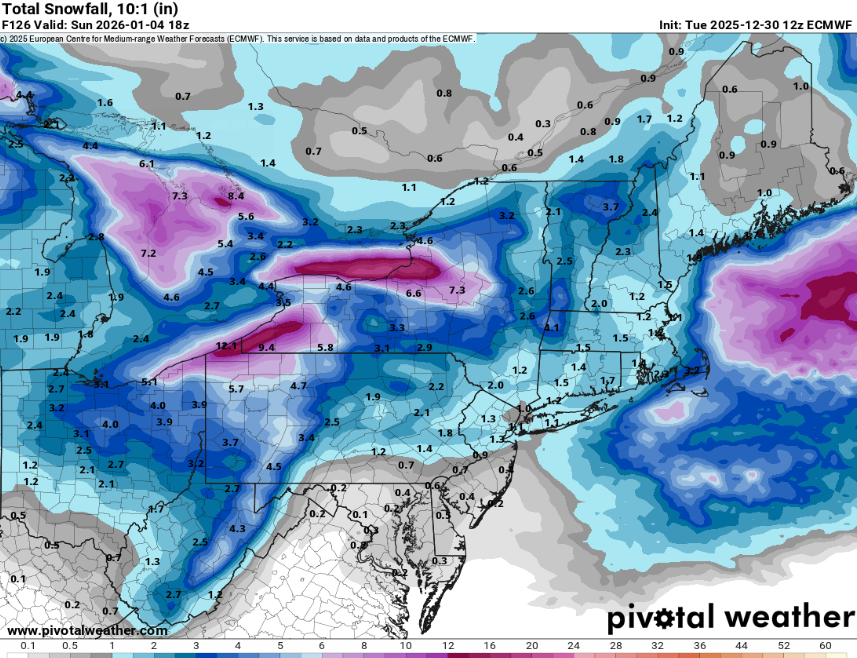
Nothing big. It did show a light snow event on 1/4. 1/6 is still there too actually but again, not a biggie. -
December was another DRY month. I received 1.76" of rain and melted snow.......... 68% of normal. 6.5" of snow gave .45" of q.p. 31 degrees at 2:30 with a 12 mph N.W. wind.
-

New Years Day 2026 - 1st snows of the new year possible
DavisStraight replied to Baroclinic Zone's topic in New England
Good storm for Novie. Hazey still hang around? -

January 2026 regional war/obs/disco thread
Chrisrotary12 replied to Baroclinic Zone's topic in New England
Am I wrong in my very limited knowledge that this generally aligns with the AMO phases? -
euro 12z
-

January 2026 regional war/obs/disco thread
mahk_webstah replied to Baroclinic Zone's topic in New England
So that’s a “no” so many ups and downs, and I don’t mean wheelies. Fortunately, up here something will probably work out. -
January 2026 regional war/obs/disco thread
dendrite replied to Baroclinic Zone's topic in New England
Pope just wants warm weather so he can get back on that crotch rocket. It’s tough to pop wheelies in this weather. -
Maybe it flips back, but we had been looking at a -NAO dominated pattern for mid-late next week that gave us a chance at a storm. Last 2-3 cycles have diminished that by both weakening the NAO a bit and bringing that big PAC trough on shore (I think @Ralph Wiggumalluded to this?). After that we evolve into a PNA/EPO ridge pattern after the 10th and that seems more or less the same as it looked yesterday and the days prior.
-
That January 10th-15th 2026 timeframe is looking more and more promising. The timing of it is eerily similar to our January 9th/10th storm from earlier this year. We definitely want no part of the Ice storm its showing. As far as clown maps go that was a doozy for central Arkansas, (53 inches ZR).
-
This is true. Miller As which used to occur 50% of the time and models did well with are about 15% now and models always were mostly helpless with Bs for DC area. Bs have 12 hour prediction of off Hatteras and next presentation over Pittsburgh and repeat cycle everywhere in between. They never have really gotten the idea that most Bs have precip shield too far NE of DC. So we continue to get a lot of sample and example but zero consistency for any predictions


