All Activity
- Past hour
-
Surprised to see a Warning already issued this morning. I like the snow forecast, conservative compared to some outputs. .WINTER STORM WARNING IN EFFECT FROM 7 PM SATURDAY TO 10 AM EST MONDAY... * WHAT...Heavy snow expected. Total snow accumulations between 7 and 10 inches. * WHERE...Portions of north central and northeast Ohio. * WHEN...From 7 PM Saturday to 10 AM EST Monday. * IMPACTS...Travel could be difficult. The hazardous conditions could impact the Monday morning commute. * ADDITIONAL DETAILS...Snow will spread into the region Saturday night and peak in intensity during the day Sunday. The snow will gradually taper off late Sunday night into Monday. Sub-zero wind chills are expected Saturday night into Sunday morning, and again Sunday night into Monday morning.
-

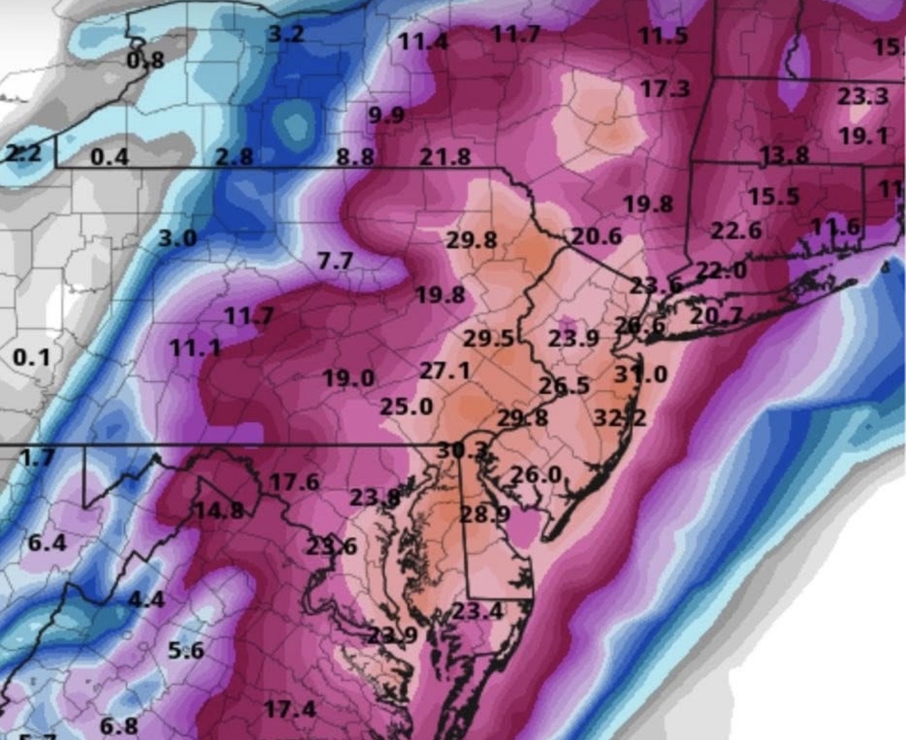
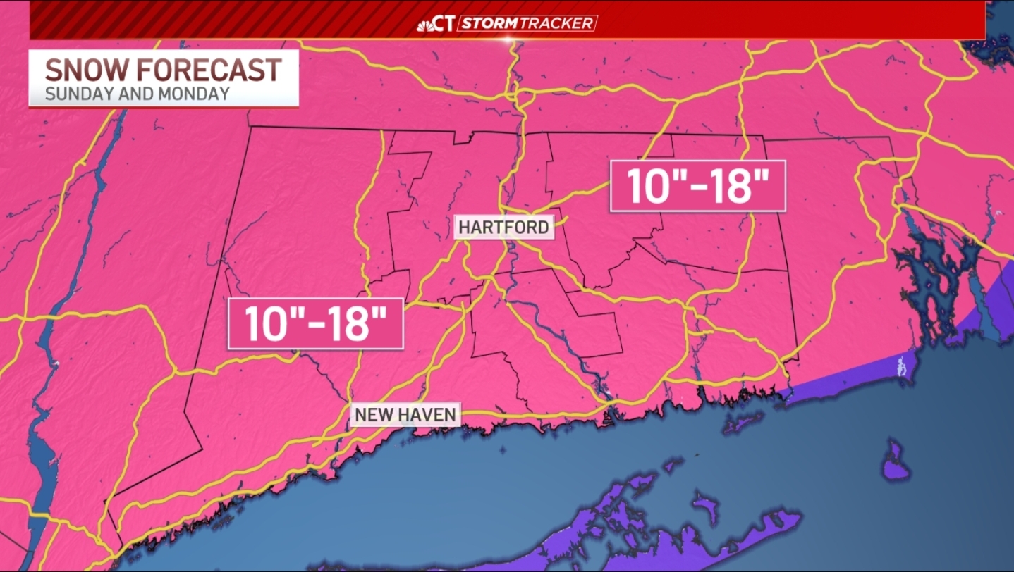
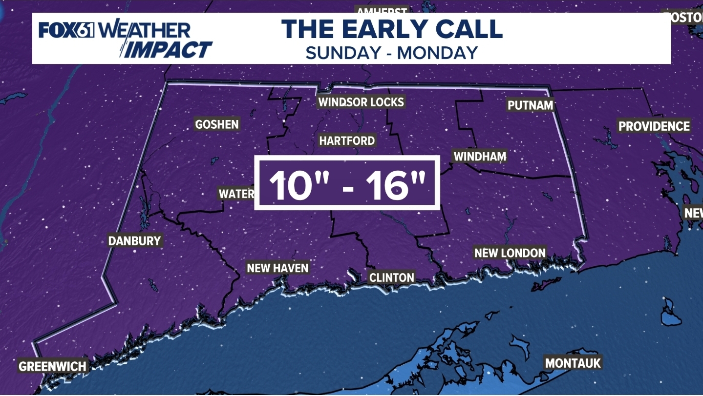
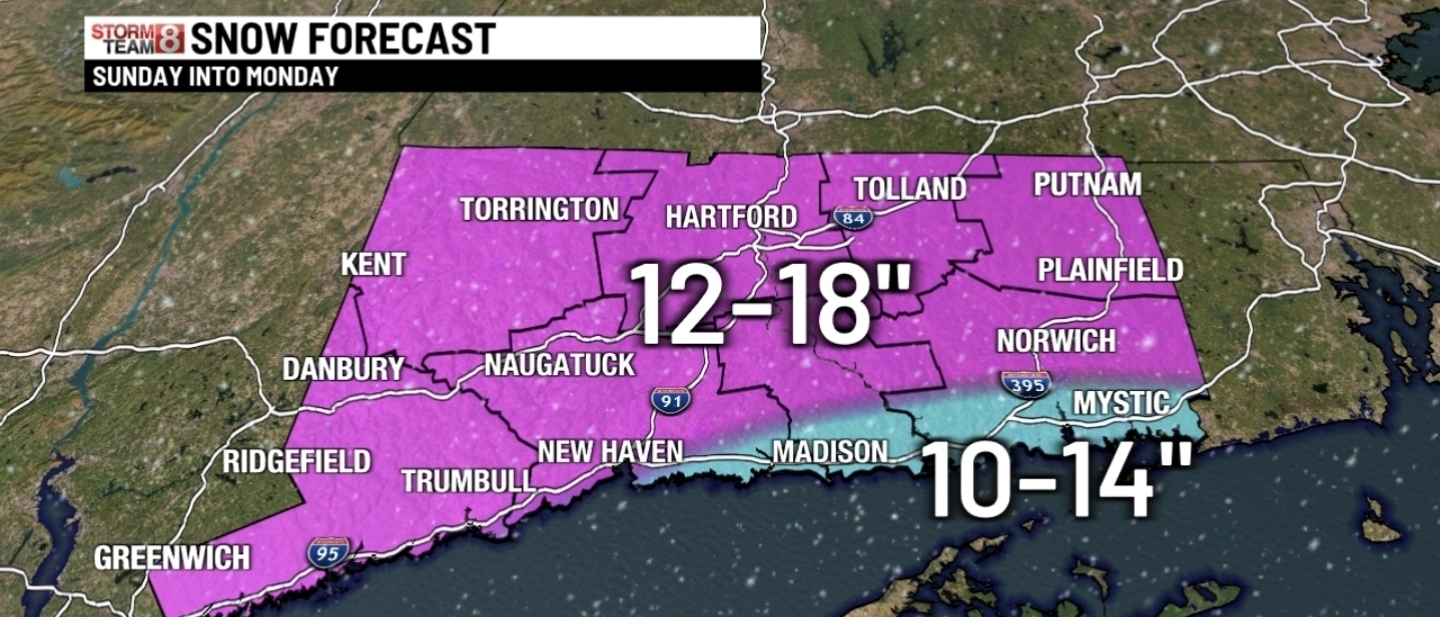
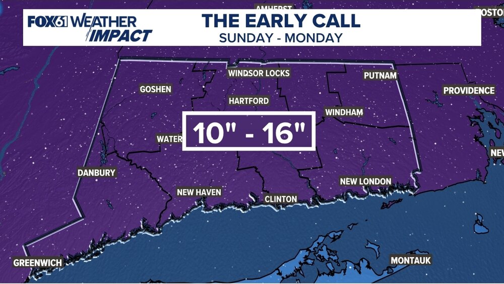
Possible Record Breaking Cold + Snow Sunday 1/25 - Tuesday 1/27
jm1220 replied to TriPol's topic in New York City Metro
If we have heavy rates we can overcome shallow layers a bit above freezing-we might get rimed flakes etc but it's when the rates are reduced and we get dry holes in the precip that the warm air can become more established. And sometimes there are sneaky warm layers that aren't captured well in the soundings. Seems like the warm layer that can flip us over would be around 750mb from what I've seen. In any case it will still snow a lot and hopefully by the time the sleet gets here we're about to shut it off anyway. That's a potent high pressure dome all that Gulf moisture is slamming into and it will take a while to warm it up. The dryslot will also be a consideration if we have a strong 700mb low tracking into Lake Erie. Dry air will pivot around the SE side of it. -

Possible Record Breaking Cold + Snow Sunday 1/25 - Tuesday 1/27
EastonSN+ replied to TriPol's topic in New York City Metro
You are right. However in the last storm it showed sleet to CT and we never turned to sleep. Its great but not always perfect. -
Mitch haven’t you heard all over Hanover people are saying we getting 2 feet. Man we must be missing something cause people keep telling me I’m wrong for 8-12” it’s going to be 20”+. Too many uneducated people out there believe whatever garbage they hear.
-
Gfs for next weekend

-

January 24-26: Miracle or Mirage JV/Banter Thread!
stormtracker replied to SnowenOutThere's topic in Mid Atlantic
You did uncharacteristically unravel for a minute tho. But glad to see you reeled it in. It’s gonna be ok. We all need to be at the acceptance stage. We can find a way to turn an epic sleet bomb fun. What other choice do we have? -

1/24-1/25 Major Winter Storm - S. IL, IN, MI and OH
michsnowfreak replied to A-L-E-K's topic in Lakes/Ohio Valley
Theres plenty of snow already on the ground ahead of the storm. Fly in sunday morning and you won't know the difference. -
https://www.weather.gov/ilm/criteria Thats what ILM states for ISW: "Freezing rain is the only or predominate type of wintry precipitation and is expected to accumulate to ¼ inch or greater during a period of 24 hours or less."
-
Yeah I’ve got a wheelbarrow with water in it and it’s still frozen. It’s in the shade but a lot of roads are in the shade .
-

Central PA Winter 25/26 Discussion and Obs
Jns2183 replied to MAG5035's topic in Upstate New York/Pennsylvania
Big Jan 96 vibes with the multiple storms and artic cold Sent from my SM-S731U using Tapatalk -

Possible Record Breaking Cold + Snow Sunday 1/25 - Tuesday 1/27
mob1 replied to TriPol's topic in New York City Metro
Sleet at least adds up and makes the snowpack last, we want to avoid rain though (NAM shows a bit at the tail end for southern parts of the city). Just need the NAM 30-40 miles south and I honestly don't care if we flip to sleet a bit earlier than modeled. -

January 24-26: Miracle or Mirage JV/Banter Thread!
LP08 replied to SnowenOutThere's topic in Mid Atlantic
Doug Kammerer just posted the raw ZR from the euro and is talking about power outages…ugh -

January 2026 regional war/obs/disco thread
tavwtby replied to Baroclinic Zone's topic in New England
looks east to me but at this timeframe, it has time to tic NW -
Too good to be true.
-
Which school? I work for KCS .
-
Snowmegaly
-
I’m honestly not sure, but my thinking is it would be a winter storm over ice storm if there’s more sleet/snow and an ice warning for above .50 with less sleet/snow. A lot of counties with a shit ton of elevation changes on top of model madness in handling the wedge will take time to sift through it all. That warm nose is as stout as the wedge and it’s going to be an awesome battle to watch unfold
-

Pittsburgh/Western PA WINTER ‘25/‘26
Rd9108 replied to Burghblizz's topic in Upstate New York/Pennsylvania
Won't let me post any pics or gifs anymore but SREFs look slightly better and a little south. -
I believe for ISW it has to be mainly ice and no snow
-

January 25-26 Winter Storm Potential
The Iceman replied to Ralph Wiggum's topic in Philadelphia Region
You’re not wrong, in this area most of the time the mixing is way stronger than modeled. However, most of the time we also don’t have a giant arctic high providing highs in the teens either. I totally get the “pessimism” so to speak though, I just think that this situation is a bit different than other events where we mix. We shall see though! -


-
Don't worry, Superman is here
-

Central PA Winter 25/26 Discussion and Obs
Blizzard of 93 replied to MAG5035's topic in Upstate New York/Pennsylvania
If you want some extra Friday weather tracking fun, check out the 6z GFS for Next weekend…wow! The GFS & some other Op/ensembles have been interested off & on for another chance next weekend. Oh & there could be a Clipper around this Thursday that takes a decent track for us a little snow pack refresher. Exciting times on here! -

Richmond Metro/Hampton Roads Area Discussion
RVASnowLover replied to RIC Airport's topic in Mid Atlantic
Same to you! We're just hoping for more snow and less ice and to not lose power. -
I’m such a freak. I’m becoming more interested in midweek freshener and next weekend than I am with the storm this weekend. Help